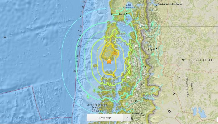
GeoLog

Natural Hazards

The best of Imaggeo in 2016: in pictures

The best of Imaggeo in 2016: in pictures

Imaggeo, our open access image repository, is packed with beautiful images showcasing the best of the Earth, space and planetary sciences. Throughout the year we use the photographs submitted to the repository to illustrate our social media and blog posts. For the past few years we’ve celebrated the end of the year by rounding-up some of the best Imaggeo images. But it’s no easy task to pick which ...[Read More]

Imaggeo on Mondays: “Vancouver! Vancouver! This is it!”

Mount St Helen's, Washington, seen from Johnston Ridge.

On May 18th 1980 Mount St Helens (an active stratovolcano of the Cascades located in the North West US), erupted explosively following a magnitude 5.1 earthquake. The quake triggered a devastating landslide which swept away the volcano’s northern flank – in what is the largest debris avalanche recorded on Earth to date. Removal of a section of the edifice depressurised the volcano’s magmatic ...[Read More]

Imaggeo on Mondays: Aoraki & a round-up of the latest New Zealand earthquake news

Imaggeo on Mondays: Aoraki & a round-up of the latest New Zealand earthquake news

On Sunday the 13th November, New Zealand’s South Island was struck by a powerful 7.8 M earthquake. Initial analysis by the United States Geological Survey (USGS) indicates that the source of the tremor was faulting on or near the boundary between the Pacific and Australia plates. A tsunami alert (no longer active) was triggered following the earthquake, with risk of tsunami waves along coastal are ...[Read More]