Display "Following Carbon Dioxide Through the Atmosphere" from YouTube Click here to display content from YouTube. Learn more in YouTube’s privacy policy. Always display content from YouTube Open "Following Carbon Dioxide Through the Atmosphere" directly Carbon dioxide plays a significant role in trapping heat in Earth’s atmosphere. The gas is released from human activiti ...[Read More]
Imaggeo on Mondays: Measuring the wind direction

Measuring the wind direction. Credit: Andrew Moss (distributed via imaggeo.egu.eu).
Remote, rugged, raw and beautiful beyond measure, the island of South Georgia rises from the wild waters of the South Atlantic, 1300 km south east of the Falkland Islands. The Allardyce Range rises imposingly, south of Cumberland Bay, dominating the central part of the island. At its highest, it towers 2935 m (Mount Paget) above the surrounding landscape. In the region of 150 glaciers carve their ...[Read More]
September GeoRoundUp: the best of the Earth sciences from around the web

Partially collapsed building as a result of the 2017 Puebla earthquake (Mexico). Credit: AntoFran. Distributed via Wikimedia Commons.
Drawing inspiration from popular stories on our social media channels, as well as unique and quirky research news, this monthly column aims to bring you the best of the Earth and planetary sciences from around the web. Major story and what you might have missed This month has been an onslaught of Earth and space science news; the majority focusing on natural hazards. Hurricanes, earthquakes and v ...[Read More]
Imaggeo on Mondays: A prehistoric forest
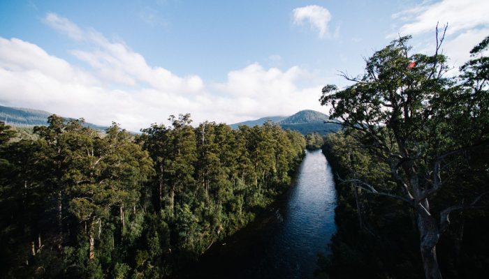
1.6 hectares of wilderness. Give me more . Credit: Vytas Huth (distributed via imaggeo.egu.eu)
This stunning vista encompasses the south-western wilderness of Tasmania as seen from the Tahune air walk 60 m above the Huon river valley. In front lies the beginning of a huge UNESCO World Heritage Site, covering almost a fourth of the area of Tasmania. The site mostly consists of a pristine, temperate rainforest of Gondwanan origin that is home to the tallest flowering trees in the world; Eucal ...[Read More]