August 15, 1950, marked India’s fourth year of Independence. The young nation’s mood was optimistic. People all over India were celebrating the country’s newfound freedom. Known as the land of the rising Sun, the jubilant people of the northeastern part of the country were about to conclude the celebrations and retire for the day. In the northeast corner, surrounded by the Himalayan mountains, the sun sets earlier than the rest of the country. That was when they felt the jolt, around 7:30 P.M., the Earth trembled beneath their feet. Earthquakes were not new for the people of the Indian province of Assam, but this was unlike anything they had experienced before. It was so powerful that the shaking lasted for 5 to 6 minutes, devastating the towns and villages, with a protracted sequence of powerful aftershocks that lasted for months.
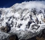
Sourced at a remote location within the hills of the northeastern Himalayas, the largest of the continental events, with a magnitude of 8.6, the Tibet-Assam temblor was felt in Northeast India, Myanmar (formerly Burma), Bangladesh (then East Pakistan), Tibet, and southern China, over an area of 3 million km². The source of this earthquake was within the cusp of the Eastern Himalayas, where the mountain chain makes a sharp southward turn, transitioning into the Indo-Myanmar Ranges, a zone of intense tectonic activity.
The epicentral location (28.6N and 96.5E) and focal depth (15 km) were derived using data from the Bureau Central International de Seismologie, Strasbourg. The magnitude of 8.6–8.7 was calculated using two seismograms recorded at Pasadena and Strasbourg. The epicentre was found to be located 40 km west of Rima (also called Zayü or Chayu), a scenic county in southeastern Tibet, where the maximum severity of the earthquake was experienced, as reported by many eyewitnesses. Botanist explorer, Kingdon-Ward, who was camping in the village of Rima at the time of the quake, describes how the ground started shaking around 8 P.M. with an “appalling noise” and how the earth began to “shudder violently”. In a letter to Nature, he describes how the earthquake mobilised millions of tons of rock and sand into all the main rivers and their tributaries, within a few days, displacing millions of cubic feet of water.
The damage from the earthquake was colossal. Approximately 4800 deaths were reported from Tibet. It caused immense property damage and destroyed railway tracks and bridges on the Indian side. On the Indian side, more than 1500 people lost their lives in the province of Assam, and the farmers lost 50,000 to 1,00,000 of their cattle population. The earthquake triggered landslides, dammed rivers, caused floods, altered river courses, and affected the landscapes. It mobilised millions of tons of rock and sand into all the main rivers and their tributaries, within a few days, displacing millions of cubic feet of water.
In an address to the nation by the Indian Prime Minister of India Jawaharlal Nehru, two weeks since the earthquake, on 7 September 1950 appraised the immensity of the event: “The Brahmaputra was blocked up for a while, and then broke through, they came down with a rush and a roar, a high wall of water sweeping down and flooding large areas and washing away villages, fields, and gardens… The remains of villages, animals—including cattle and elephants—and large quantities of timber floated down these raging waters…”. The seismotectonic importance of this earthquake was recognised in the earliest modern textbook, ‘Elementary Seismology’ by Richter (1958), which gives a detailed account of its effects, including the extensive damage and landscape changes on the Upper Assam region of India, particularly its riverine morphology.
The complex tectonics
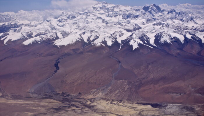
The Assam earthquake occurred before the development of the plate tectonics theory. Today, earthquake science has advanced considerably, and images of the 1950 earthquake can now be interpreted through modern seismological theories. In the Eastern Himalayas, three major tectonic plates—India, Eurasia, and Sunda – converge, forming a complex structural configuration. Furthermore, along the eastern end of the collided ranges, the main structural elements make a sharp turn, shifting the regional strike from NE-SW to NW–SE, creating the Eastern Himalayan Syntaxis (EHS), the dominant feature of this part of the plate boundary, where the 1950 earthquake originated. West of the Eastern Himalayas is the Arunachal Himalayas, extending to the Bhutan segment. To the south lies the Indo-Burmese arc region, where the subducted Indian plate slides past the Burma plate. The deformation style of the EHS transitions from strike-slip shear between India and Southeast Asia to thrusting along the Himalayan arc.
The 1950 earthquake is believed to have had a complex mechanism. Of the various proposed mechanisms, the most common is strike-slip faulting along a fault plane trending NNW-SSE (North-Northwest to South-Southeast) associated with the EHS. However, some models suggest thrust faulting on an easterly striking, gently north-dipping fault at the eastern end of the Himalayan plate boundary. Shallow thrust faulting on multiple planes, which also explains the broader zone of aftershock activity on the Himalayan side, may indicate simultaneous activation of thrust faults on both the western and eastern sides of the Himalayan bend.
Additionally, historical records, including written documents from 1228 to 1826, provide information on past earthquakes in the Assam Valley and surrounding regions. These records indicate that a major earthquake struck in CE 1697, affecting the Brahmaputra alluvial plains. Paleo-seismological investigations also suggest a medieval earthquake, dated between 1262 and 1635 CE. On 9 July 1947, a Mw 7.7 earthquake occurred near the western edge of its rupture zone. A seismic gap likely exists between the 1714 Bhutan and 1947 Arunachal earthquakes, which have remained unruptured since at least the 1697 earthquake.
What lies ahead?
The 1950 earthquake showed that the maximum credible magnitude for earthquakes in the Himalayas can reach 8.6 or higher. The northeast Himalayan bend has experienced several large earthquakes of magnitude 7 or above in the last 100 years, more than other parts of the Himalayas. The 7 January 2025, magnitude 7.1 earthquake in Tibet serves as a recent reminder of the region’s inherent seismic potential for major events. Nearly 30% of the Himalayan arc has slipped in the past 200 or 500 years, but several of its segments have not experienced earthquakes of magnitude 8.0 or above for hundreds of years.
Can we envisage a 1950s-style earthquake occurring anywhere in the Himalayas today? As we reflect on the Tibet-India earthquake 75 years later, that question remains unsettling. Just as history repeats itself, earthquakes will occur again. Most geodetic models forecast a major quake of approximately magnitude 8.6 in the Himalayas. The most probable segment to rupture is an unbroken part of the central Himalayas. Historical, archaeological, and geological evidence shows at least 500 to 600 years of seismic quietude. Long periods of inactivity increase the risk along various segments of the Himalayas.
Over the last 75 years, the built environment in the Himalayas has shifted from traditional to modern construction styles, but this change presents challenges related to earthquake resistance. Additionally, there has been an expansion of infrastructure development and urbanisation with little regard for the mountain ecosystems, earthquake vulnerability, and susceptibility to climate change. China, on the other hand, is planning the world’s largest hydropower dam on the Yarlung-Tsangpo, the source river of the Brahmaputra, very close to the eastern Himalayan bend, the source zone of the 1950 earthquake. India is also advancing its plans to dam the river on the opposite side of the border. The magnitude 7.8, 2015 Nepal earthquake, despite being smaller than the 1950 event, caused significant damage to the hydropower sector. The quake-induced landslides and rockfalls affected around 30 projects with a combined capacity of 270 MW. The recent incidents in the Uttarakhand Himalayas have demonstrated that modern dams are no match for avalanche-induced floods. The critical difference between 75 years ago and today is the significantly increased exposure to such hazards.