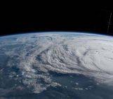
As the Early Warnings for All (EW4ALL) initiative gathers pace with its 1st Multi-Stakeholder Forum last month in Geneva, we have welcomed a recognition by experts of the importance of tailoring early warning systems to local needs. The ambition to ensure everyone on Earth is protected by a multi-hazard early warning system by 2027 is bold and demands an urgent setup of systems around the world. Delivering on this goal will require systems that are not only globally extensive but also carefully locally grounded in how they model risk, how they set early warning triggers, and how they communicate alerts for recommended actions.
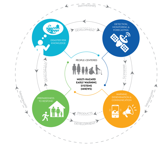
Conceptual model of a Multi-Hazard Early Warning System (MHEWS) being used in the EW4All initiative. Source: WMO
Localisation is critical to relevance
We were encouraged to see a strong emphasis on community engagement and localisation throughout discussions at the 2025 UNDRR Global Platform for Disaster Risk Reduction. At Geology for Global Development, we see these people-centred approaches as essential to delivering relevant and usable hazard risk information. But localisation must also extend to the physical and environmental data that underpins early warnings.
In many systems, the default hazard maps and models are built using national-scale or satellite-derived datasets. These are critical tools, but for hazards such as landslides and floods, small-scale changes in geology, topography, vegetation, or soil conditions can dramatically alter the hazard experienced and the local impacts. Without incorporating local physical and environmental data such as local geological mapping, vegetation mapping, and knowledge of local hazard processes, early warnings based on coarser-scale information may be inaccurate, untimely, or produce false alarms for a large proportion of those they aim to serve.
Strengthening geoscience data for the most vulnerable
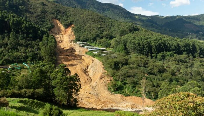
This risk of poorly designed early warnings is high, especially in some of the world’s most vulnerable areas where access to detailed, local environmental data can be limited. In these contexts, the rollout of early warning systems may need to be accompanied by efforts to strengthen geoscience data availability and the capacity of institutions that generate and maintain it. An inspiring example of this is the Colombian-German Inform@Risk initiative in Colombia, where geologists and community members in Medellin have worked together to install over 120 landslide sensors at sites mapped as having a higher risk of geophysical failure. Through this, they are developing a shared understanding of local hillslopes, their landslide risk, and how it can be locally managed through community-based early warning networks.
Our recommendations
EW4ALL and the subsequent momentum for expanding early warning systems offer an unprecedented opportunity to reduce disaster losses and save lives on a global scale. To help ensure early warning systems are truly effective for all, we encourage governments, practitioners, and funding agencies to:
- Invest in local geoscience data: Support local institutions with mapping, monitoring, and research that will improve understanding of local geology, soils, groundwater, and other physical factors that influence hazards.
- Strengthen community – scientist partnerships: Facilitate genuine collaboration between local communities and Earth scientists to co-develop monitoring networks and early warning triggers that are relevant to local decision-making.
- Build local technical capacity: Train and equip local institutions and community members to maintain, interpret, and act upon hazard monitoring data.
- Combine data sources thoughtfully: Integrate local observations with national, regional, and satellite-derived hazard information to refine risk models and warning thresholds.
- Prioritise accessible communication: Ensure that warnings and recommended actions reflect local realities and are delivered in ways that are understandable, trusted, and actionable by all at risk.
By embedding these principles, which echo the priorities we shared in our statement on the Global Platform 2025, the EW4ALL initiative can deliver early warnings that are scientifically robust, relevant to the people at risk, and genuinely life-saving. As systems expand, GfGD will continue to champion the value of local geoscience as a critical part of the conversation for early warning system success.
References
BMBF. (2025). Inform@Risk. Strengthening the Resilience of Informal Settlements against Slope Movements. https://bmbf-client.de/en/projects/informrisk
Early Warnings for All. (2025). Early Warnings for All. https://earlywarningsforall.org/site/early-warnings-all
Geology for Global Development. (2025). Geology for Global Development Home. https://www.gfgd.org/
Global Platform for Disaster Risk Reduction. (2025).The 8th Session of the Global Platform for Disaster Risk Reduction. https://globalplatform.undrr.org/
Imaggeo. (2025). Medellín. Landslide in the Quebrada Doña María by Martin Mergili, University of Graz, Graz, Austria. https://imaggeo.egu.eu/view/17396/
United Nations Office for Disaster Risk Reduction (UNDRR) and World Meteorological Organization (WMO), 2023. Executive Action Plan 2023-2027. Geneva, Switzerland