Like in a beautiful painting, layers of colour adorn the flanks of this volcano. In this week’s Imaggeo on Monday’s post, Stephanie Flude describes how these colourful layers came to be and gives an insight into why she became a geologist. What inspired you? Share your reasons for becoming a geoscientist with us in the comment section or via twitter using the hashtag #WhyGeo!
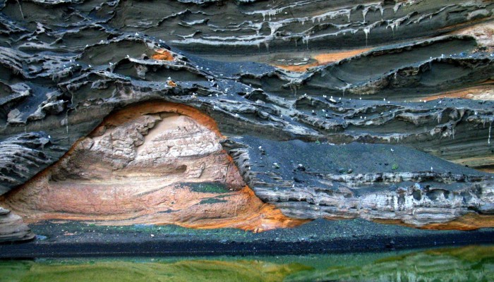
“Why do you want to study rocks??! They are just dull and grey and boring”. That is a comment I hear remarkably often when I tell people I’m a geologist. For me, the locality of this photograph is a reminder that they could not be more wrong. The rocks of the cliff are a mixture of shades of black red and orange. The sand on the beach appears black, but look closely and you find thousands of brilliant green olivine crystals. The lagoon between the beach and the cliff is also a vibrant green due to algae.
This photo shows a cliff exposing the inner stratigraphy of the El Golfo tuff cone, on Lanzarote. I first visited this location whilst on holiday in 2010 as part of a guided tour of the western part of the island. When the tour guide found out I was a geologist he offered to tell me all of the “scientific details” of the local geology and enthusiastically described how a large whirlpool was generated in the centre of cone during El Golfo’s eruption and it eroded away part of the cone(!) I smiled and nodded politely. Thankfully, since that visit, scientific work describing and interpreting the stratigraphy of the tuff cone has been published by Pedrazzi et al (2013), so it is now possible for me to more fully appreciate the geological history of this location.
Hydrovolcanism, where heat from magma can cause water to flash to steam, expanding rapidly, driving gas-rich, explosive, phreatic or phreatomagmatic eruptions, can result in many different types of volcanic eruption and associated deposits. Hydrovolcanism is not always explosive – pillow lavas form by chilling of effusive basalt lava beneath water. But adding water to a volcanic eruption can result in very violent explosions – in the 1883 eruption of Krakatoa, early eruptive activity caused sea water to flow into the magma chamber, culminating in the massive explosion that Krakatoa is so famous for. Less dramatic, but equally relevant for the modern world, hydrovolcanism is one of the reasons the 2010 eruption of Eyjafjallajökull was so disruptive to air travel; part of the eruption took place beneath a glacier, and mixing of the lava with glacial meltwater increased the violence of the eruption, sending the eruption column higher and producing finer grained material that stays in the atmosphere for longer.
El Golfo is a basaltic tuff cone that formed on the west coast of Lanzarote, next to the Timanfaya National Park, as part of a NEE-SWW oriented volcanic chain. The edifice was formed by a series of explosions driven by magma interacting with water. The dune structures visible in the lower part of the cliff in this photo are indicative of pyroclastic surge deposits that are common in hydrovolcanism. The orange / red colour shows areas of the cone that have been altered to palagonite by the still-hot basaltic glass reacting with water. Pedrazzi et al suggested that the water and steam driving the hydrovolcanism became trapped within the pyroclastic deposits and was the source of water for the palagonitization. They used the distribution of palagonite to infer that the entire cone was deposited quickly – fast enough that the upper strata were deposited before the steam had time to escape from the lower strata.
So, not quite a whirlpool in the middle of a volcano, but exciting nonetheless.
By Stephanie Flude, School of Geosciences, The University of Edinburgh
References
Pedrazzi, D., Marti, J., and Geyer, A. : Stratigraphy, sedimentology and eruptive mechanisms in the tuff cone of El Golfo (Lanzarote, Canary Islands), Bulletin of Volcanology, 75, 740, DOI: 10.1007/s00445-013-0740-3, 2013.
Imaggeo is the EGU’s online open access geosciences image repository. All geoscientists (and others) can submit their photographs and videos to this repository and, since it is open access, these images can be used for free by scientists for their presentations or publications, by educators and the general public, and some images can even be used freely for commercial purposes. Photographers also retain full rights of use, as Imaggeo images are licensed and distributed by the EGU under a Creative Commons licence. Submit your photos at http://imaggeo.egu.eu/upload/.
Pingback: Where Geology meets Art: EGU’s ImagGeo | thenoblegasbag