Dr. F. Ramón Zúñiga, from the Centro de Geociencias, Universidad Nacional Autónoma de Mexico, outlines the 19 September 2022 Mw7.7 Coalcomán, Mexico earthquake for the last Earthquake Watch of the year.
On September 19th, barely one hour after the national drill commemorating the damaging earthquakes of September 19th, in 1985 and 2017, another strong earthquake was widely felt in Mexico. It caused damage in towns neighbouring the epicentral region, near the town of Coalcomán, in the Mexican state of Michoacán. A third earthquake on September 19th, this time reaching a magnitude of Mw7.7, caused great concern among the population. According to the Civil Protection Coordination – the federal agency which oversees all activities at the federal level to mitigate the effects of natural hazards – structural and non-structural damage occurred in 5,972 houses and 116 schools mostly near the epicentral region. Also, one hospital reported severe damage, and 32 reported minor damage. Besides, 21 churches were also registered with minor damage. Damage to roads included two bridges and four rockslides, and three fatalities were accounted for (CNPC, 2022a).
Mexico is known to experience frequent large-magnitude earthquakes which in great proportion take place at the subduction boundary of the North America, Cocos, and Rivera tectonic plates. Just in the last 25 years, 15 seismic events with a magnitude 7 or larger occurred in the country according to the Mexican Seismological Service (SSN). Most of those earthquakes occurred on the Pacific coast of Jalisco, Colima, Michoacán, Guerrero, Oaxaca, and Chiapas states.
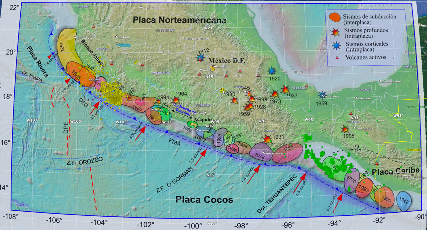
Figure 1. Detail of the rupture areas of large subduction events occurred from 1900 to 2022 (modified after Kostoglodov and Pacheco, 1999). Yellow circles are the aftershocks of the inslab interplate thrust event of 19th September 2022 (Mw 7.7). Green circles are aftershocks of the inslab event of September 17th 2017 (Mw 8.2). Yellow concentric circles mark the epicentre of the 19th September 2017 (Mw 7.1) central Mexico, earthquake. The SSN report for the event now known as an Coalcomán interplate earthquake, included a thrust focal mechanism with strike=101.9°, dip=81.7°, and rake=86.3°. Its hypocentre was located off the coast of Michoacán at a depth of 15 km (SSN, 2022). The rupture area was just west of the great Mw8.1 which occurred in 1985 (Figure 1).
At the time of writing, 140 aftershocks with M>4 have occurred, the largest taking place on 19/09/2022 (M5.3), 20/09/2022 (M5.8), 20/09/2022 (M5.4), 22/09/2022 (M6.9), and 23/09/2022 (M5.2). Figure 2 shows the time and depth history of aftershocks which occurred during the first ten days after the mainshock, together with the magnitude distribution.
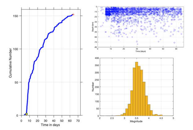
Figure 2. Time and depth history shown with the magnitude distribution of M >= 2.5 aftershocks of the September 19th 2022, Coalcomán earthquake.
The source slip model obtained by Mendoza and Martinez- Lopez, of the Center of Geosciences at UNAM (Mendoza, personal communication, September 20th, 2022) shows two large slip areas with a peak of 1.29 m. Figure 3 shows the finite fault model, and some of the recorded ground motions at UNAM stations.
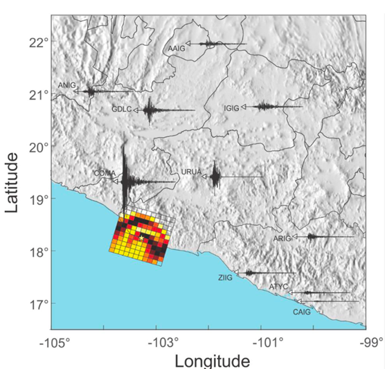
Figure 3. Finite fault model (Mendoza and Martinez-Lopez, 2022; Mendoza, personal communication, September 20th, 2022), epicentre (yellow star), and recorded ground velocities integrated from the north component of the acceleration records from UNAM’s networks. All signals are displayed with the same scale (modified after Seismic Instrumentation Group, Engineering Institute, UNAM, Report 2022).
The source model includes two regions of high slip northwest and southeast to the epicentre (depicted with a yellow star), with an apparent concentric shape from which some directivity effects might be expected, derived from the larger amplitudes at stations COMA, GDLC, and ANIG stations. A simulation (Fig. 4) using Mendoza’s source model, the finite element toolchain Hercules (Tu et al., 2006; Bielak et al., 2010), and a crustal velocity model based on a full-wave tomography (Juarez-Zuñiga and Ramirez-Guzman, 2016) was carried out by researchers at the Engineering Institute of UNAM (Seismic Instrumentation Group, Engineering Institute, UNAM, Report 2022). The simulation, valid up to 0.5 Hz, clearly shows that the energy propagates preferentially towards the north and northwest, but some high amplitude wavefronts impinged towards the northeast (station URUA in Figure 3). The probable directivity might explain the pattern distribution of the reported damages.
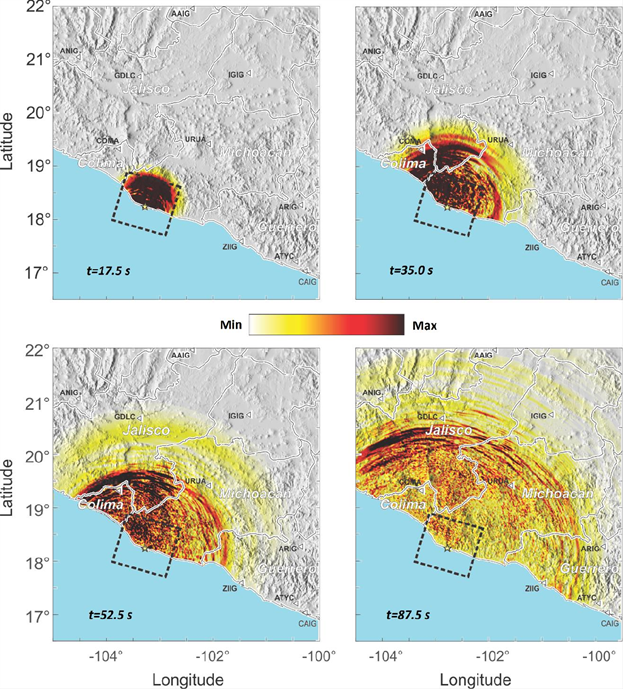
Figure 4. Ground motion simulation. The colormap displays the modulus of the horizontal velocity at times 17.5, 35, 52.5, and 87.5 s.
The record from Maruata (MMIG) station from the SSN network, located right on top of the rupture area, registered an acceleration larger than 1g in the north-south component (Fig.5).
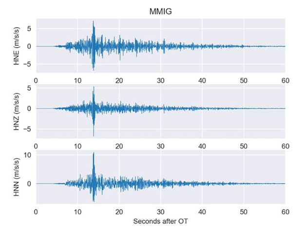
Figure 5. Acceleration records from Maruata (18.2885°, -103.3456°) station from SSN network.
Fig. 6 shows the results of the root mean square (RMS) of the horizontal (north-south and east-west components) peak ground accelerations estimated using a Bayesian kriging algorithm and the records from UNAM’s network. We can see that even though a very large acceleration was exerted near the epicentral region, the severe acceleration zone was limited and fortunately did not include major cities. Nevertheless, medium size towns were severely affected, including about 6,000 houses which were reportedly damaged (the most significant damage in adobe and unreinforced brick masonry houses, CNPC, 2022).
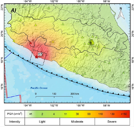
Figure 6. Mean square (RMS) of the horizontal (north-south and east-west components) peak ground accelerations map.
Considering the Tsunami threat, according to the National Mareographic Service (SMN 2022), the peak wave height in stations near the epicentre was 1.75 m in Manzanillo and 0.635 m in Acapulco. The Seismic Instrumentation Group of UNAM performed a simulation using the GeoClaw tsunami model (e.g., LeVeque et al., 2011) and a source model reported by the USGS (USGS, 2022). The tsunami amplitude profile was computed for reference points near the coastline at an isobath of 1.5 m (Figure 6). Even though the wave height modelled underestimates the reported values without considering any correction, qualitatively, the distribution in Figure 7 is consistent with the information from the Tsunami Warning Center, which issued an alert expecting abnormal sea level variations up to 0.82 m above the tide level (CNPC, 2022b).
It is worth mentioning that this event caused quite a stir in the social media, since, as mentioned, it took place on the same date (September 19th) as two previous catastrophic events in 1985 and 2017. However, despite the coincidences in date, the three earthquakes differed considerably in tectonic location and wave generation characteristics.
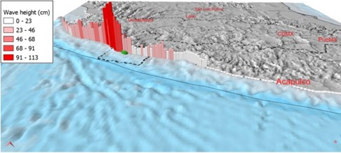
Figure 7. Maximum tsunami wave height along the Mexican shoreline computed for reference points near the coastline at an isobath of 1.5 m. The green ellipse is the epicentre of the September 19th 2022 event and the black dashed lines, the fault-plane area .
The 1985 Mw 8.1 earthquake occurred offshore the Michoacán coast (Fig. 1), with an epicentre near the city of Lázaro Cárdenas. The rupture zone had an area of approximately 12,000 km2. Both the 1985 and 2022 earthquakes were shallow (<30 km) thrust events at the interface between the two major plates that interact on the Mexican Pacific coast, the Cocos plate, and the North American plate. Noticeably, the epicentre of the 2022 earthquake was located west of the rupture zone of the 1985 earthquake. In 2022 the rupture area, corresponding to magnitude 7.7, was approximately 130km by 65km (Fig. 1), giving 8,450 km2. The 2017 Mw 7.1 earthquake was a separate case. It was not an interplate earthquake, but rather a rupture of the entire subducted plate at a depth (51 km). This was caused by the stresses of both tension when the plate bends, added to the plate’s own weight when submerged in the mantle. This earthquake had a normal type faulting mechanism with rupture of the order of 1,000 km2. Its epicentre was located at the border between the Puebla and Morelos states, near the town of Chiautla, about 125 km from Mexico City. Both the 1985 and the 2017 caused extensive damage to Mexico City, while the 2022 event was hardly felt there due to the epicentral distance and attenuation conditions.
The stresses caused by any earthquake of significant magnitude can be transferred to surrounding areas, additionally “loading” these segments with deformation energy that is added to the energy budget due to the years that have passed without releasing it. This could accelerate the occurrence of an earthquake in segments neighbouring a rupture, which may have happened between the 1985 and 2022 segments.
References
The September 19th, 2022, M7.7 Coalcoman Earthquake, An overview and preliminary analysis, Institute of Engineering, UNAM, Seismic Instrumentation Group, 2022. www.uis.unam.mx/PDF/Report_EQ190922_ver1_english.pdf, last accessed October 28th 2022.
Bielak, J., R.W. Graves, K.B. Olsen, R. Taborda, L. Ramirez-Guzman, S.M. Day, G.P. Ely, D. Roten, T.H. Jordan, P.J. Maechling, and J. Urbanic. (2010). The ShakeOut earthquake scenario: Verification of three simulation sets, Geophysical Journal International, 180(1), 375-404.
CNPC (2022a). Informe de la Coordinación Nacional de Protección Civil. Gabinete de Seguridad (in Spanish).
CNPC (2022b). Coordinación Nacional de Protección Civil, twitter account, https://twitter.com/CNPC_MX/status/1571940576123322370
Juarez-Zuñiga, A. and L. Ramirez-Guzman (2016). Adjoint-wavefield tomography of Southcentral Mexico, Geological Society of America Annual Meeting, Denver, CO.
Kostoglodov, V. and J. Pacheco, Cien Años de Sismicidad en México, http://usuarios.geofisica.unam.mx/vladimir/sismos/100a%F1os.html, last accessed 30th October 2022. 1999.
LeVeque, R. J., D. L. George, and M. J. Berger. (2011). Tsunami modelling with adaptively refined finite volume methods, Acta Numerica, 20, 211-289.
USGS report on the 19th September earthquake, 2022, https://earthquake.usgs.gov/earthquakes/eventpage/us7000i9bw/executive, last accessed 30th October 2022.
SSN | IGEF – UNAM, México, Reporte especial: Sismo del 19 de septiembre de 2022, Michoacán (M7.7), http://www.ssn.unam.mx/sismicidad/reportes-especiales/2022/SSNMX_rep_esp_20220919_Michoacan_M74.pdf, last Access 28/10/2022.
Tu, T., H. Yu, L. Ramirez-Guzman, J. Bielak, O. Ghattas, K. L. Ma, and D. R. O’hallaron. (2006, November). From mesh generation to scientific visualization: An end-to-end approach to parallel supercomputing, In SC’06: Proceedings of the 2006 ACM/IEEE conference on Supercomputing (pp. 12-12). IEEE.
This blog post was written by Guest Blogger Dr. F. Ramón Zúñiga
from the Centro de Geociencias, Universidad Nacional Autónoma de Mexico