Dee Ninis, an Earthquake Geologist and Seismologist from the Seismology Research Centre of Australia, outlines the 22 September 2021 Mw5.9 Woods Point, Australia earthquake for the first Earthquake Watch of the year.
On 22 September, 2021 at 09:15 AEST (2021-09-21 23:15 UTC) a moderate earthquake of Mw 5.9 near Woods Point, Victoria, shook southeast Australia. Felt reports were received from as far as Sydney (~590 km to the northeast), Hobart (~630 km to the south) and Adelaide (~750 km to the west) (Fig. 1). In Melbourne, ~130 km to the west of the epicentre, ground shaking was described as lasting for >30 seconds. Damage was reported from >120 sites in Melbourne city and the inner suburbs, including the collapse of unreinforced masonry, facades and chimneys. Fortunately, no lives were lost. This event was the largest onshore earthquake ever recorded in Victoria (i.e., since written records began about ~180 years ago).
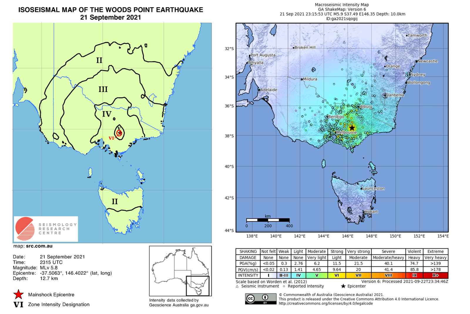
Figure 1 | (L) Mw5.9 Woods Point earthquake – isoseismal map; (R) Mw5.9 Woods Point earthquake – intensity map (Geoscience Australia: https://earthquakes.ga.gov.au/).
Woods Point is a small town (pop. ~40) in a remote region of Victoria’s mountainous high country. It is located in southeast Australia, an area which has long been recognised as one of the more seismically active regions of the continent (e.g. Lambeck et al. 1984; Gaull et al. 1990; Hillis et al. 2008) (Fig. 2). Here, in the Southeast Seismic Zone, other notable earthquakes include: the 1961 ML5.8 Boolarra (NSW) event; the 1966 ML5.7 near Mount Hotham (also in Vic.’s high country, ~100 km to the NE of Woods Point); the 1989 Mw5.4 Newcastle (NSW) earthquake, which resulted in 13 deaths, widespread destruction and losses amounting to ~AUD$4 billion; and the widely-felt 2012 ML5.4 Moe (Vic.) earthquake. Moreover, paleoseismological studies within this region have revealed geological evidence, from the last 100,000 years, for ground-rupture earthquakes of up to ~M7.0, e.g., on the Avonmore Scarp (Ninis & Clark, 2019) and the Cadel Fault (Clark, 2015).
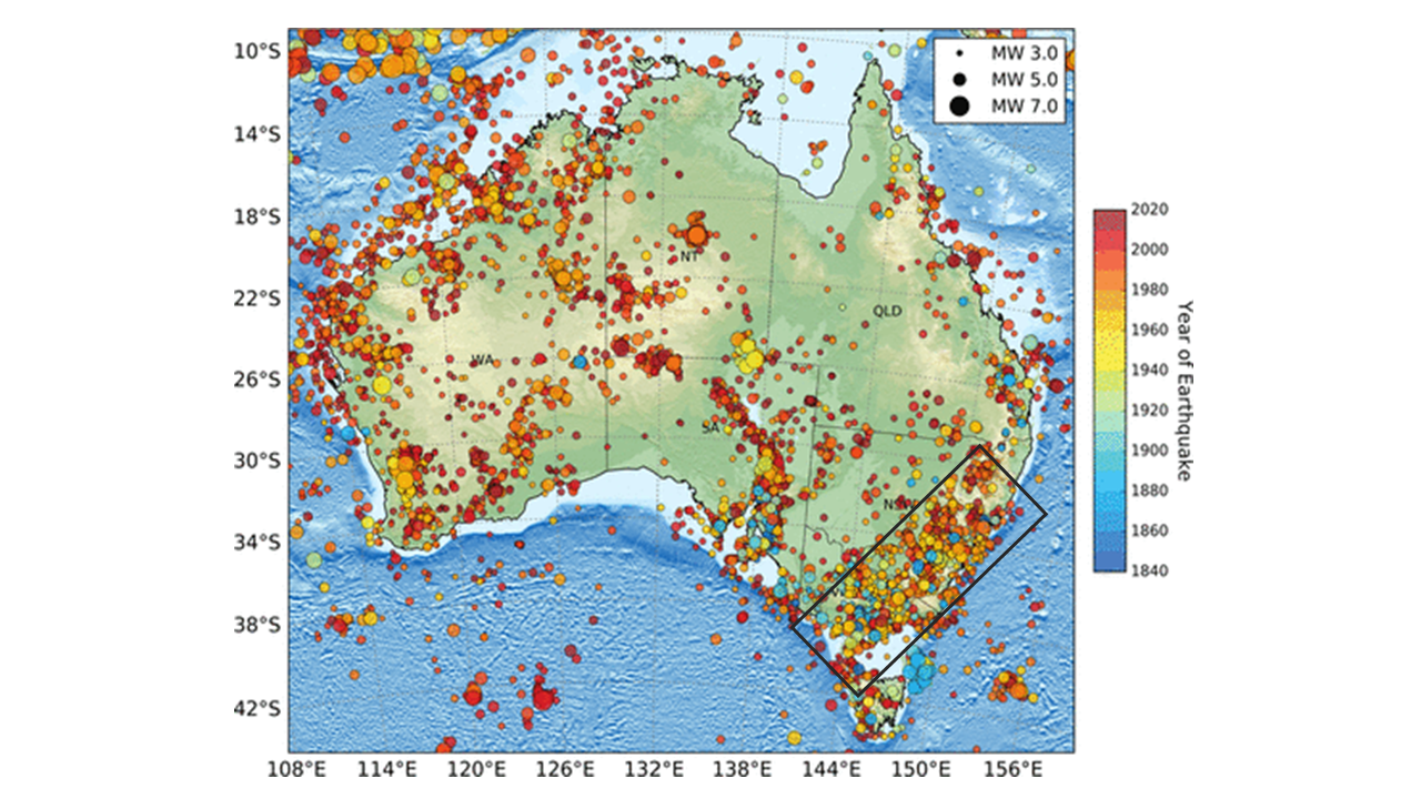
Figure 2 | Map of Australian earthquake epicenters of M ≥ 3.0 (from Allen et al. 2020) showing the southeast seismic zone.
Analysis of the waveform data by the Seismology Research Centre located the Mw5.9 Woods Point earthquake at ~12 km depth, ~15 km northeast of Woods Point. The focal mechanism solution suggests the rupture involved left-lateral strike-slip movement on a near N-S trending and steeply dipping fault. Although reverse faulting has been the predominate mechanism of rupture in recent moderate to strong Australian earthquakes, the orientation of the fault and rupture mechanism of the Mw5.9 Woods Point event accords with the maximum horizontal crustal stress in the region, which is approximately NW-SE (e.g., Rajabi et al. 2017) (Fig. 3).
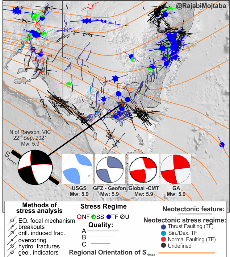
Figure 3 | Mw5.9 Woods Point earthquake – focal mechanism solutions. Also shown is maximum horizontal crustal stress SHmax (orange lines). Figure by Mojtaba Rajabi.
In the 24 hours that followed, the Mw5.9 mainshock was followed by >300 aftershocks; nearly 100 of them recorded within the first two hours, including a ML4.2 and ML3.3 at 18 mins and 39 mins, respectively, after the main shock (Fig. 4 a,b). The aftershocks generally ranged in depth from ~2 km and ~13 km, and were detected in a narrow, near-vertical zone which extended around 8 km in a near N-S orientation, in accordance with the main shock fault orientation suggested by the focal mechanism solution.
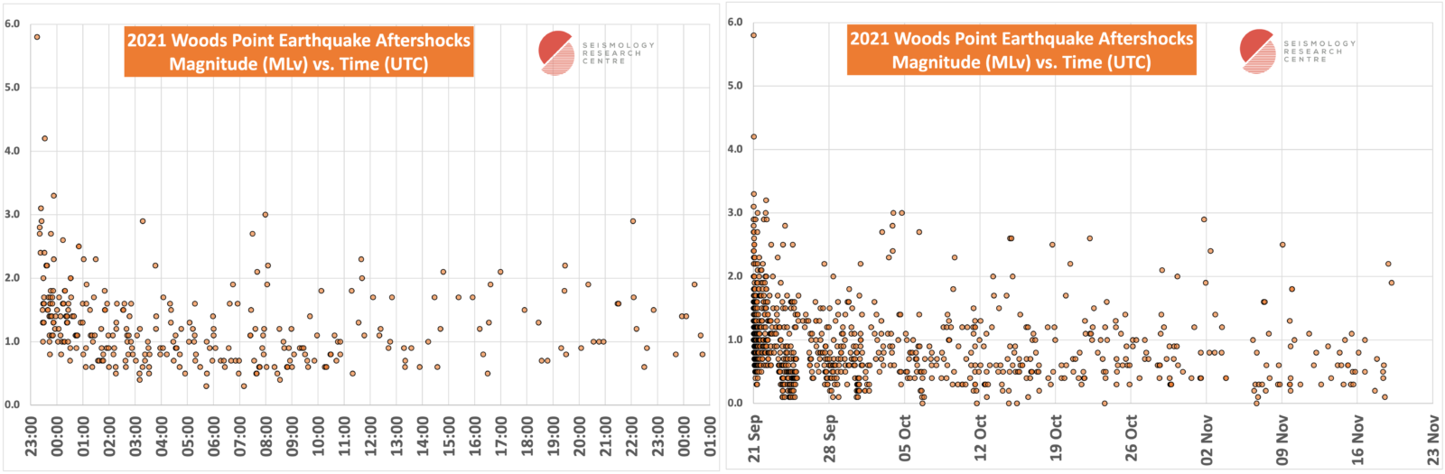
Figure 4 | Mw5.9 Woods Point earthquake and aftershocks for a) the first 24 hours after the mainshock, and b) for 2 months after the mainshock.
Reconnaissance field investigations for damage were undertaken by a team from the University of Melbourne and the Seismology Research Centre. There was minimal structural damage of buildings close to the epicentre, including to some unstable man-made structures and precarious geological features. Elsewhere, rare, isolated rock falls and fallen trees were noted (Quigley & La Greca, 2021). There was no evidence of liquefaction. The field investigations and, later, InSAR data, identified no surface rupture associated with this earthquake.
The minor local damage at Woods Point, especially when compared to the structural damage reported across Melbourne ~130 km to the west of the epicentral region, is attributed to the strike-slip nature of the rupture and source geometry, whereby energy was radiated away from nearby towns such as Woods Point. We infer that the local Siluro-Devonian bedrock geology also supported minimal damage; in comparison, the softer Tertiary fluvial sediments beneath Melbourne likely amplified ground-shaking as a result of the earthquake.
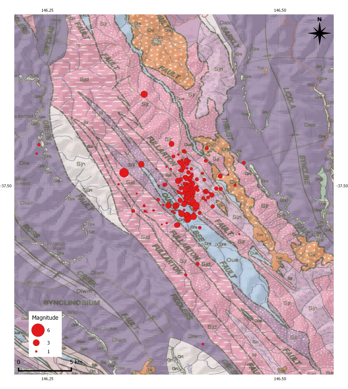
Figure 5 | Local geology of the Woods Point region, showing bedrock faults and location of the Woods Point Mw5.9 earthquake and aftershock sequence for the first ~48 hours.
There were no previously-identified active or neotectonic faults in the region surrounding the Mw5.9 Woods Point earthquake. While the aftershock epicentre distribution may roughly align with the trend of older faults identified in geological mapping of the region (VandenBerg 1997 – Fig. 5), seismic reflection data suggests that some of these features are too shallow, while others are east-dipping and listric at depth (Cayley et al. 2011 – Fig. 6). The focal mechanism solution and hypocentre distribution suggest that the fault source responsible for the Mw5.9 Woods Point event is near-vertical between ~2-13 km depth. As such, we infer that the source fault is a deeper structure – one that hasn’t been identified at the surface – and that the mainshock may even have ruptured through some of the previously-identified faults at depth.
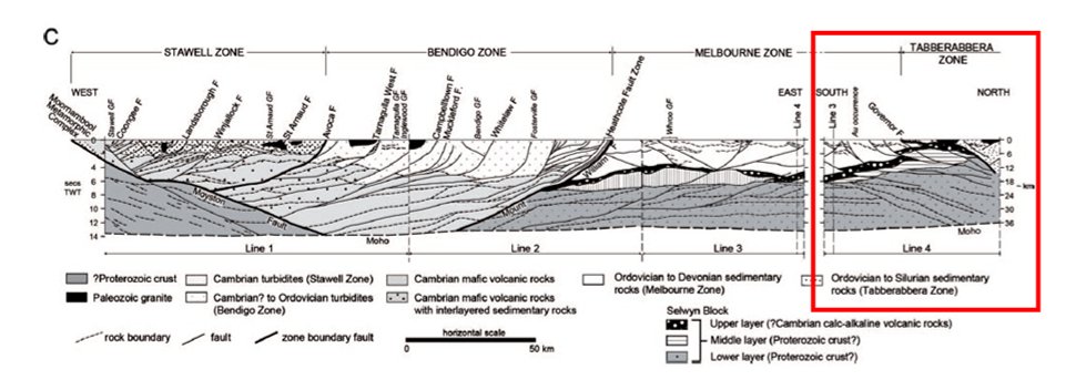
Figure 6 | Seismic interpretation of the subsurface geology across the central north of Victoria, including faults. Red square shows the predominately east dipping faults in the Woods Point region. Figure from Cayley et al. (2011).
And more than 4 months after the Mw5.9 mainshock, the aftershock sequence continues. A few weeks ago, there was a M3.2 earthquake – a near-equal second largest aftershock, and the largest since the day of main event in September last year (Fig. 7).
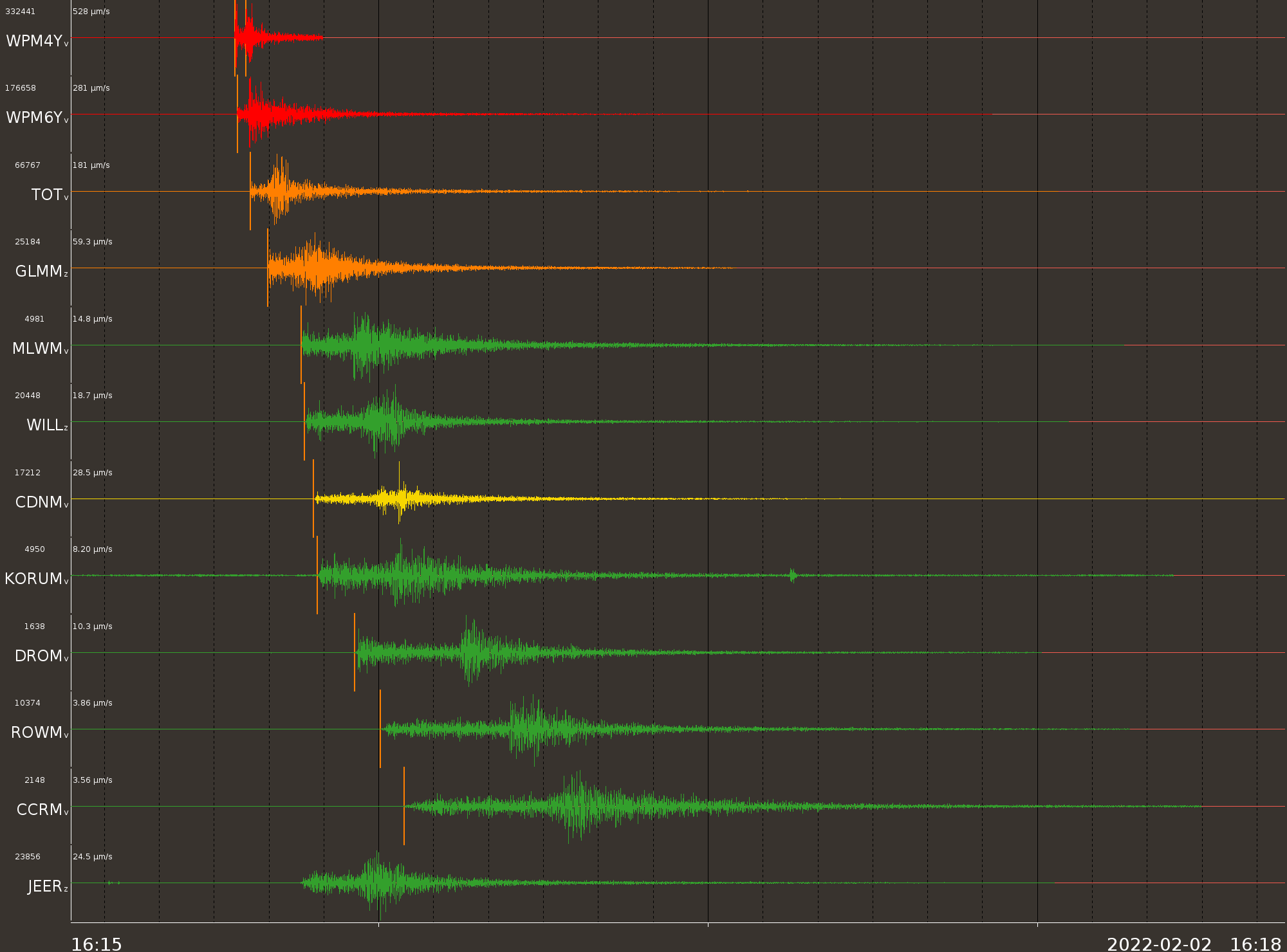
Figure 7 | Seismic waveform for a recent aftershock of the Mw5.9 Woods Point earthquake – this event is a M3.2 on 2022-02-02 16:18 UTC.
References
Cayley, R.A., Korsch, R.J., Moore, D.H., Costelloe, R.D., Nakamura, A., Willman, C.E., Rawling, T.J., Morand, V.J., Skladzien, P.B. and O’Shea, P.J., 2011. Crustal architecture of central Victoria: results from the 2006 deep crustal reflection seismic survey. Australian Journal of Earth Sciences, 58(2), pp.113-156.
Clark, D., A. McPherson, M. Cupper, C. D. N. Collins, and G. Nelson (2015). The Cadell Fault, southeastern Australia: a record of temporally clustered morphogenic seismicity in a low-strain intraplate region, Geological Society London Special Publication: Seismicity, Fault Rupture and Earthquake Hazards in Slowly Deforming Regions 432 163-185.
Gaull, B.A., Michael‐Leiba, M.O. and Rynn, J.M.W., 1990. Probabilistic earthquake risk maps of Australia. Australian Journal of Earth Sciences, 37(2), pp.169-187.
Hillis, R.R., Sandiford, M., Reynolds, S.D. and Quigley, M.C., 2008. Present-day stresses, seismicity and Neogene-to-Recent tectonics of Australia’s ‘passive’margins: intraplate deformation controlled by plate boundary forces. Geological Society, London, Special Publications, 306(1), pp.71-90.
Lambeck, K., McQueen, H.S., Stephenson, R.A. and Denham, D., 1984. The state of stress within the Australian continent. In Annales Geophysicae (1983) (Vol. 2, No. 6, pp. 723-741).
Ninis, D. and Clark, D., 2019. Fault investigation practice in Australia and New Zealand: Why Australian dam owners and operators should care about collecting active fault data. In: Proceedings of the ANCOLD Conference, 2019.
Rajabi, M., Tingay, M., Heidbach, O., Hillis, R. and Reynolds, S., 2017. The present-day stress field of Australia. Earth-Science Reviews, 168.
Quigley, M. and J. La Greca, 2021. Rapid reconnaissance survey of environmental and infrastructure damage from the September 2021 Mw 5.9 Woods Point earthquake, Victoria, Australia. http://learningfromearthquakes.org/2021-09-22-australia/index.php?option=com_content&view=article&id=71
VandenBerg, A.H.M., 1997. Australia 1:250 000 Geological Map Series, Warburton Sheet SJ 55-6 Edition 2. Geological Survey of Victoria.
This blog post was written by Guest Blogger Dee Ninis (Twitter: @DeeNinis)
from the Seismology Research Centre of Australia (Twitter: @AusQuake)