The second blog of the SENSOR series shares the experiences of three scientists from the Dublin Institute for Advanced Studies (DIAS, Ireland), Dr. Patrick Smith, Dr. Nima Nooshiri, and Dr. Ka Lok Li, who are working on the exciting ‘EUROVOLC’ project to bring the European volcanological community closer together. In March, they flew to Iceland to deploy two seismic arrays near the volcano at Fagradalsfjall and to assist with monitoring efforts for the spectacular eruption occurring in those days. If you are interested, read below what they told us about this unique adventure!
“The global Covid-19 pandemic has been a new and difficult experience for all of us, including geoscientists in need to carry out fieldwork, with the logistical challenges of travel and physical distancing adding extra complexity to the task of deploying and maintaining instruments in the field. Nature however has no such concerns, and the ongoing volcano-tectonic unrest on the Reykjanes peninsula in Iceland, that began in 2020 and led to the eruption at Fagradalsfjall in March this year, proved an unmissable opportunity to study the precursors to the reactivation of several volcanic systems in a relatively accessible location, as well gaining insights into its origins.
Through many past collaborations, DIAS has close links with the Icelandic Meteorological Office (IMO) who monitor earthquake and volcanic activity in Iceland, so this was ideal for us to jump in and offer assistance. DIAS is also a partner in the broad and ambitious EUROVOLC project that aims to promote an integrated and harmonised European volcanological community. One of the project’s main themes focuses on understanding sub-surface processes, with an aim to develop and improve schemes for detecting pre-eruptive unrest. Volcanic tremor is a sustained seismic signal that is often associated with such volcanic unrest and has been linked to the movement of magmatic fluids in the subsurface. During the 2014–2015 eruption of Bárðarbunga in Iceland it was shown to originate from microseismicity in the uppermost crust during dyke formation (Eibl et al., 2017).
Seismic arrays, or small clusters of seismic stations are particularly suited for analyzing volcanic tremor, as by stacking or beamforming the signals from all the stations the array can point towards the source, and can therefore be used to estimate lateral and vertical migration of tremor sources. The size, shape, and number of stations in an array determine the frequency of the seismic waves that can be resolved and analyzed. Small arrays with an aperture of a few km or hundreds of metres are most suited for deployment on volcanoes, where in general the stations are quite close to the source.
For our deployment in Iceland, we designed two eight-station arrays that we tuned to try and capture any pre-eruptive tremor signals, which typically have frequencies around 1Hz, as well as potentially higher frequency body waves arriving with faster apparent velocities. At the time of writing, the two arrays have already been deployed and were installed during a two-week long field trip in March. The arrays are approximately circular in design with an aperture of about 1.2 km, and were deployed around 5 and 6km to the SE and SW of the eruption site at Fagradalsfjall (Figure 1). Once we are able to retrieve our data, these arrays will allow us to test a new software package designed for real-time analysis of seismic array data (Smith & Bean, 2020), and provide a chance to study the details of any pre-eruptive unrest signals.
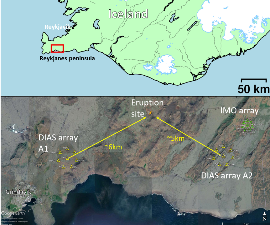
Figure 1 | Map of the southern Reykjanes peninsula in Iceland, showing the location of the two DIAS seismic arrays deployed within a few km of the eruption site at Fagradalsfjall. Also shown is a third array deployed and operated by IMO.
As well as the two arrays, a much denser profile of stations is planned to be deployed right across the suspected dyke intrusion at Fagradalsfjall in order to try and image the magmatic intrusion through analysis of reflections from its edges using nearby seismicity as sources. This part of the deployment has been somewhat delayed due to shipping, logistical and vaccination(!) challenges, but this should be a unique and exciting dataset that will allow us to test new methods of imaging the subsurface during volcanic unrest and help provide insights into the nature and origins of the intrusion that led to the eruption.
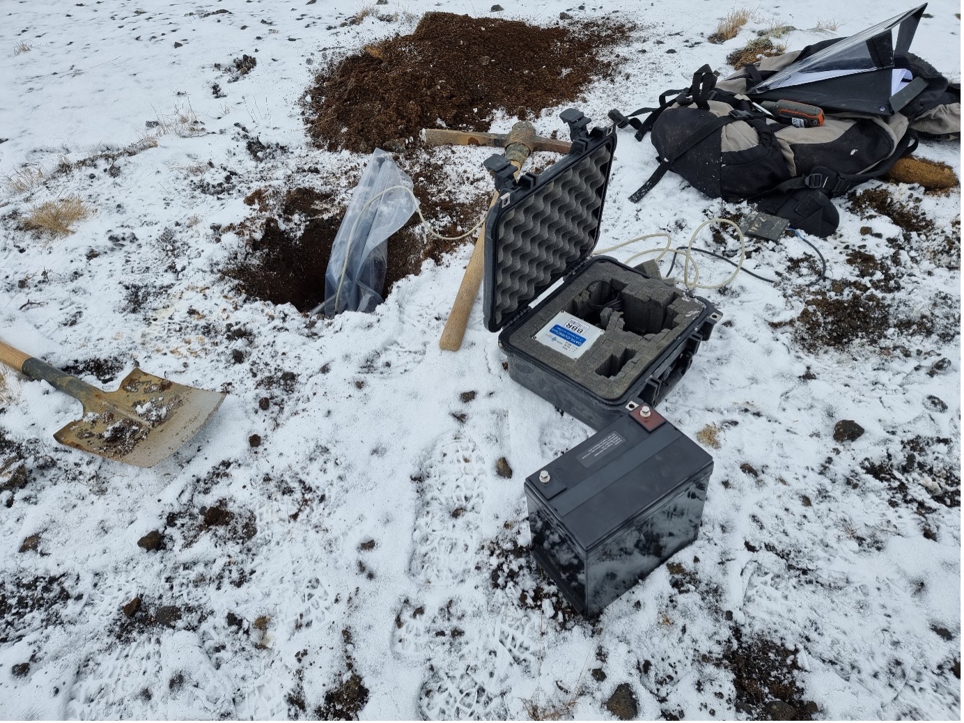
Figure 2 | Deploying a seismic station as part of the arrays.

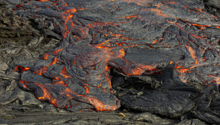
Figure 3 | Visiting the eruption site.
Because of the pandemic, the first third of the trip to Iceland was spent in quarantine in our rental accommodation, which was, of course, disappointing. But on the bright side, it gave us the chance to carefully calibrate our arrays so that they are optimized to catch the seismic signals that we expect to see. It also gave us time to plan our activities in the field because we knew that we had no time to waste once we were out of quarantine.
Our first target was to deploy array A1 (the location is shown in Figures 1 and 2). Don’t be fooled by its location. It may appear to be close to the road and lying on a flat lowland, but we had to hike over a valley to get there. With all the carrying of heavy batteries and instruments, in the end, it took us almost three days to make the array fully operational. For the second array A2, we were much luckier as we got assistance from the IMO, and they helped us distribute all the instruments using their all-terrain vehicles so that all we needed to do was hike to the sites with our backpacks. That significantly shortened the deployment time to only one day.
If it was not for the help from the IMO, we would not have finished our tasks early and would have missed our chance to visit the eruption site (a snapshot in Figure 3). To be honest, for some of us this was our first time seeing a volcanic eruption in person. The lava fountains, the lava flows… in front of our eyes, it was a picture that was so familiar (because we see it so many times in the media) but so new (because it was our first time seeing it live). How magnificent Mother Nature is! Imagine how much force it takes to eject the lava out and to push it forward. Yet, it is done so easily, with no effort. We will never forget the feeling of having a face that is oven-like hot while our back was freezing cold. This was perhaps a unique experience that we could only have got from an Icelandic volcanic eruption.”
I am sure we are all jealous of this fantastic experience, and let’s wish for Paddy, Nima and Ka Lok to get some beautiful seismic data! Stay tuned for the next blog…
References
Eibl, E.P.S., Bean, C.J., Vogfjörd, K.S., Ying, Y., Lokmer, I., Möllhoff, M., et al. (2017). Tremor-rich shallow dyke formation followed by silent magma flow at Bárðarbunga in Iceland. Nature Geoscience 10(4), 299-304. doi: 10.1038/ngeo2906.
Smith, P. J. and Bean, C. J., (2020), RETREAT: A REal-Time TREmor Analysis Tool for Seismic Arrays, With Applications for Volcano Monitoring. Front. Earth Sci. 8:586955. doi: 10.3389/feart.2020.586955
This blog post was written by Patrick Smith, Nima Nooshiri, and Ka Lok Li and ECS representative Chiara Civiero
with revisions from ECS representative Maria Tsekhmistrenko.