For any field-based seismologist, there is nothing more satisfying than standing in a remote location, laptop in hand finalising the installation of a new broadband seismic station. In 2013 this feeling was amplified as we deployed the first, and still the only broadband seismic array in the Democratic People’s Republic of Korea (DPRK, the formal name for North Korea). That it took almost two years of discussion and diplomacy to get there made it all the more rewarding.
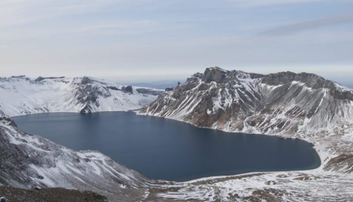
Mount Paektu is a large caldera volcano that straddles the DPRK-China border. In the scientific community, it is best known for the 946 CE VEI 7 eruption [1] that deposited ash across Japan and the Kuril Islands. Its ash has even been identified in ice cores from Greenland. From 2002-2005, an increase in seismicity, gas emissions and ground deformation put the region on alert and refocused attention on the volcano. In 2011, Clive Oppenheimer (a volcanologist from Cambridge University) and I were invited to visit the volcano to meet DPRK volcanologists and explore the scope for collaboration. As an early-career scientist finishing a fixed-term position, it seemed the perfect opportunity, and a few weeks after receiving the invitation we landed in Pyongyang with no idea of what to expect.
We were the first western scientists to visit the volcano observatories, learning first-hand of the DPRK geoscientists’ efforts to monitor the volcano and of the geophysical and geological research they had done to understand its history and structure. We also learned about the cultural importance of the volcano for all Koreans. It quickly became clear that there were many areas of common interest. For example, despite its dramatic history, little is known about the origin of this intraplate volcano and its geological and recent eruptive history.
This is where it began to get hard. From the very beginning, we received strong support from the American Association for the Advancement of Science (AAAS), the Royal Society of London and a Beijing based NGO called the Environmental Education Media Project. All were interested in the project for its scientific merits, but also as an example of science diplomacy – a loose term to cover the area where science and diplomacy overlap [2]. In our case, volcanology was recognised as a great way to build relationships and develop trust and understanding in a non-political way. However, despite our clear intention to focus on the geoscience and stay away from geopolitics, this was not always possible.
At around this time, tensions on the Korean Peninsula were growing. Weapons tests and military exercises had increased, leading to strained relationships and mounting political pressure. Our original plans involved a joint seismic and magnetotelluric campaign to image partial melt in the crust beneath the volcano. However, through long discussion with the UK and US Government, it became clear that some of the magnetotelluric equipment was considered dual-use (apparently, it can be used for submarine detection). This required a revision of our plans and a focus on seismology alone. Instead of a single year-long deployment, we extended to two years to try and use passive seismology to image the crust. Finally, after 18 months of deliberations, export licenses were approved for the seismic equipment by the UK and US Government and we could ship our equipment to DPRK.
The fieldwork itself was the easy part. Our DPRK colleagues had already covered local logistics for the installations, including the construction of concrete vaults to house the seismometers. We simply needed to turn up and plug in our kit while admiring the view and joining in the many impromptu karaoke sessions as we drove between sites. Personal highlights include hiking up the volcano through thigh-deep snow carrying seismic equipment to fix a faulty station, enjoying a birthday party in the foothills of the volcano and hosting the film director Werner Herzog at the time we decommissioned the array.
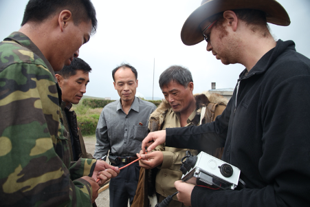
Deploying seismometers with the earthquake Administration, DPRK (credit: Clive Oppenheimer)
After the deployment, we have hosted DPRK scientists in the UK, and have met regularly in Pyongyang, allowing us to develop new seismic models of the magmatic system beneath the volcano, first beneath the DPRK side of the volcano [3] and more recently, in collaboration with scientists from both DPRK and China, to image beneath both sides of the volcano [4]. All data from our array are now publicly available on IRIS for the international community to use [5].
This relatively modest project has shown that geoscientific collaboration in DPRK is possible despite severe political strain. This success has a wider significance since many volcanoes are located in border regions, and geohazards do not recognise international frontiers, adding political complexities [6]. The situation on the Korean Peninsula is highly dynamic, and recent additional sanctions now require us to obtain export licenses from the UN Security Council as well as international governments to conduct our work. We have recently established the Mount Paektu Research Centre at Birkbeck to facilitate the management of these important bureaucratic issues but it aspires also to act as a focal point for other researchers interested in scientific collaboration with DPRK. New seismic projects are already funded but waiting for the COVID-19 situation to improve to enable the deployments. These will include an exciting development: the first cross-border seismic array on the volcano. This promises to deepen further our understanding of the origin of the volcano. I am looking forward to that exhilaration of being back in the field, deploying instruments to record seismic waves from local and distant earthquakes. Each trace will tighten the constraints on a new, much more detailed model of the crust and mantle beneath this extraordinary volcano.
References
[1] Oppenheimer C, Wacker L, Xu J, Galván JD, Stoffel M, Orchard A, Guillet S, Corona C, Sigl M, Di Cosmo N, Hajdas I, Pan B, Breuker R, Schneider L, Esper J, Fei J, Hammond JOS, Büntgen U
[2] Hammond, J.O., 2016. Understanding volcanoes in isolated locations: engaging diplomacy for science. Science & Diplomacy, 5(1).
[3] Kyong-Song, R., Hammond, J.O. S., Chol-Nam, K., Hyok, K., Yong-Gun, Y., Gil-Jong, P., Chong-Song, R., Oppenheimer, C., Liu, K.W., Iacovino, K. and Kum-Ran, R., 2016. Evidence for partial melt in the crust beneath Mt. Paektu (Changbaishan), Democratic People’s Republic of Korea and China. Science Advances, 2(4), p.e1501513.
[4] Hammond, J.O. S., Wu, J.P., Ri, K.S., Wei, W., Yu, J.N. and Oppenheimer, C., 2020. Distribution of partial melt beneath Changbaishan/Paektu volcano, China/Democratic People’s Republic of Korea. Geochemistry, Geophysics, Geosystems, 21(1), p.e2019GC008461.
[5] The Mount Paektu Geoscientific Group (MPGG). (2013). Mt. Paektu Seismic Network. International Federation of Digital Seismograph Networks. https://doi.org/10.7914/SN/1U_2013
[6] Donovan, A. and Oppenheimer, C., 2019. Volcanoes on borders: a scientific and (geo) political challenge. Bulletin of Volcanology, 81(5), p.31.
This blog post was written by Dr James Hammond a seismologist at Birkbeck, University of London
with revisions from ECS representative Walid Mansour and Maria Tsekhmistrenko