Extreme rainfall and strong winds can each cause major disruption. When they occur together—or within only a few days of each other—their combined impacts can be even more severe. Heavy rainfall may saturate soils and increase flood risk, while strong winds can damage infrastructure, disrupt transport and bring down trees or power lines.
Forecasting these events is essential for early-warning systems, yet extremes are particularly difficult to predict because they are rare and often influenced by local processes. In our recently published study in Geoscientific Model Development, we explored whether past atmospheric conditions could help us forecasting isolated and compound wind and precipitation extremes across Europe.
Searching the past similar atmospheric conditions
Our approach is based on atmospheric analogues. The idea is simple: when the current large-scale atmospheric circulation resembles a situation observed in the past, the weather that followed that historical situation may provide information about what could happen next.
We combine these analogs with a stochastic weather generator (SWG). After identifying a set of similar atmospheric states, the generator randomly moves through their historical evolutions to produce possible future weather sequences.
We developed two versions of this approach. For extreme precipitation, the HC-SWG combines the weather generator with atmospheric analogues selected from ECMWF ensemble reforecast/hindcast (HC). For extreme wind speed, the MA-SWG uses multivariate analogues (MA) derived from two atmospheric variables: geopotential height at 500 hPa and sea-level pressure. Together, these variables describe both the mid-tropospheric and near-surface circulation associated with wind extremes.
Each approach generates an ensemble of 100 forecast trajectories. We tested them at nine European locations representing different climatic conditions. The forecasts were evaluated at lead times of up to ten days.
How skillful were the forecasts?
Both stochastic weather generators showed useful skill in forecasting extreme events.
The HC-SWG reproduced the timing of many observed heavy-precipitation events and performed particularly well for moderate extremes. The MA-SWG also captured the occurrence of many wind extremes, although its performance varied more between locations, especially for the rarest events.
When compared with ECMWF forecasts, both stochastic approaches provided added value across the studied locations. Their probabilistic forecasts generally represented the observed distributions and forecast uncertainty more realistically. In several cases, the ECMWF ensemble covered a relatively narrow range of possible outcomes, whereas the stochastic forecasts generated a broader distribution that was closer to observations.
However, both approaches tended to overestimate the magnitude of some of the most intense events. This distinction is important: the models could often correctly identify that an extreme would occur, even when its forecasted intensity was too high.
Forecasting compound extremes
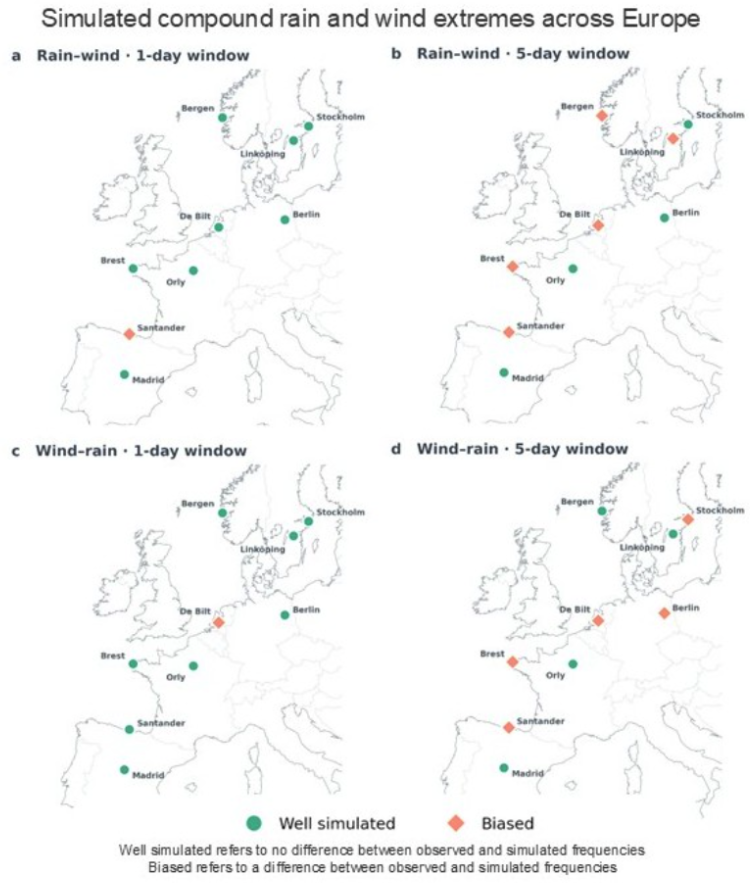
We then combined the precipitation and wind forecasts to investigate compound events. We considered simultaneous events, in which extreme rainfall and wind occurred at the same time, as well as sequential events, in which one extreme followed the other within one to five days.
At Atlantic-influenced locations such as Brest and Bergen, for example, strong winds were more frequently followed by heavy precipitation. This is consistent with the passage of Atlantic storm systems, which can bring strong winds before their associated rainfall. Other locations displayed a different ordering or similar frequencies of the two possible sequences.
The models overestimated sequential events at some stations, particularly when longer time windows were considered. Nevertheless, they reproduced many of the main spatial features of compound wind and precipitation extremes.
Looking ahead
The location-dependent performance highlights one limitation of the method: large-scale atmospheric analogues cannot fully represent local influences such as topography and other small-scale processes. Moreover, the relatively short ECMWF reforecast archive restricts the availability of suitable analogues to the rarest circulation states.
Future research could explore calibration techniques to reduce intensity biases, improve analogue selection and extend the approach to other hazards and geographical regions.
Despite these limitations, our findings demonstrate that the atmosphere’s past can provide valuable information about its near future. Combining atmospheric analogues, numerical reforecasts and stochastic simulations offers a flexible and computationally efficient approach for forecasting both isolated and compound weather extremes. These results do not suggest that stochastic weather generators should replace numerical weather prediction. Instead, they show how analogue-based methods can complement dynamical forecasts, for example through statistical post-processing and the generation of large ensembles at a relatively low computational cost. They may therefore provide valuable support for early-warning systems, particularly for compound hazards that remain challenging for existing forecasting tools.
The full study is available in Geoscientific Model Development: Krouma and Messori (2026), “Ensemble forecasts of isolated and compound wind and precipitation extremes in Europe using HC-SWG (v3.1) and MA-SWG (v1.1) Stochastic Weather Generators”.
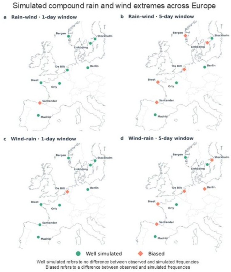
Fig. Simulating Compound Rain and Wind Events Across Europe for 1 and 5 day forecast window. Rain–wind denotes events in which extreme rainfall precedes extreme wind, whereas wind–rain denotes events in which extreme wind precedes extreme rainfall. Values represent the difference between the observed and simulated numbers of events.