Knowledge gaps in our understanding of the Hydrological Cycle
The water cycle continuously provides us with fresh water. A critical process in the water cycle is evapotranspiration (ET), meaning that water evaporates from the surface and transpires from plants into the atmosphere. ET plays a crucial role in climate stability and the regulation of global water resources, but it is one of the most uncertain components of the water cycle. Due to its sensitivity to climatic conditions and human activities, estimating and understanding the drivers of ET is so challenging that it is considered one of the most important 23 unsolved problems in hydrology (Blöschl et al., 2019).
Another challenge in hydrology is the closure of the water budget (Lehmann et al., 2022), meaning that precipitation should be equal to the sum of runoff, ET, and changes in water storage. Closing the water budget is crucial for advancing our understanding of global water fluxes, but it remains difficult due to uncertainties in estimating ET and runoff. To make things even more complicated, there are several estimates for precipitation, ET, and model based storage change available, and there is no combined product yet that closes the water budget. In addition, this leads to more than a few thousand possible combinations of ET estimates with a vast spread.

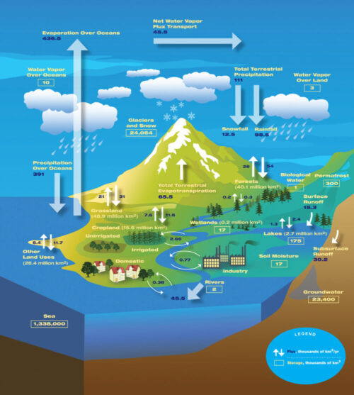
Figure 1. The hydrological cycle – estimates of observed main water reservoirs and the flow of moisture through the system (in 103 km3). (Credit: NASA/JPL) Source: https://www.flickr.com/photos/atmospheric-infrared-sounder/8264025043
The variation in possible estimates of ET from the water budget equation introduces a new challenge: Determining the most accurate estimate or combining these estimates. Additionally, there is often significant variability in the existing ET estimates, leading to uncertainties in the water budget, particularly in regions with extensive human modifications, like irrigated agriculture. The various existing approaches to estimate ET include remote sensing based, reanalysis based, hybrid based, machine learning based and water-balance based models (Tang et al., 2024). Remote sensing and reanalysis based ET models often overlook anthropogenic influences, resulting in gaps in our understanding of the hydrological cycle. For example, irrigated fields can dramatically change local ET, which traditional models may underestimate. Finally, errors in water budget closure primarily arise from uncertainties in ET, making it a complex and integrated challenge.
How GRACE Revolutionized Water Budget Estimates
One of the major developments in hydrology has been the use of the GRACE (Gravity Recovery and Climate Experiment) satellite mission to monitor global water storage changes. With this satellite mission, it was possible for the first time to estimate global water storage changes based on observations. GRACE data have been used for mapping human-induced water storage changes, such as those caused by intensive irrigation or groundwater pumping, that significantly affects the water budget. This capability is especially important in regions like the Amazon and Ganges Basins, where natural and human-driven changes are dominant.
In our recent study (Goswami et al., 2024, available at https://doi.org/10.1088/1748-9326/ad63bd) we took advantage of using GRACE data and addressed the challenges of reconciling the water budget components. We combined 96 distinct water budget-based ET estimates together with GRACE observations of water storage changes in a Kalman filter framework, resulting in a best estimate of ET with minimized uncertainties. The resulting product is called KF-ET and has an uncertainty margin of less than 2 mm per month. Our method leverages GRACE data to track changes in water storage due to irrigation as well as climatic factors, providing a clearer and more accurate picture of how water is moving through complex systems. We focused on two areas: the Ganges Basin, known for its irrigation and complex cropping patterns, and the Amazon Basin, known for its intricate interactions between energy, water dynamics, and vegetation response.

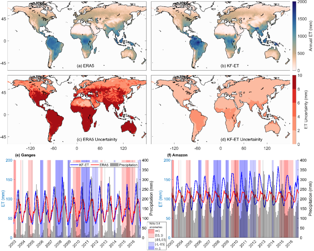
Figure 2. Mean Annual ET for 2003-2016 from (a) ERA5 and (b) KF-ET datasets. (c) and (d) represent uncertainties in ERA5 and KF-ET respectively. Time series of monthly ET plots for (e) Ganges and (f) Amazon river basins (Reconstructed from Goswami et al. 2024)
Case Study 1: Ganges Basin
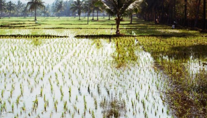
In the Ganges River basin, agriculture – particularly rice farming – is the dominant activity. Saplings are typically transplanted in late May or early June with flood irrigation beginning in June already due to pumping of groundwater (Joseph & Ghosh, 2023). This leads to rapid surface characteristics changing from dry and bare soil in May to flooded fields with minimal vegetation in June and finally to flooded fields with significant vegetation in July and August. In existing products, ET peaks in July and August when monsoon precipitation along with vegetation are high. However, our KF-ET product shows a different picture, with ET peaking in June, as it better accounts for flooding and surface changes during the early stages of crop growth. Traditional ET products often ignore the effects of flooding and irrigation, but KF-ET corrects this by incorporating GRACE data to track storage changes. In years with more water available (such as 2011), KF-ET captures higher ET values, aligning with observed in-situ data and Variable Infiltration Capacity model (Hydrological modeling).
Case Study 2: Amazon Basin
The Amazon Basin, a key region for global climate regulation, presents unique challenges for ET estimation. In this region, deep-rooted trees can access water during the dry season, maintaining higher ET levels than estimated by remote sensing and reanalysis based ET. KF-ET accounts for these variations by using GRACE data to track water sources below the Earth’s surface and adjusting ET estimates accordingly. Our study found that KF-ET better captures inter-annual variability and seasonality over the Amazon. While traditional ET products peak during the wettest part (June to September) of the year, KF-ET shows increased ET during the dry season (December to March) when trees access deeper soil water. ET variations are primarily governed by the availability of two key factors: (a) moisture (water) and (b) solar radiation (energy), which drives the transformation of water into vapor. As a result, ET can either be water-limited or energy-limited. This analysis highlights the energy-limited nature of ET in the Amazon Basin, where abundant precipitation and deep-root access ensure year-round water availability for vegetation.
Conclusion: An improved ET product based on GRACE, Kalman Filter and Water Budget
The need for accurate ET estimates has never been more pressing, particularly in the face of climate change and increasing water demands. By using GRACE satellite data and improving the ET estimates employing water budget and Kalman filter, we provide a crucial tool for scientists and policymakers. Our KF-ET could serve as a benchmark ET product for regions like the Ganges and Amazon Basins, where both natural variability and human interventions significantly affect the hydrological cycle. With better tools to estimate ET, we can now tackle some of the most critical challenges in hydrology and help build a more sustainable future for global water management.
Edited by Bene Ascheneller, Rebekka Steffen, and Marius Schlaak
References

Blöschl, G., Bierkens, M. F. P., Chambel, A., Cudennec, C., Destouni, G., Fiori, A., Kirchner, J. W., McDonnell, J. J., Savenije, H. H. G., Sivapalan, M., Stumpp, C., Toth, E., Volpi, E., Carr, G., Lupton, C., Salinas, J., Széles, B., Viglione, A., Aksoy, H., … Zhang, Y. (2019). Twenty-three unsolved problems in hydrology (UPH)–a community perspective. Hydrological Sciences Journal, 64(10), 1141–1158. https://doi.org/10.1080/02626667.2019.1620507

Goswami, S., Rajendra Ternikar, C., Kandala, R., Pillai, N. S., Kumar Yadav, V., Abhishek, Joseph, J., Ghosh, S., & Dutt Vishwakarma, B. (2024). Water budget-based evapotranspiration product captures natural and human-caused variability. Environmental Research Letters, 19(9), 094034. https://doi.org/10.1088/1748-9326/ad63bd

Joseph, J., & Ghosh, S. (2023). Representing Indian Agricultural Practices and Paddy Cultivation in the Variable Infiltration Capacity Model. Water Resources Research, 59(1). https://doi.org/10.1029/2022wr033612

Lehmann, F., Vishwakarma, B. D., & Bamber, J. (2022). How well are we able to close the water budget at the global scale? Hydrology and Earth System Sciences, 26(1), 35–54. https://doi.org/10.5194/hess-26-35-2022

Tang, R., Peng, Z., Liu, M., Li, Z. L., Jiang, Y., Hu, Y., Huang, L., Wang, Y., Wang, J., Jia, L., Zheng, C., Zhang, Y., Zhang, K., Yao, Y., Chen, X., Xiong, Y., Zeng, Z., & Fisher, J. B. (2024). Spatial-temporal patterns of land surface evapotranspiration from global products. Remote Sensing of Environment, 304(May 2023), 114066. https://doi.org/10.1016/j.rse.2024.114066


