ERE
Energy, Resources and the Environment

subsidence

Words on Wednesday: River flood risk in Jakarta under scenarios of future change

Words on Wednesday aims at promoting interesting/fun/exciting publications on topics related to Energy, Resources and the Environment. If you would like to be featured on WoW, please send us a link of the paper, or your own post, at ERE.Matters@gmail.com.

***

Budiyono, Y., Aerts, J. C. J. H., Tollenaar, D., and Ward, P.: River flood risk in Jakarta under scenarios of future change, Nat. Hazards Earth Syst. Sci. Discuss., 3, 4435-4478, doi:10.5194/nhessd-3-4435-2015, 2015.

Abstract:

Given the increasing impacts of flooding in Jakarta, methods for assessing current and future flood risk are required. In this paper, we use the Damagescanner-Jakarta risk model to project changes in future river flood risk under scenarios of climate change, land subsidence, and land use change. We estimate current flood risk at USD 143 million p.a. Combining all future scenarios, we simulate a median increase in risk of +263 % by 2030. The single driver with the largest contribution to that increase is land subsidence (+173 %). We simulated the impacts of climate change by combining two scenario of sea level rise with simulations of changes in 1 day extreme precipitation totals from 5 Global Climate Models (GCMs) forced by 4 Representative Concentration Pathways (RCPs). The results are highly uncertain; the median change in risk due to climate change alone by 2030 is a decrease by −4 %, but we simulate an increase in risk under 21 of the 40 GCM-RCP-sea level rise combinations. Hence, we developed probabilistic risk scenarios to account for this uncertainty. Finally, we discuss the relevance of the results for flood risk management in Jakarta.

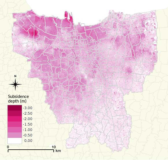
Spatial distribution of projected total land subsidence over the period 2012–2025.

Spatial distribution of projected total land subsidence over the period 2012–2025.


Row, Row, Row Your Boat: Predicting Flood Impact with Aqueduct Global Flood Analyzer

Row, Row, Row Your Boat: Predicting Flood Impact with Aqueduct Global Flood Analyzer

The Aqueduct Global Flood Analyzer of the World Research Insitute is a web-based interactive platform which measures river flood impacts by urban damage, affected GDP, and affected population at the country, state, and river basin scale across the globe. It aims to raise the awareness about flood risks and climate change impacts by providing open access to global flood risk data free of charge.

The Analyzer enables users to estimate current flood risk for a specific geographic unit, taking into account existing local flood protection levels. It also allows users to project future flood risk with three climate and socio-economic change scenarios. These estimates can help decision makers quantify and monetize flood damage in cost-benefit analyses when evaluating and financing risk mitigation and climate adaptation projects.

In short, the results of the Analyzer are meant to provide a first impression of the distribution of risk among countries, provinces, and basins. This provides an indication of risk magnitude, and an impression of the magnitude of future change in risk that can be expected. The results should be used to focus attention on particular vulnerable areas and open dialogues on the risks and how they can be managed. The results can certainly not be used for the dimensioning of specific flood protection measures. This would require more detailed and locally calibrated models that include additional information on local conditions, including more accurate river profiles, structures, existing flood protection, reservoir conditions and management during floods, and more accurate information on exposure and vulnerability. It would also require thorough engagement with local experts and stakeholders.

The Aqueduct Global Flood Analyzer was developed in collaboration with Deltares, Utrecht University, the Institute for Environmental Studies of the Free University of Amsterdam and the Netherlands Environmental Assessment Agency.

The mysterious subsidence of the seafloor due to oil production – How to predict it with a simple model?

by Daniel Keszthelyi
Physics of Geological Processes group at the Department of Physics, University of Oslo

Over 40 years of oil production from the Ekofisk field caused the overlying seafloor to sink over 9 meters during the years and while there have been numerous researches on the topic; the clear understanding of what happens with the reservoir rocks during production is still missing. We created a simple model of compaction with physics-based assumption to estimate the magnitude of the subsidence.

The Ekofisk field situated some 320 km off the coast of Norway is one of the largest petroleum fields of the country. Oil is produced from carbonate rocks (chalk) lying almost 3 km below the seabed to an oil platform standing in 76 meter deep water. The depletion of oil from the carbonate rocks caused a dramatic decrease in the pore pressure in these rocks and in turn a large increase in the effective stress acting to them. This increased effective stress then led to their compaction which was much more significant than expected by previous models.

The compaction has positive effect on the oil production as it pushes out oil from the rock; however it also puts at risk the surface facilities (oil platform and pipelines) and decreases the permeability of the rock making the flow of fluids inside them more difficult.

Our new model of compaction is based on very simple assumptions and describes rock as a collection of pores where these pores are material weaknesses. Imagine a sheet of paper with a small cut made in the middle of the paper. Then if you try to tear or shear the paper slowly you can see that this cut starts to grow until the sheet of paper is torn into two pieces. Similar things happen to the rock if effective stresses are increased: the pores – like the small cut in the middle of the sheet of paper – will become nuclei of new fractures and eventually a fracture network will be created. According to linear elastic fracture mechanics the larger the pore the less stress is needed to involve it into fracturing and vice-versa the larger the stress the smaller pores can be fractured: so with increasing effective stresses considerably more fractures can be created.
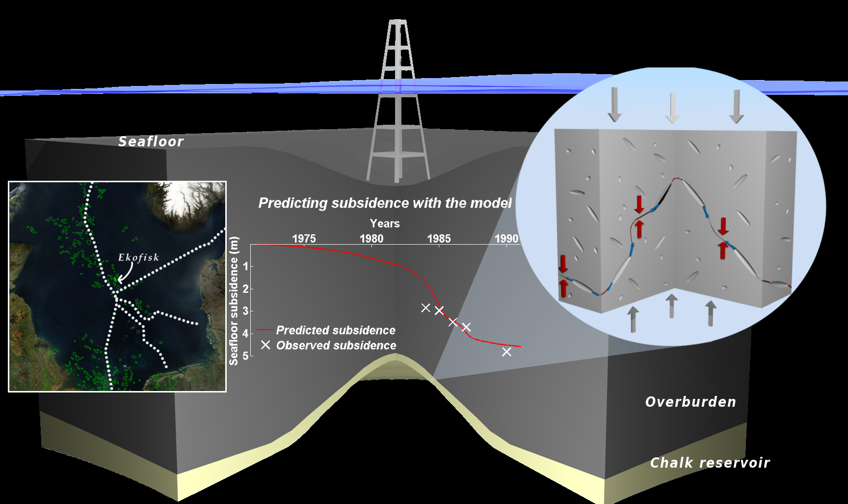
The Ekofisk field: location, mechanism of compaction and predicted subsidence (by Daniel Keszthelyi)

The Ekofisk field: location, mechanism of compaction and predicted subsidence (by Daniel Keszthelyi)

Fluids originally inside the pores can flow into these new fractures and if the fluid is water or partly water it can dissolve the material of rock: in carbonates calcite. The exact mechanism is called pressure solution which vaguely speaking means that the solubility of calcite depends on the pressure and therefore it can dissolve at grain-grain contacts along the new fracture and precipitate anywhere else. According to our model this dissolution will lead to the compaction of the carbonate rock.

The speed of dissolution can be calculated from pressure solution theories and the number of fractures can be calculated by statistical means and therefore the speed of deformation (the strain rate) can be predicted knowing some parameters without using any fitting parameters. All we have to know is porosity, pore size distribution, effective stress, water saturation, temperature and how the solubility of calcite depends on pressure and temperature: all of these can be measured independently in laboratory experiments.

If we apply this model to the Ekofisk field using an estimated pressure history of the reservoir we get quite good agreement with the measured subsidence values. This means that with a very simple model with no fitting we are able to predict the subsidence of the Ekofisk field. Furthermore, with simple modifications might also help to better understand other subsidence cases related to oil, gas or water production.

This post is based on the EGU talk Compaction creep by pore failure and pressure solution applied to a carbonate reservoir by Daniel Keszthelyi, Bjørn Jamtveit and Dag Kristian Dysthe. Daniel Keszthelyi is a PhD candidate at the Physics of Geological Processes group at the Department of Physics, University of Oslo. For further information please contact daniel.keszthelyi @fys.uio.no.