Words on Wednesday aims at promoting interesting/fun/exciting publications on topics related to Energy, Resources and the Environment. If you would like to be featured on WoW, please send us a link of the paper, or your own post, at ERE.Matters@gmail.com.
***
Wiesmeier, M., Lungu, M., Hübner, R., and Cerbari, V., 2015. Remediation of degraded arable steppe soils in Moldova using vetch as green manure, Solid Earth, 6, 609-620, doi:10.5194/se-6-609-2015, 2015.
Abstract:
In the Republic of Moldova, non-sustainable arable farming led to severe degradation and erosion of fertile steppe soils (Chernozems). As a result, the Chernozems lost about 40% of their initial amounts of soil organic carbon (SOC). The aim of this study was to remediate degraded arable soils and promote carbon sequestration by implementation of cover cropping and green manuring in Moldova. Thereby, the suitability of the legume hairy vetch (Vicia sativa) as cover crop under the dry continental climate of Moldova was examined. At two experimental sites, the effect of cover cropping on chemical and physical soil properties as well as on yields of subsequent main crops was determined. The results showed a significant increase of SOC after incorporation of hairy vetch mainly due to increases of aggregate-occluded and mineral-associated OC. This was related to a high above- and belowground biomass production of hairy vetch associated with a high input of carbon and nitrogen into arable soils. A calculation of SOC stocks based on equivalent soil masses revealed a sequestration of around 3 t C ha−1yr−1 as a result of hairy vetch cover cropping. The buildup of SOC was associated with an improvement of the soil structure as indicated by a distinct decrease of bulk density and a relative increase of macroaggregates at the expense of microaggregates and clods. As a result, yields of subsequent main crops increased by around 20%. Our results indicated that hairy vetch is a promising cover crop to remediate degraded steppe soils, control soil erosion and sequester substantial amounts of atmospheric C in arable soils of Moldova.
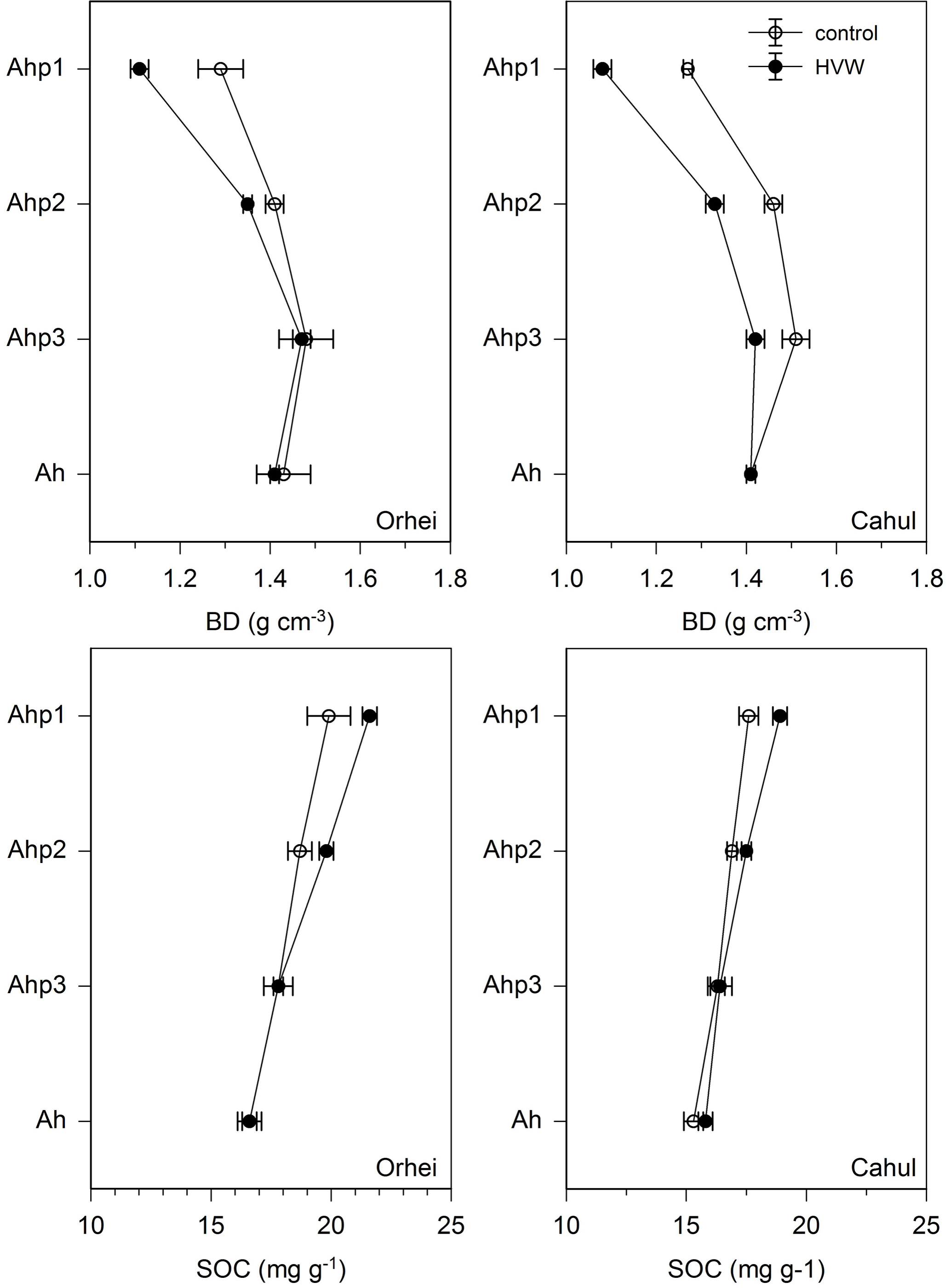
Bulk densities (BD) and soil organic carbon (SOC) contents
of topsoil horizons of control and experimental sites in Orhei
and Cahul after incorporation of HVW and harvest of the main crop. Error bars represent standard deviation (n = 10).