ERE
Energy, Resources and the Environment

ERE matters

The Pore Space Scramble

by Alexandra Gormallya and Michelle Benthamb
aLancaster Environment Centre, Lancaster University, Lancaster, LA1 4YQ, UK; bBritish Geological Survey, Keyworth, Nottingham, NG12 5GG, UK

The underground is being used more to help us meet some of the challenges facing humans from tackling climate change, waste disposal to ensuring energy security. The notion of ‘pore space’ and its commodification, has gained much momentum over the last few years in policy circles, industry and the natural (geo)sciences alike. However ‘pore space’ and the use of the underground is now also being discussed within the social sciences too. Human geographers in particular are starting to critically discuss some of the ways in which society uses, perceives and interacts with the subsurface in the past, present, and different ways of how this might happen in the future. Through this examination, social scientists are beginning to interact with geoscientists. This has led to a collaborative engagement between human geographers in the Lancaster Environment Centre, with geoscientists at the British Geological Survey. Through this collaboration the notion of The Pore Space Scramble was born.

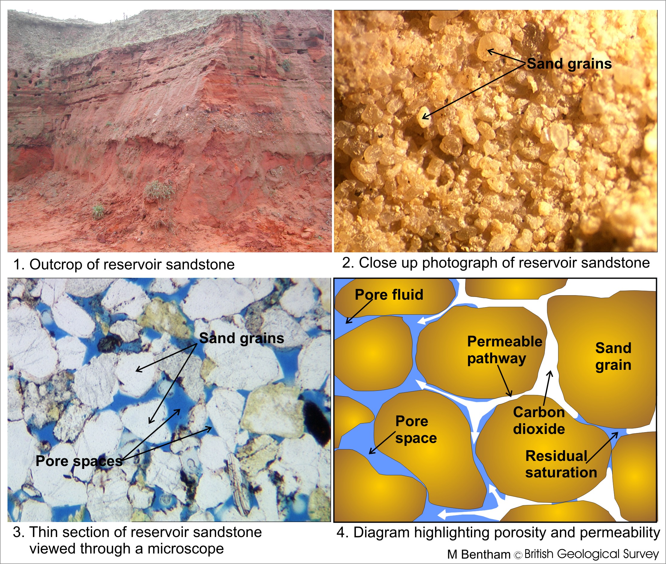
So, what is pore space and why might there be such a scramble for its use? Pore spaces are voids between rock grains that contain liquid or gas. The connection of pores then form pathways in which water, oil or gas can move. The interest in pore space therefore, is of interest due to its potential to store materials such as heat, gas or water. Uses of the pore space form a complex system so to simplify this we frame our discussion around the use of pore space for the long-term storage of CO2 as a result of Carbon Capture and Storage (CCS). CCS is a suggested route to decarbonising the power and industrial sectors.

Going down in scale: from the outcrop to the pore space (by the British Geological Survey)

Going down in scale: from the outcrop to the pore space (by the British Geological Survey)

There is strong political will behind CCS both at the European level and in the UK itself [1], the UK setting out a 3 phase road map to commercialise CCS going forward. Given this political drive, it is not only necessary to understand the technical capabilities and practical ability to take this technology forward it also raises many questions around society and governance of such a system into the future. For example, who has precedence over this space and how does it compete with other energy infrastructure on both the surface and subsurface (eg. oil & gas industry, windfarms)? What are the legal and regulatory standpoints of this space i.e. who owns the pore space and therefore legally be able to utilise its use? What are the long-term stewardship plans of this space (eg. 10, 100, 1000 years), how does this effect liability and how might the precedence of such industries change over time? Ultimately, how do we ethically and justly govern such a space both presently and when projected into the future?

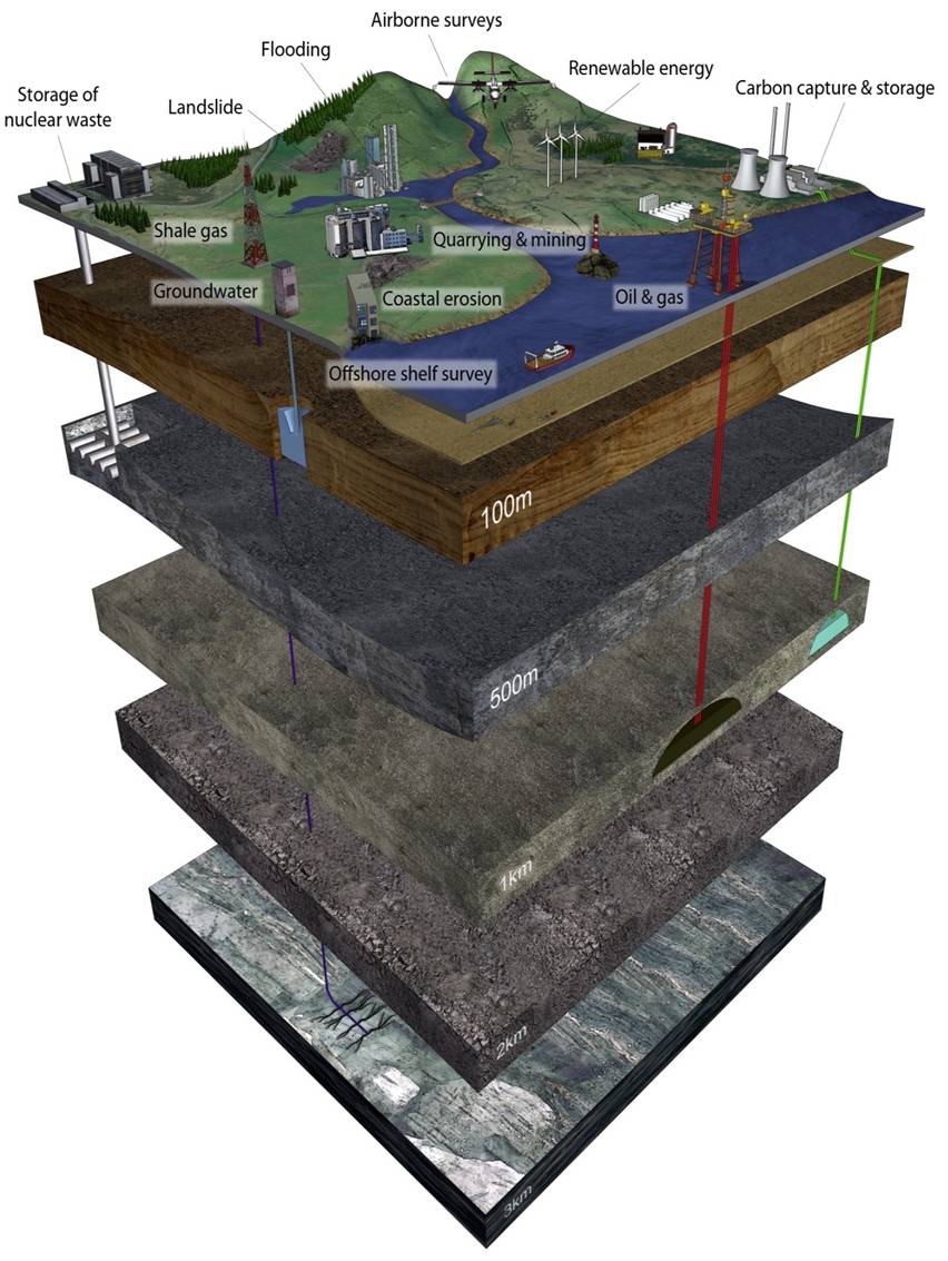
Demands on the subsurface (by the British Geological Survey)

Demands on the (sub)surface (by the British Geological Survey)

We do not currently have answers for these questions but are initiating and undertaking research in this area as well as highlighting the need for policymakers, scientists, academic and publics to negotiate the challenges the subsurface will face going forward.

Reference:

  1. DECC (2012). CCS Roadmap: Supporting deployment of Carbon Capture and Storage in the UK < www.gov.uk/government/uploads/system/uploads/attachment_data/file/48317/4899-the-ccs-roadmap.pdf > Accessed: 10/06/2015.

Funding opportunity for Early Career Researchers to attend GSA Baltimore

The Heritage Stone Task Group in southern Europe is a Task Group within the IUGS. In March, HSTG  had a proposal accepted as Project 637 of the International Geoscience Programme (IGCP 637). With this acceptance, IGCP 637 offered $US6,000 in 2015 to support conference participation.

HSTG has decided that this funding should be used in 2015 to support attendance to our session in the GSA Baltimore conference. Amounts not exceeding $US2000 will likely be available. We have been asked by the IGCP Secretariat to give preference to supporting scientists from developing countries or who are young or women scientists. Recipients will also be expected to make a conference presentation in our session, related to natural stones, architectonic heritage and related issues.

Early Career researchers who are interested should send a message showing interest and a short cv, with a potential title for the contribution in the HSTG session, to the HSTG secretary general Barry Cooper: Barry.Cooper@unisa.edu.au

Applicatons will be received up to 30 June 2015.

Please contact Dr Lola Pereira for further information (mdp@usal.es)

Down by the River: Environmental Impact of Energy Generation Along the Colorado River

In our hunt for energy, we turn in many directions, especially those that will affect the environment to a lesser extent than the conventional fossil fuels. Though renewable energy is a sustainable form of energy production – it is after all infinite – it does not always mean that this form of energy production is without impact.

In 1963 the Glen Canyon Dam was built across the Colorado River, running through the Grand Canyon. Doing so created Lake Powell and helped in the generation of hydroelectric power. By 1974, researchers discovered the impact the dam had further downstream along the Colorado River, with shrinking sandbars as they no longer were replenished by sediment trapped in Lake Powell, behind the dam. Since then, scientists have been trying to get insight into the possibility of controlled flooding of the river to maintaining, or growing, the number of sandbars in the Colorado River. A new High Flow Experimental Release (HFE) Protocol could be the solution. However, care needs to be taken to protect both the downstream eco-system, as well as ensuring sufficient power generation by the dam.

Read more in this week’s EOS article 🙂

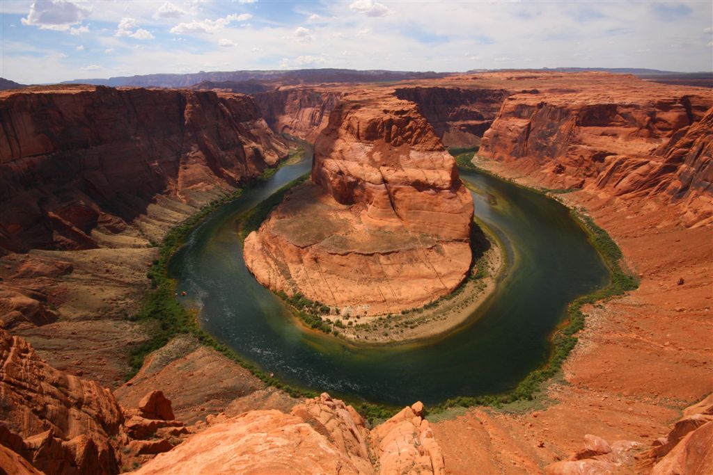
Colorado Horseshoe Bend (by Ioannis Daglis, taken from ImagGeo)

Colorado Horseshoe Bend (by Ioannis Daglis, taken from ImagGeo)

How a geophysical extreme event dramatically changed fieldwork plans – a personal account of the Gorkha Earthquake

by Viktor Bruckmana and Klaus Katzensteinerb
aCommission for Interdisciplinary Ecological Studies, Austrian Academy of Sciences, Vienna; bInstitute for Forest Ecology, University of Natural Resources and Life Sciences (BOKU), Vienna

Options for Integrated Forest Management in the Gaurishankar Conservation Area is the title of one of our ongoing projects with collaborating partners from Nepal, China and Austria. The Gaurishankar Conservation Area (GCA) covers 2.179 km² and was installed in 2010 by the Government of Nepal. It is located in Eastern Nepal bordering with Mt. Everest National Park in the East, Langtang National Park in the West and Tibet Autonomous Region of China in the North. Of the total area of GCA, 35% is covered by forest. The elevation ranges between 1000 and 7000m a.s.l., which leads to a complex ecosystem with 16 major vegetation types and high floral and faunal diversity. The region is home to approximately 60.000 people. Due to a long and complex settlement history, different ethnic and religious groups contribute to the outstanding cultural diversity of GCA. In addition, the entire region is rich in water resources and the catchment area of a number of rivers which are the source of some major ongoing and projected hydro-power projects.

Map of Gaurishankar Conservation area (GCA) including respective Village Development Committees (VDC’s) and localities within the Tamakoshi River valley that are mentioned in this post.

Map of Gaurishankar Conservation area (GCA) including respective Village Development Committees (VDC’s) and localities within the Tamakoshi River valley that are mentioned in this post (by NTNC, the National Trust for Nature Conservation, Lalitpur, Nepal).

Study aims

The aim of our proposed study was to assess land use and forest resources management in one of the remotest parts of the recently installed conservation area. Therefore, we suggested a 2-step approach. In the first step a participatory rural appraisal (individual and group interviews and group discussions on land use and livelihood, including mapping of resources and activities) gives background information on human-ecosystem interactions. In the second step we intended to set up a number of monitoring plots according to local conditions and the results from discussions and mapping of activities in terms of land use. Our aim was to involve stakeholders from the beginning since the results should be useful for these communities and not only for the sake of science. As such, the entire project concept fits very well to the EGU, Division Energy, Resources and the Environment because it is a nice example of interdisciplinary efforts in order to understand local systems of energy, resources and the implications on the environment.

Methods and approach

Participants of the project kick-off workshop in Kathmandu (by Prof. Dr. Klaus Katzensteiner)

Participants of the project kick-off workshop in Kathmandu (by Prof. Dr. Klaus Katzensteiner).

Our participatory approach started with a workshop in Kathmandu on 22nd of April 2015, where we invited important stakeholders from various governmental and institutional bodies to introduce the project and the respective aims. It was important to us to get a good overview on the impacts of land use restrictions and guidelines on the local communities since the establishment of GCA, as this would be the baseline assessment for our activities.

In a next step, we prepared a set of questions, including demographic and societal indicators as well as information about current land use, consequences of ongoing hydropower projects and to a certain extent future perspectives. On 23rd and 24th of April, we conducted a range of semi-structured group and individual interviews based on the prepared set of questions.

We conducted a set of semi-structured interviews in order to assess land management practices and the impact of new management policies since the Gaurishankar Conservation Area was set up in 2010 (by Dr. Viktor Bruckman)

We conducted a set of semi-structured interviews in order to assess land management practices and the impact of new management policies since the Gaurishankar Conservation Area was set up in 2010 (by Dr. Viktor Bruckman).

Baseline assessment

It turned out that large impact on societies, as well as land use is expected from the Upper Tamakoshi Hydropower Project (UTHP), representing the largest hydropower plant in Nepal with a capacity of 456MW. The construction site of the dam is located in the village of Lamabagar, approximately 7 km from the Tibetan border. In order to facilitate access to the construction site, a road was build and it has already considerable impacts. Formerly remote settlements are now connected to the road network and improvements in the sectors health, education and business opportunities were reported [1].

Agriculture on terraces and small-scale stock farming dominates in lower elevations. Litter is collected in forests and composted together with manure which serves then as natural fertilizer for agriculture.

The impressive Gaurishankar, on the Nepal-Chinese border is 7.134m high and serves as eponym for the respective conservation area. Typical land use practices are shown in the foreground with terrace farming and trees used as a source of fodder. Together it represents a kind of agroforestry (by Dr. Viktor Bruckman)

The impressive Gaurishankar, on the Nepal-Chinese border is 7.134m high and serves as eponym for the respective conservation area. Typical land use practices are shown in the foreground with terrace farming and trees used as a source of fodder. Together it represents a kind of agroforestry (by Dr. Viktor Bruckman).

Animal husbandry with Yaks and Chauri (hybrids between Yaks and local cattle) or goats dominates in higher altitudes where agriculture is unable to produce enough goods for survival. The practice of lopping (cutting green twigs and branches of trees as animal fodder), especially on Quercus species is a common practice throughout the entire region. In lower altitudes, one may find nice examples of agroforestry, i.e. the coexistence of fodder trees that are being regularly lopped and agricultural terraces. Life is difficult in these remote areas, the Gaurishankar Conservation Area Management Plan states that the average time of food security per year from own farm production ranges from 3.4 to 8.7 months [2] in different Village Development Committees (VDC’s, smallest political units in Nepal; Gaurishankar Conservation Area consists of 22 VDC’s). This means that the families rely on additional income in order to purchase food items for the duration of 3.3-8.6 months per year in the worst case.

Freshly collected Yartsa Gunbu (Ophiocordyceps sinensis) may provide between 30 and up to 70% of the annual family income (by Dr. Viktor Bruckman).

Freshly collected Yartsa Gunbu (Ophiocordyceps sinensis) may provide between 30 and up to 70% of the annual family income (by Dr. Viktor Bruckman).

Forests in the remote parts of the valley upstream of Lamabagar are more or less intact, and management seems to be relatively sustainable over the course of a few centuries, with the main non-timber forest products (NTFP’s) such as animal fodder from lopping, collection of litter, herbaceous plant species and medical plants as well as fuelwood and to some extent also construction wood. The upper tree line in this valley lies between 3600-3700m. Male family members usually seek for income opportunities in the capital, Kathmandu or further away in countries such as India, Qatar or Malaysia, while female members take care about agriculture and animal breeding. A unique source of income especially in this region is the collection of Yartsa Gunbu, the fruiting body of a fungus (Ophiocordyceps sinensis), parasitizing on the larvae moths on alpine pastures above the tree line. Approximately 30-60% of the annual family income may be earned from selling Yartsa Gunbu, which is especially demanded in Chinese traditional medicine as it is believed to cure cancer. Yartsa Gunbu is usually collected by teenagers and they typically spend a few days in the mountains at once. According to them, between 1500 and 4000 of them were in the mountains at the time we arrived Lamabagar as Yartsa Gunbu is only collected in certain seasons.

Lamabagar (2000m a.s.l.) lies on the flat riverbed of the Upper Tamakoshi River, which developed as a consequence of a massive landslide (probably earthquake-induced) in the past (by Dr. Viktor Bruckman).

Lamabagar (2000m a.s.l.) lies on the flat riverbed of the Upper Tamakoshi River, which developed as a consequence of a massive landslide (probably earthquake-induced) in the past (by Dr. Viktor Bruckman).

Lamabagar is located at 2000m a.s.l. and the starting point of our expedition since the road ends at the hydropower dam construction site. After having a good background impression of the current situation, we were prepared to leave from Lamabagar on the Morning of 25th of April. Our plan was to reach the Lapchi Monastery on 27th, while continuing interviews in the smaller settlements on the way. Lapchi Monastery is situated at the border to Tibet at around 3800m a.s.l. and it is one of the most important spiritual places in the entire Tibetian region [3]. We would have marked potential sites for setting up monitoring plots while proceeding towards Lapchi. On the way back and after discussing potential sites, we would have established some of the plots to conduct a biomass and species inventory according to a pre-defined protocol. In addition, we would have described soil profiles and taken samples for the determination of organic carbon stocks.

Fieldwork starts with hiking

The morning of 25th of April was not very convincing to start an exhausting hike since it was raining. However, at least it would not be as hot and therefore we would be able to proceed faster than initially expected. Our three porters came to our accommodation in the morning. We handed them over most of the scientific equipment and some of our food supplies. The larger share of our supplies was sent to the Lapchi Monastery by helicopter previously, and local porters were asked to carry those items to the settlements downstream. So we would have our food at each station where we planned to stay during our expedition. The porters asked us to hand them over more load as they are trained to easily carry 30kg or more. I decided to give them some of my bulky items, e.g. sleeping bag or mattress. The portable water filter, although relatively heavy, was with me since I was only carrying one liter of drinking water with me, certainly not enough for a whole day trek. The porters decided to take a breakfast and follow us later on as they would easily catch up with us before noon, as they told us. We started to hike towards Lumnang, which would be our destination on this first day. It is a small settlement of around 15 buildings and the last permanent settlement in this valley. All other settlements upstream are temporary and used during summer months (except Lapchi Monastery).

A view towards Lamabagar (downstream) after approx. two hours of hiking. Rhododendron arboretum is in full bloom, making the hike a wonderful experience despite the weather conditions (by Dr. Viktor Bruckman)

A view towards Lamabagar (downstream) after approx. two hours of hiking. Rhododendron arboretum is in full bloom, making the hike a wonderful experience despite the weather conditions (by Dr. Viktor Bruckman).

Although we faced constant drizzling rain, we were overwhelmed by the beauty of this remote region. Steep cliffs of metamorphosed sedimentary series (Tethys Himalaya within the Central Himalayan Domain) were dominating the first few hours of hiking. Unmanaged mixed deciduous forests with high diversity were situated along the streams and on ridges. At around 11:30 AM, we just passed probably the most difficult terrain with a number of steep, difficult and exhausting passages.

The view to the stupa at the river junction marks the entrance to the Lapchi river valley (by Prof. Dr. Klaus Katzensteiner).

The view to the stupa at the river junction marks the entrance to the Lapchi river valley (by Prof. Dr. Klaus Katzensteiner).

On the top of this, we were able to see a stupa that was built at the junction of Lapchi River and another stream from Tibet. From this point, the joint stream is called Tamakoshi River. We took a short rest at this magnificent place before descending to the entrance of the Lapchi River valley, characterized by steep cliffs of 300-400m on the Eastern side of the river and a densely forested slope on the western side, where the trail is located approx. 10-50m from the river. The weather started to change gradually as rain stopped and there were a few glimpses of sunlight.

The moment when everything changed completely

Rockfall from the opposite cliffs made our location a highly dangerous place (by Prof. Dr. Klaus Katzensteiner)

Rockfall from the opposite cliffs made our location a highly dangerous place (by Prof. Dr. Klaus Katzensteiner).

At 12:05 local time, the peaceful appearance suddenly stopped, as the ground beneath our feet, shrubs and bushes started to literally vibrate around us and the remaining water from the surrounding trees poured on us just like a strong rainfall event. After several seconds, vibrating turned into shaking and first rocks of the size of a football came down the slope on our side. After realizing it is actually an earthquake, we (I was together with my Nepalese colleague Prof. Mohan Devkota at this time, his student Puskar was somewhere about 50m ahead and Prof. Katzensteiner from BOKU University was in front) looked for a safe place while more and larger rocks came down. While hiding behind a tree which would hopefully protect us from rockfall and praying for the end of this nightmare, it turned out to be even worse. With amazingly loud sounds, similar to detonations, we realized that large pieces of rock and landslides came down at certain locations from the cliffs opposite of the river. These large rocks (with a size equal to small houses) smashed into the river, immediately braking up to several smaller pieces. These spread in all directions, felling entire trees on their destructive way.

 Seconds after the main tremor was over, everything was changed. The river color turned brown, dust and Sulphur smell was in the air and the path was destroyed by small landslides or rocks (by Prof. Dr. Klaus Katzensteiner).

Seconds after the main tremor was over, everything was changed. The river color turned brown, dust and Sulphur smell was in the air and the path was destroyed by small landslides or rocks (by Prof. Dr. Klaus Katzensteiner).

As this happened directly on our opposite and all around us was dust, falling trees and incredible noise, I was almost certain that this would be the last impressions of my life. But both of us were lucky, we survived this without a single scratch. Still hard to realize what just happened, we were immediately looking for our colleagues, but found only Prof. Katzensteiner, who was standing underneath an overhanging rock to protect himself from rockfall which still occurred as a consequence of constant aftershocks. He told that a Lama (monk) must have come down towards our direction and may be with the student who was among us during this event. However, there was no trace of them, despite loudly calling for them. A large rock of the size of a truck was lying right on the trail and we were all hoping that they were not buried under it. We were waiting a few minutes under this rock, as it was still too dangerous to look after our colleagues. Fortunately they came along the way, apparently not injured, after another five minutes or so. It turned out that they were running uphill when the rocks came down from the cliffs, in order to escape from the rock bullets from the river. The lama saved our student’s life as it turned out as he was almost hit by a large rock, which destroyed his water bottle that was attached to his back bag.

Luck in an unlucky situation

The lama guided us to a holy cave that was washed out by the river and which was only a few hundred meters away from the place where the earthquake hit us. But we started to become worried about landslides that might have blocked the river upstream and the destructive consequences of a potential flash flood. Therefore, we carefully observed the water level of the river that changed its color to dark brown in the meantime. After one hour or so we decided to leave the valley immediately, together with the lama, who knows the terrain very well. However, once we reached the point where we entered Lapchi valley at the river junction, we realized that the trail was gone due to a massive landslide and there was no opportunity to bypass this trail, even not with our experienced guide. Therefore he recommended hiking upstream to a meditation center where around 20 lamas meditate in tents underneath the (slightly overhanging) cliffs.

The retreat where lamas provided us with food and shelter (by Prof. Dr. Klaus Katzensteiner).

The retreat where lamas provided us with food and shelter (by Prof. Dr. Klaus Katzensteiner).

This place is about 2 hours hiking from Lumnang, the village where we intended to stay. The trail was partly destroyed by landslides so we had to somehow cross rather dangerous sections (while there were constant aftershocks), but finally we were able to reache the meditation place or retreat. The lamas kindly offered us milk tea and food, and in addition a place to sleep. What an incredible luck in our situation! We had no supplies with us and only relatively light equipment, no sleeping bags, mats etc.. The lamas told us that if we are lucky, we might be able to get a mobile signal at a certain location in the mountains, but local conditions allow a successful contact usually only in the morning at around 10:00 AM. We tried to call in the following morning and were successful, just a few seconds, but we were able to communicate the most important information that we are all safe, but we need a helicopter as we are unable to leave the valley. At this time, we did not know that this would be actually the only time when we were able to contact the outside world; we never again got a signal in the coming days, despite our desperate attempts. While we were not sure if and when we would be rescued (an old radio enabled us to receive AM stations from India, where we learned that this was a major incident), we were worried about our families since they probably didn’t know about our situation.

The footpath was completely destroyed and stones still falling down every now and then as a consequence of multiple aftershocks and the loose bedrock material in this region (by Assoc. Prof. Dr. Mohan Devkota).

The footpath was completely destroyed and stones still falling down every now and then as a consequence of multiple aftershocks and the loose bedrock material in this region (by Assoc. Prof. Dr. Mohan Devkota).

In fact, everyone was involved in planning our rescue mission, from our families to officials of our respective institutions, ministries, embassies to the local military camps. We just did not know what was going on. We were finally rescued after five days as a helicopter came into the valley and we quickly went to the next helipad (which was approx. 1 hour hiking from the place where we stayed). The helicopter was waiting there and brought us to the army camp in Charikot and returned one more time to provide the villagers from Lumnang (which is completely destroyed according to a number of reports from the lamas and inhabitants) with medicine and basic food items.

Tragic consequences

After five days, we were finally rescued by the helicopter and the nightmare was finally over for us. However, it still continues until today for the villagers who have lost their homes and many of them also family members and relatives (by Dr. Viktor Bruckman).

After five days, we were finally rescued by a helicopter and the nightmare was finally over for us. However, it still continues until today for the villagers who have lost their homes and many of them also family members and relatives (by Dr. Viktor Bruckman).

On the way out, we realized that landslides had wiped off large sections of the trail and there would have been only minor chances to escape from this valley for us. Approximately 80% of all building structures were destroyed. Later we unfortunately learned that one of our porters was killed by a landslide and another one was seriously injured. Only one of them managed to safely return to Lamabagar. Several groups of people (one group was heading towards Lapchi, we overtook them early in the morning, and another group of hydropower experts was heading towards Lamabagar) are still missing. Locals reported that there were many dead bodies on the river banks of Tamakoshi River upstream of Lamabagar, and 300 people collecting Yasarguma are still missing [4]. There were also a number of fatalities in Lumnang as reported by the lamas but the fact that the quake hit Nepal during daytime probably saved many lives as most of the people were staying outside.

Finally we have survived. However, our deepest condolences are with the family of the porter that has lost his life during our expedition (by Prof. Dr. Klaus Katzensteiner).

Finally we have survived. However, our deepest condolences are with the family of the porter that has lost his life during our expedition (by Prof. Dr. Klaus Katzensteiner).

Geophysical background

The April 25th Gorkha Earthquake was the largest one in the region since the Bihar quake in 1934. It measured 7.8 on the moment magnitude scale (i.e. the Richter scale) and the epicenter was located around 70km west of Kathmandu at approximately 15km depth [5]. In addition to the shallow quake, massive displacements occurred as observed by ESA’s Sentinel satellites [6] and there is evidence that Mt. Everest is shorter by about 2.5 cm since the earthquake [7]. Moreover, the earthquake was so intense that NASA was able to observe a disruption of the distribution of electrons in the ionosphere [8]. Despite the fact that nobody of us expected an earthquake, it was not really a surprise as a number of scientists, including Roger Bilham of University of Colorado, warned that crustal stresses are building up in Nepal [9].

On May 12th, 2015 days after all of us were back at home with our families, another intensive earthquake was recorded in Nepal, again as a consequence of thrust faulting. The USGS reported that the epicenter was just a few km away from the area where we were about to start our fieldwork [10]. It occurred along the same Main Himalayan Thrust where the initial earthquake happened only days before and is therefore considered as a large aftershock (M 7.3). Since then, we are unable to contact anybody in Lamabagar as the communication system has been apparently destroyed. The powerful aftershock caused further damages; virtually all remaining buildings collapsed.

What we have learned and how it influences our future activities

The question is, of course, what we have learned from this event and what are we going to do next. Certainly we will bring a satellite phone or at least an EPIRB (Emergency Position-Indicating Radio Beacon) with us whenever we are working in remote areas. Apparently we are unable to ignore the facts and continue with our initial project aim. Despite the fact that the area is currently inaccessible on land, we would probably not meet the communities’ needs if we stick to the initial ideas. Therefore we will carefully assess the current situation and subsequently develop a new proposal on how to support these remote villages on a long-term and sustainable basis. One approach can be to develop local forest resources, i.e. construction wood for reconstruction of buildings which are safer against earthquake disaster as compared to current building structures. In addition to this long-term support, we are desperately seeking for immediate support for the families of our porters, especially those of the porter who passed away, leaving behind two daughters and two sons, and the porter who was severely injured.

Please help us to support affected families

For the purpose of collecting donations, we opened an account at the University of Natural Resources and Life Sciences Vienna (BOKU). Funds will be collected in a transparent manner and directly used for supporting the porter’s families and the villagers of Lumnang, who have lost everything and they will most likely not receive help from other sources soon. We will facilitate support through the trustworthy Nepalese project partners (including full documentation) and the Lamas of Lapchi monastery and from the retreat where we were able to stay. Please help us to support this remote region; even a small contribution is very much appreciated. Our direct contacts ensure that 100% of the donations reach the target group.

Here are the account details for wire transfer:

Recipient: Universität für Bodenkultur Wien, Spenden IBAN: AT48 3200 0018 0050 0512 BIC: RLNWATWWXXX Payment reference: 7912000003

Payments via Credit Card are also possible (Master Card and Visa). Should you wish to pay per credit card, please send an e-mail containing your name, address, card number, expiry date and security code (3-digits) to c.hofer@boku.ac.at.

We thank you very much for your contribution!

***

References:
  1. Manandhar, R. (2014) Upper Tamakoshi a boon for locals. Retrieved from http://www.ekantipur.com/2014/02/01/national/upper-tamakoshi-a-boon-for-locals/384741.html [28.05.2015]
  2. NTNC (2013) Gaurishankar Conservation Area Management Plan 2013-2017. Narma Consultancy Pvt Ltd in association with Practical Solution Consultancy Pvt Ltd., Kathmandu, Nepal.
  3. Huber, T. (1997) Guidebook to Lapchi. In: Lopez, D.S. Jr. (Ed.) Religions of Tibet in Practice. Princeton Readings in Religions, Princeton University Press, Princeton, New Jersey, pp 120-134.
  4. Kathiwada, R. (2015) 300 Yarchagumba pickers missing in Dolakha. Retrieved from http://www.myrepublica.com/t20/item/20033-300-yarchagumba-pickers-missing-in-dolakha.html [28.05.2015]
  5. Sandiford, M., Rajendran, C.P. and Morell, K. (2015) The science behind the Nepal earthquake. Retrieved from http://theconversation.com/the-science-behind-the-nepal-earthquake-40835 [28.05.2015]
  6. DLR (2015) Update: Disaster relief – DLR provides aerial images of Kathmandu. Retrieved from http://www.dlr.de/dlr/en/desktopdefault.aspx/tabid-10081/151_read-13487/#/gallery/19391 [28.05.2015]
  7. Oskin, B. (2015) Mount Everest Shrank As Nepal Quake Lifted Kathmandu. Retrieved from http://www.livescience.com/50677-nepal-earthquake-radar-satellite-view.html [28.05.2015]
  8. Stallard, B. (2015) Nepal’s Earthquake was So Intense it Changed Both Land and Air, Says NASA. Retrieved from http://www.natureworldnews.com/articles/14489/20150504/nepals-earthquake-intense-changed-both-land-air-nasa.htm [28.05.2015]
  9. Bilham, R. (2004) Earthquakes in India and the Himalaya: tectonics, geodesy and history. Annals of Geophysics 47/2-3, pp839-858.
  10. USGS (2015) USGS Earthquake Hazards Program, M7.3 – 19km SE of Kodari, Nepal. Retrieved from http://earthquake.usgs.gov/earthquakes/eventpage/us20002ejl#general_summary [28.05.2015]