Words on Wednesday aims at promoting interesting/fun/exciting publications on topics related to Energy, Resources and the Environment. If you would like to be featured on WoW, please send us a link of the paper, or your own post, at ERE.Matters@gmail.com.
***
A recent Nature News Explainer by Chris Cesare describes how forecasters with the US National Oceanic and Atmospheric Administration (NOAA) say that the El Niño weather pattern developing in the Pacific Ocean could eventually rank among the strongest on record and could bring rain to California.
Cesare, C. 2015. Developing El Niño could be strongest on record:Event could bring rain to drought-stricken California and dry conditions to Australia. Nature News:Explainer. http://www.nature.com/news/developing-el-ni%C3%B1o-could-be-strongest-on-record-1.18184
Cesare writes that a strong El Niño — signalled by the periodic warming of ocean-surface temperatures in the equatorial Pacific — can lead to heavy rain in parts of North America and drier-than-normal conditions in Australia, Indonesia and parts of India. NOAA says that there is an 85% chance that the current El Niño will last through the first few months of next year, with its strength peaking in November or December.
If ocean-surface temperatures in the Niño-3.4 region (in the eastern equatorial Pacific) are between 0.5 to 1 °C above average during a three-month window, NOAA declares a weak El Niño. Forecasters label an El Niño as strong if it exceeds the average by 1.5 °C. NOAA projects that the current event could produce temperatures that are 2 °C higher than average, or more. The strongest El Niño on record occurred in 1997–98 and produced temperatures 2.3 °C above average.
This year the El Niño started unusually early — in March instead of June. This could be because warm waters left over from last year’s weak El Niño gave it a head start – this would be the second El Niño year in a row, following the weak El Niño that developed late last year. A similar El Niño double-header happened between 1986 and 1988, but forecasters predict that the current El Niño will become stronger than either of those two events.

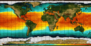
Elevated ocean surface temperatures in the eastern Pacific Ocean are a sign of El Niño. Image from http://www.nature.com/news/developing-el-ni%C3%B1o-could-be-strongest-on-record-1.18184, originally from NOAA
Importantly, El Niño could offer some relief to the US state of California, which is now in the fourth year of a historic drought. Forecasters say that there is a good chance that southern California will receive more rainfall than usual throughout the winter. In the past, very strong El Niños have also soaked the central and northern parts of the state. Although this is unlikely to “erase four years of drought”.
