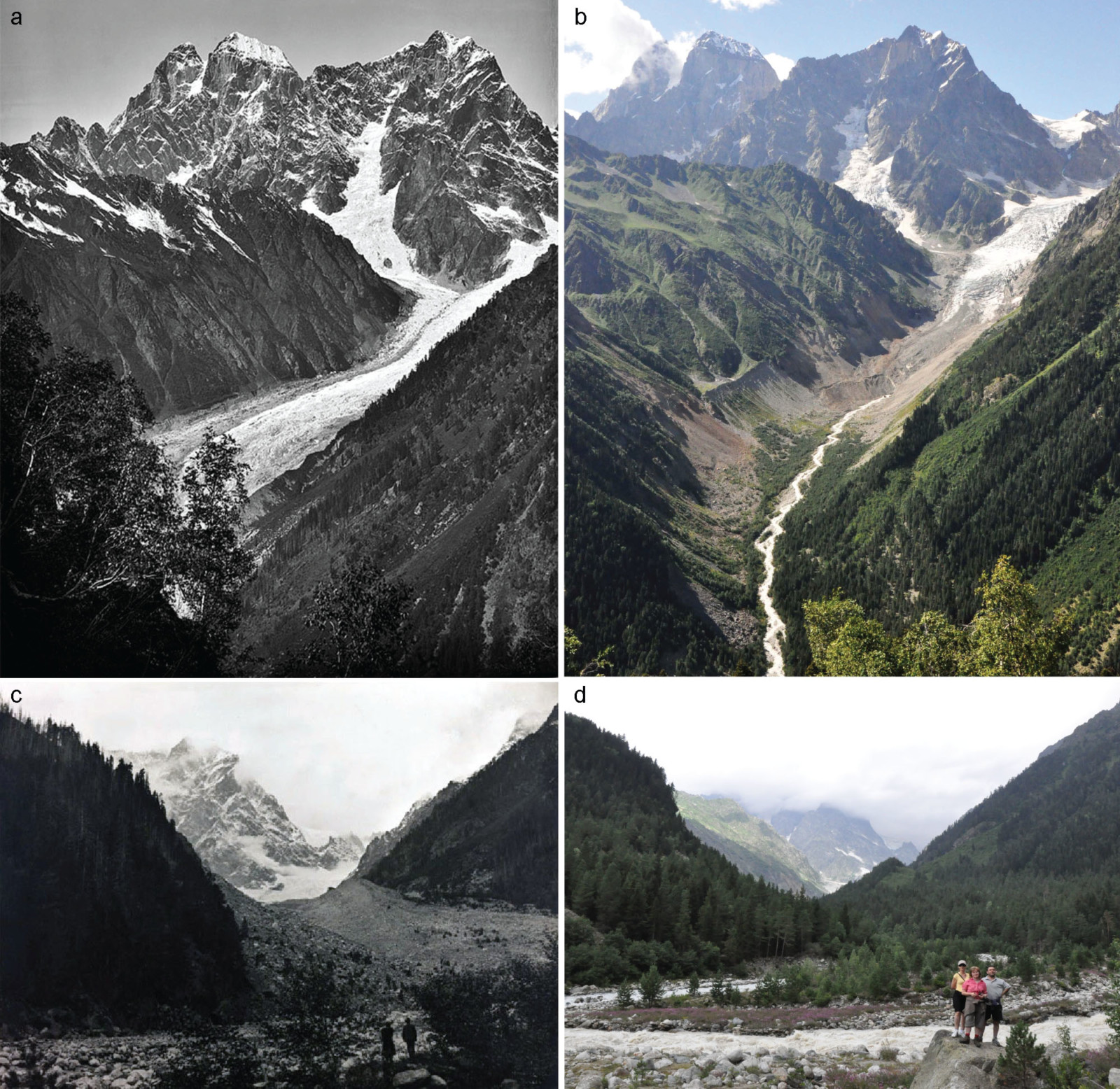
Figure 1 – Chalaati Glacier degradation between 1884 (a,c) and 2011 (b,d). Credit: Tielidze et al., 2020.
Chalaati Glacier is one of the largest glaciers in the Greater Caucasus and has undergone expansive mass loss. In this week’s blog post, Levan Tielidze tells us about Chalaati Glacier variations in the past centuries. His recent study was conducted based on surface exposure dating technique, dendrochronology (tree ring analysis), lichenometry, and satellite imagery. They found out that the Chalaati Glacier area decreased by 34% from 14.9 km2 to 9.9 km2 between 1810 and 2018. At the same time, the glacier shortened by 2.3 km. It is possible to identify the dramatic change of the glacier by comparing old and modern images (Fig. 1).
The Little Ice Age
The Little Ice Age (one of the coldest periods of the last millennia) is a documented cooling event that began around the 13th or 14th century and peaked between the mid-16th and mid-19th centuries. Quantifying glacier change during the Little Ice Age is important when attempting to understand regional climatic changes and can also help to improve the understanding of any predictions of future glacial changes.
Even though detailed records of glacier variations over the Little Ice Age on the Northern slope of Greater Caucasus (Russia) were recently published (e.g. Solomina et al., 2016), glacier changes were poorly documented on the southern slope of the Greater Caucasus (Georgia) (Fig. 2). For this purpose, Chalaati Glacier was selected on the southern slope of the Greater Caucasus in order to assess its variations since the Little Ice Age. We selected the Chalaati Glacier for several reasons:
- Chalaati is an example of a well-documented glacier with a wealth of different historical sources (e.g. maps, photographs, anecdotal evidences) that allow reconstruction of glacier length variations over the most recent centuries;
- Chalaati Valley is the best location on the southern slope of the Greater Caucasus where the well-preserved Little Ice Age moraines (accumulation of glacial debris) are covered by old conifer forest, which are useful for dendrochronological (tree ring dating) purposes.
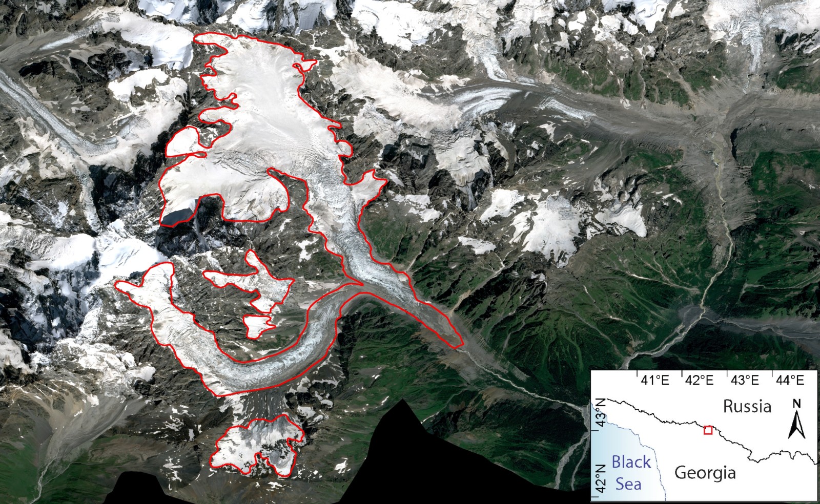
Figure 2 – Location of Chalaati Glacier. Credit: L. Tielidze. SPOT image from Azercosmos is used in the background.
Glaciers in Georgia
According to the latest inventory there are approximately 2000 glaciers with a total area of about 1200 sq. km in the Greater Caucasus. The Georgian side of this mountain range contains about 700 glaciers with a total area of about 370 sq. km (Tielidze and Wheate, 2018). To give you an idea of size, the glaciers of the Georgian Caucasus are about 2.5 times the size of the Principality of Liechtenstein. These glaciers play a significant role in the ecology and economy of Georgia. They provide a freshwater source that feeds rivers in the mountainous area. Georgian glaciers also have economic importance as a major tourist attraction with thousands of visitors each year. See our previous blog posts here and here for more information about the glaciers in this region.
Methodology that we used in this Study
For the first time in the history of glaciological studies of the Georgian Caucasus, cosmogenic surface exposure dating technique such as Beryllium-10 (a radioactive isotope 10Be) was applied. Surface exposure dating is a collection of geochronological techniques for estimating the length of time that a rock has been exposed at or near Earth’s surface.
The age of moraines was also determined by tree-ring analysis (dendrochronology technique). This technique is the scientific method of dating tree rings to the exact year they were formed.
In addition, lichenometry was used as a supplementary tool to determine the relative ages of glacial landforms. Lichenometry is a method of geochronologic dating that uses lichen growth to determine the age of exposed rock.
Furthermore, the large-scale topographical maps (1887, 1960) were used along with satellite imagery – Corona (no, not the pandemic), Landsat, and Sentinel. Repeated photographs were used to identify the glacier extent in the late 19th century.
Chalaati Glacier Change since the Little Ice Age
Even with all these methods, it was still difficult to assess the age of the oldest moraine of the Chalaati Glacier because of the limited number of samples. However, our results suggest that the beginning of the Little Ice Age occurred ~730 years ago (~1290 A.D.). The dendrochronology and lichenometry measurements show that the Chalaati Glacier also had a second peak in maximum size about 210 years ago (~1810 A.D.).
From 1810 through 2018 the glacier area decreased by approximately 34% from 14.9 km2 to 9.9 km2, while its length shortened by ~2.3 km. The retreat rate was uneven: it peaked in 1940-1970, and 2000-2018 while the rate was slowest in 1910–1930. The terminus elevation (the end of a glacier at any given point in time) rose from ~1620 m to ~1980 m above sea level in ~1810–2018. The newly created 4D animation map clearly shows this degradation process (Fig. 3).
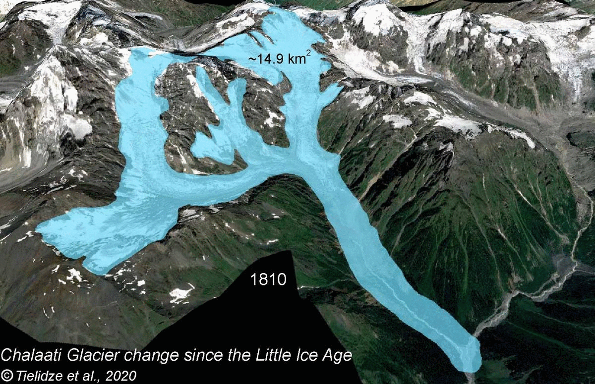
Figure 3 – Chalaati Glacier Change since the Little Ice Age. Credit: L. Tielidze.
The length changes of Chalaati Glacier are quite similar to other Caucasus glaciers, such as Tsey Glacier (Russia) over the past two centuries (e.g. Solomina et al., 2016). But rates are quite different to those observed in the Mer de Glace Glacier (France), which had several phases of ice loss and gain since the beginning of the 19th century (e.g. Zumbühl et al., 2008) (Fig. 4). Even though this study provides more information on last portion of Holocene Glaciation, we need more data collection, observations, and enhanced chronology from Chalaati and other glaciers in Georgian Caucasus in order to be more robust.

Figure 4 – Length changes for the Chalaati Glacier compared with Tsey Glacier in the northern Greater Caucasus (Russia) and Mer de Glace Glacier in the French Alps. Credit: Tielidze et al., 2020.
Chalaati is one of the most frequently visited glaciers in Georgia due its close location to the road, gentle valley inclination and low position of the terminus. Today this valley is used for the construction of hydropower (electricity generated by water flow). Water and debris from Chalaati Glacier drain into a reservoir, which is used by the local community. Therefore, studies like this are important for scientific and social reasons.
Further reading
- Does debris cover offset glacier retreat in the Greater Caucasus?
- Climate Change & Cryosphere – Caucasus Glaciers Receding
- Tielidze L.G., Solomina O.N., Jomelli V., Dolgova E.A., Bushueva I.S., Mikhalenko V.N., Brauche R., ASTER T. Change of Chalaati Glacier (Georgian Caucasus) since the Little Ice Age based on dendrochronological and Beryllium‑10 data. Ice and Snow. 2020;60(3):453-470. doi.org/10.31857/S2076673420030052.
- Tielidze, L. G., & Wheate, R. D. (2018). The Greater Caucasus Glacier Inventory (Russia, Georgia and Azerbaijan). The Cryosphere, 12(1), 81-94, doi: 10.5194/tc-12-81-2018.
- Solomina O.N., Bushueva I., Dolgova E., Jomelli V., Alexandrin M., Mikhalenko V., Matskovsky V. Glacier variations in the Northern Caucasus compared to climatic reconstructions over the past millennium. Global Planetary Change. 2016, 140: 28–58. doi.org/10.1016/j.gloplacha.2016.02.008.
- Zumbühl, H.J., Steiner, D., Nussbaumer, S.U., 19th century glacier representations and fluctuations in the central and western European Alps: an interdisciplinary approach. Glob. Planet. Chang. 2008. 60 (1), 42–57. doi.org/10.1016/j.gloplacha.2006.08.005.
Edited by Jenny Turton

Levan Tielidze is a PhD student at Antarctic Research Centre and School of Geography, Environmental and Earth Sciences, Victoria University of Wellington. His field of research is modern glaciers and glacial-geomorphological studies of the mountainous areas in the Late Quaternary. Contact email: tielidzelevan@gmail.com
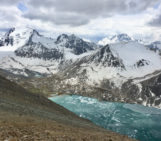
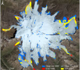
![Aerial image showing the climate change impact on small glaciers in the central Greater Caucasus, Georgia. Slopes are extensive deposits of moraines and loose rock debris, left behind by retreating glaciers. A small glacial lake (near the center-bottom of the image) fed by meltwater from the surrounding ice and snow was developed after glacier retreat [Credit: Levan Tielidze].](https://blogs.egu.eu/divisions/cr/files/2025/06/Fig0-161x141.jpg)