Loess is a silt-sized, aeolian sediment that was produced in large quantities in past geological eras of mid-latitude Europe and Asia, among others (Fig. 1). It is used in Quaternary science to infer about past climatic and environmental conditions. Generally, layers of loess formed during cold and dry periods, while soils formed within/on top the loess during warmer and wetter periods. These soils get buried again under a new loess layer once the warmer period is over. Since these soils are ‘old’ soils, which reflect characteristics of past climatic conditions, they are called paleosols. For scientific purposes these so-called ‘loess-paleosol sequences (LPS)’ are investigated. One such example is presented in our previous blog post. To learn more about why and how loess and paleosols are formed, have a look at this post. Due to their vast distribution, e.g. Europe, Asia, and elsewhere, numerous loess-paleosol sequences have been investigated. To understand the formation of LPS, it is important to know their occurrence, geomorphological setting, and potential source regions. Therefore, visualization of the distribution of loess and other Quaternary sediments using maps and paleomaps can assist in understanding the context behind the investigated LPS and their location in relation to potential source areas.
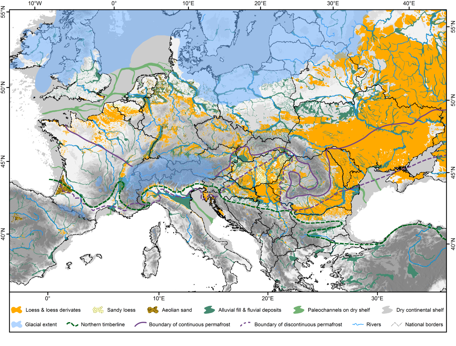
Figure 1: The new European loess map [1] shows different categories of aeolian and alluvial and fluvial Quaternary deposits, as well as the extent of glaciers [2], the northern timberline [3], boundaries of permafrost [see 1], and continent’s extent [4] at lower sea levels during the last glacial maximum.
Previous maps and mapping problems
The first European loess maps were presented by Grahmann (1932) [5] and Fink et al. (1977) [6]. The most commonly used digital loess map is the one published by Haase et al. (2007) [7]. These maps are based on geological, geomorphological, and pedological (field) mapping. More recently, Bertran et al. (2016) [8] generated a map of European Pleistocene aeolian deposits that is based on topsoil textural data from the LUCAS (Land Use and Cover Area frame Statistical survey) database. Another interesting approach is a global distribution map with a focus on Chinese deposits, which also investigates provenance and transport pathways of major loess areas and discusses their genesis [9].
A general problem in mapping is the question of data quality, data availability, and scale. Most maps are either very detailed on a local scale or are presented at a larger scale and lack precision. To circumvent this issue, one can combine high-resolution national datasets, although this often leads to artificial breaks at the borders that need to be evaluated and corrected [10-11].
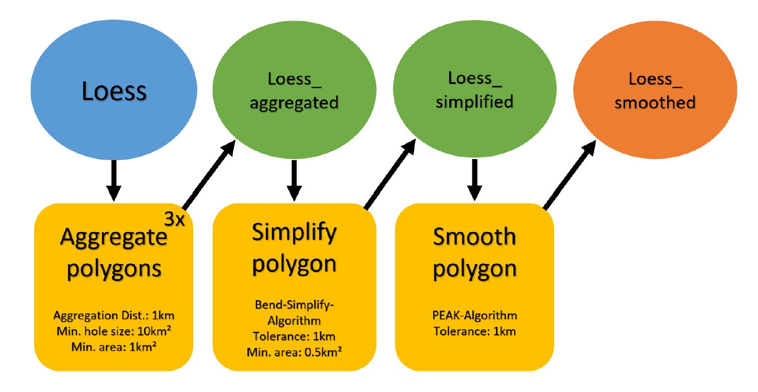
Figure 2: The five-step algorithm ArcGIS tool used for aggregation, simplification, and smoothing [1].
A new paleomap is born – source data and mapping
For our new European loess map (Fig. 1), we compiled geodata from 27 countries. Geological, geomorphological, and pedological data was processed and unified to create a seamless map of the distribution of Late Pleistocene aeolian sediments and their potential sources. Most of the time, printed maps were scanned, georeferenced, and vectorized. To avoid visual discontinuities derived from differing scales of source data, we used an algorithm to aggregate, simplify, and smooth the vector data (Fig. 2). In our paper [1], we further present a review of European loess deposits and their characteristics that can be used to give an overview of a specific region.
Moreover, we investigated differences between the regional loess distribution and characteristics and sorted them into 6 domains and 17 subdomains (Fig. 3). For this subdivision we applied the following criteria:
- Potential silt production areas, such as continental ice sheets and their surroundings, as well as mountainous areas;
- Affiliation to river catchments, as rivers are important silt-transport agents;
- Palaeoenvironmental conditions influencing the loess formation, preservation, and transformation. These include, e.g., the occurrence and characteristics of permafrost features.
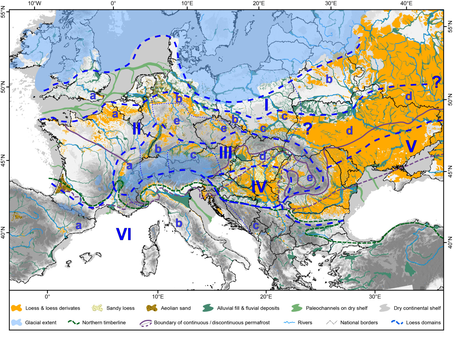
Figure 3: The loess distribution in Europe was divided into 6 major domains: I) Weichselian marginal or protogenetic zone; II) Northern European loess belt; III) Loess adjacent to Central European high-altitude mountain ranges; IV) Middle Danube loess; V) Pontic East European loess; IV) Mediterranean loess. Subdomains are indicated by letters a-e (see [1]). Figure from [1].
The main loess domains in Europe are the northern European loess belt (domain II), the loess adjacent to Central European high-altitude mountain ranges (domain III), the Middle Danube Basin loess (domain IV), and the Pontic East European loess (domain V). Less extensive loess covers are found in the protogenetic zone north of the northern European loess belt (domain I) and the Mediterranean (domain VI).
Once digitized into a geographical information system (GIS), the geodata of the loess map can be analyzed statistically (e.g. surface area and elevation), and visualized more easily, for example in form of 3D images. One of the images presented in the article is depicted in Figure 4 and gives an overview of the distribution of loess, Late Pleistocene, and Holocene fluvial deposits of the Tulln Basin in Lower Austria. The locations of important loess-paleosol sequences are also depicted. Since the used shapefiles are available online [12], everyone can use the data easily to create similar images.

Figure 4: The 3D image of the distribution of loess, sandy deposits, the Late Pleistocene fluvial deposits, and Holocene floodplain of the Tulln Basin in Lower Austria, after [1].
What can we learn from the new loess map and the review of European LPS?
Generally, the distribution of loess and formation of LPS were controlled by paleoclimatic condition, relief, and the distance to potential source areas such as large river systems. Past continental ice sheet dynamics and changes in the exposed North Sea shelf also played an important role. The differences between the deposits in the six European loess domains are the result of complex and changing paleoenvironmental conditions and related geomorphological processes across the continent. The new map and the review of European loess deposits help us to understand the complicated interplay of silt availability, climatic regimes, vegetation, and permafrost dynamics which influences the formation, preservation, and post-depositional alterations of loess better. The new findings can be applied to different temporal and especially spatial scales. These relatively simple cartographic visualizations enable us to better understand past environmental fluctuations in Europe.
We hope that this post gave you a brief overview of our work in GIS mapping of loess distribution. If you want to learn more about the loess distribution in Europe in detail please have a look at our article and don’t forget to download our shapefiles here.
This post has been edited by the editorial board.
References
[1] Lehmkuhl, F., Nett, J.J., Pötter, S., Schulte, P., Sprafke, T., Jary, Z., Antoine, P., Wacha, L., Wolf, D., Zerboni, A., Hošek, J., Marković, S.B., Obreht, I., Sümegi, P., Veres, D., Zeeden, C., Boemke, B.J., Schaubert, V., Viehweger, J., Hambach, U., 2021. Loess landscapes of Europe - mapping, geomorphology, and zonal differentiation. Earth-Science Reviews 215, 103496. https://doi.org/10.1016/j.earscirev.2020.103496.

[2] Ehlers, J., Gibbard, P.L., Hughes, P.D., 2011. Quaternary Glaciations - Extent and Chronology. Elsevier, Amsterdam.

[3] Grichuk, V.P., 1992. Main types of vegetation (ecosystems) for the maximum cooling of the last glaciation., in Frenzel, B., Pecsi, B. Velichko, A.A. (Eds.): Atlas of Palaeoclimates and Palaeoenvironments of the Northern Hemisphere. NQUA/Hungarian Academy of Sciences, Budapest, pp. 123–124.

[4] Willmes, C., 2015. LGM sea level change (HiRes), CRC806 database, Collaborative Research Centre 806.

[5] Grahmann, R., 1932. Der Löss in Europa, Mitteilungen Gesellschaft für Erdkunde. Duncker & Humblot, Leipzig.

[6] Fink, J., Haase, G., Ruske, R., 1977. Bemerkung zur Lößkarte von Europa 1:2,5 Mio. Petermanns Geographische Mitteilungen 2, 81–97.

[7] Haase, D., Fink, J., Haase, G., Ruske, R., Pécsi, M., Richter, H., Altermann, M., Jäger, K.-D., 2007. Loess in Europe—its spatial distribution based on a European Loess Map, scale 1:2,500,000. Quaternary Science Reviews 26, 1301–1312. https://doi.org/10.1016/j.quascirev.2007.02.003.

[8] Bertran, P., Liard, M., Sitzia, L., Tissoux, H., 2016. A map of Pleistocene aeolian deposits in Western Europe, with special emphasis on France: Pleistocene aeolian deposits in western Europe. Journal of Quaternary Science 31, 844–856. https://doi.org/10.1002/jqs.2909.

[9] Li, Y., Shi, W., Aydin, A., Beroya-Eitner, M.A., Gao, G., 2020. Loess genesis and worldwide distribution. Earth-Science Reviews 201, 102947. https://doi.org/10.1016/j.earscirev.2019.102947.

[10] Lehmkuhl, F., Bösken, J., Hošek, J., Sprafke, T., Marković, S.B., Obreht, I., Hambach, U., Sümegi, P., Thiemann, A., Steffens, S., Lindner, H., Veres, D., Zeeden, C., 2018. Loess distribution and related Quaternary sediments in the Carpathian Basin. Journal of Maps 14, 661–670. https://doi.org/10.1080/17445647.2018.1526720.

[11] Lehmkuhl, F., Pötter, S., Pauligk, A., Bösken, J., 2018. Loess and other Quaternary sediments in Germany. Journal of Maps 14, 330–340. https://doi.org/10.1080/17445647.2018.1473817.

[12] All shapefiles created for the European loess maps are available under DOIs: 10.5880/SFB806.56, 10.5880/SFB806.57, 10.5880/SFB806.58, 10.5880/SFB806.59, 10.5880/SFB806.60, 10.5880/SFB806.61.
Yang He
My name is Yang He, a faculty member at Chengdu University of Information Technology. I am writing to inquire about the possibility of obtaining GIS shapefiles that map the distribution of loess in Europe. This data would be greatly appreciated for my ongoing analysis of global loess deposits.