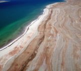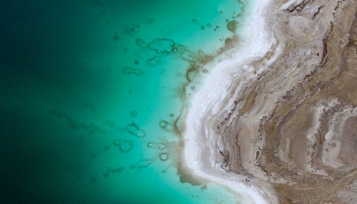
This beautiful aerial image (you’d be forgiven for thinking that it was a watercolour) of the Dead Sea was captured by a drone flying in 100m altitude over its eastern coastline.
Climate change is seeing temperatures rise in the Middle East, and the increased demand for water in the region (for irrigation) mean the areas on the banks of the lake are suffering a major water shortage. As a result, the lake is shrinking at an alarming rate. Currently, it is shrinking by over 1m/year. The image was captured as part of a survey in the wider project DESERVE (Kottmeier et al. 2016) addressing the environmental changes accompanying the lake level drop.
In this case, the special focus is to look for e.g. submarine springs or other geomorphological evidence in the shallow lake water that can later turn into hazardous sinkholes (cf. recent publication on that topic Al-Halbouni et. al. 2017). Learn more about the environmental challenges and geohazard risks the region faces in this December 2016 Imaggeo on Mondays post.
The round features see in this image, nevertheless have been identified as salt accumulations following basically the sinusoidal shoreline.
The different colours of the lake indicate water of varying densities, e.g. fresh water floating on top of saltier water and possible sediments inside.
The shoreline appears with different colours each year depending on the sediment mud & evaporite material. Each line represents the retreat of a given year!
[Editor’s note: this image was a finalsit in the 2017 Imaggeo Photo Contest]
By Laura Robert and Djamil Al-Halbouni of the German Research Center for Geosciences, Physics of the Earth, Potsdam, German
Imaggeo is the EGU’s online open access geosciences image repository. All geoscientists (and others) can submit their photographs and videos to this repository and, since it is open access, these images can be used for free by scientists for their presentations or publications, by educators and the general public, and some images can even be used freely for commercial purposes. Photographers also retain full rights of use, as Imaggeo images are licensed and distributed by the EGU under a Creative Commons licence. Submit your photos at http://imaggeo.egu.eu/upload/.