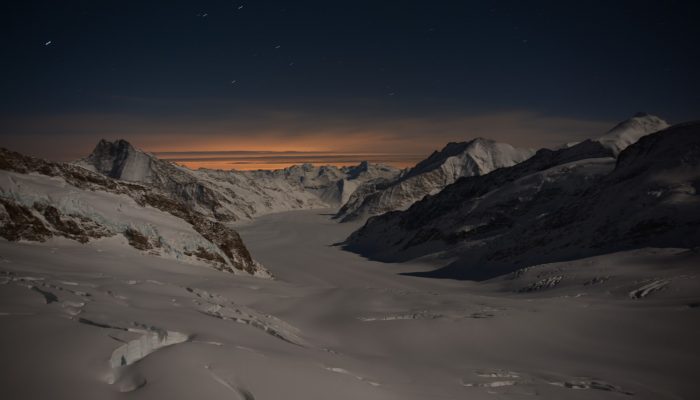
The high peaks of the Alps are always awe inspiring, but this midnight shot, captured by Alessandro Lechmann, a PhD student at the Institute of Geological Sciences at the University of Bern, further enhance their fragile beauty. With a warming climate threatening snow availability to even the highest peaks, it has never been more important to appreciate the importance of the glaciers which drape the mountain slopes.
This photograph shows a view from the Jungfraujoch (a saddle in the Bernese Alps, connecting the two four-thousander peaks Jungfrau and Mönch, at an elevation of 3,466 metres above sea level) towards the south-east down the Jungfraufirn (an arm of the Great Altesch Glacier).
Originating amidst three of the most famous mountains of the Swiss Alps (Eiger, Mönch and Jungfrau), this glacier flows southwards towards the Concordiaplatz, where it merges with the Ewigschneefäld and the Great Aletschfirn into the Great Aletsch Glacier. Even today, despite reports of receding glaciers in the Alps, it forms the largest and longest Alpine glacier.
In the countries surrounding the Alps, glacial landforms dominate the landscape. From drumlins, moraines (accumulations of glacial debris) and overdeepenings in the foreland to U-shaped valleys (Lauterbrunnen is a marvellous example) and cirques in mountainous regions. Although retreating at rates not seen previously, these glaciers carved the face of central Europe during the last glacial-interglacial cycles.
The building of the railway to the Jungfraujoch research station started in 1896 and was completed in 1912; an impressive feat considering the limited technology before the First World War. Perched precariously 3500 m above sea level, the research station (known for its prominent sphinx observatory), has contributed significantly to the understanding of the atmospheric sciences, glaciology and cosmic ray physics.
The ridge which the Jungfraujoch is built on, marks the northern margin of the exposed crystalline core of the Alpine orogeny. Interestingly, this mountain ridge, in addition to being a geological boundary, is also a major watershed. Rain that falls north, flows via the Aare into the Rhine, which eventually discharges into the North Sea. Precipitation on the southern flank and melt water from the Jungfraufirn, on the other hand, joins the Rhone in the Valais valley, that ends up in the Mediterranean Sea. This highlights the importance of Alpine glaciers as a water stores which continue to provide water throughout the year.
By Alessandro Lechmann PhD student at the Institute of Geological Sciences at the University of Bern
Imaggeo is the EGU’s online open access geosciences image repository. All geoscientists (and others) can submit their photographs and videos to this repository and, since it is open access, these images can be used for free by scientists for their presentations or publications, by educators and the general public, and some images can even be used freely for commercial purposes. Photographers also retain full rights of use, as Imaggeo images are licensed and distributed by the EGU under a Creative Commons licence. Submit your photos at http://imaggeo.egu.eu/upload/.


