Living Planet Symposium
Between the 9th and 13th May, Prague played host to the European Space Agency’s (ESA) fourth Living Planet Symposium. The event, the largest in its history with over 3300 attendees, brought together the earth observation community across multiple disciplines to discuss significant scientific results and the future developments of earth observation missions. Earth Observation of the Cryosphere over the last few decades has revolutionised our understanding of these regions, allowing us to monitor and assess ice sheet dynamics at unprecedented spatial and temporal scales.
ESA & Observation of the Cryosphere
The role of Earth Observation in Cryospheric sciences is set to increase further thanks to the European Commission and ESA Copernicus program; a series of satellites called Sentinels which all feature different sensor instrumentation, allowing researchers to monitor various aspects of the Earth System. The program will consist of 6 separate sentinel missions and will allow us to measure various Ice Sheet and Glacier dynamics continuously at a high temporal resolution. In addition, the Earth Explorer mission CryoSat-2 has been transforming our knowledge of the polar regions since it’s launch in 2010.
As a result, the conference had a wide range of exciting scientific results related to the Cryosphere from these missions; ranging from data products to be used by the community to the exploitation of mission data to further our knowledge of key processes and outstanding scientific questions.
Don’t worry if you weren’t able to make the symposium, as this post will highlight a selection of interesting results and the impact they will have on Cryospheric research!
CryoSat-2: Transforming Knowledge of the Cryosphere

CryoSat-2, an ESA Earth Explorer satellite that carries onboard a radar altimeter to measure ice elevation (Credit : ESA – P. Carril)
CryoSat-2 is the ESA Earth Explorer radar altimetry mission dedicated to monitoring changes in surface elevation of earth’s ice sheets, sea-ice thickness and extent; which it has been routinely monitoring since November 2010. The combination of its unique polar orbital characteristics and novel dual antenna interferometric mode of operation has allowed it to overcome many of the issues associated with previous altimetry missions over ice sheets.
Major results from CryoSat-2 included the application of swath processing techniques to the interferometric data to dramatically increase the number of surface elevation measurements available to researchers (Gray et al, 2013). Traditionally, the radar instrumentation would record a single elevation measurement at the point of closest approach (POCA) to the satellite. However, this technique analyses the whole radar return to produce measurements across the satellite footprint. By exploiting this increased data density it allows researchers to investigate ice sheet changes at much finer spatial and temporal resolution, allowing for an increase in the range of scientific questions the satellite is able to address. Examples of this include glacier thinning as a result of surging events that have previously occurred on time scales not possible to be captured by the satellite. It will also allow us to get a more complete picture of mass balance using the altimetry method.
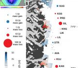
Ice-shelf thickness in Antarctica
Furthermore, a contemporary continental ice shelf thickness dataset (Chuter and Bamber, 2015) derived from CryoSat-2 was presented; which provides large accuracy improvements over the previous ERS-1 derived dataset (Griggs and Bamber, 2011), particularly in the grounding zone, a key region for monitoring ice sheet stability. The results from this work will allow the community to improve accuracy in mass balance estimations from the input-output method, sub-ice shelf ocean modelling and for parameterisations in ice sheet models.
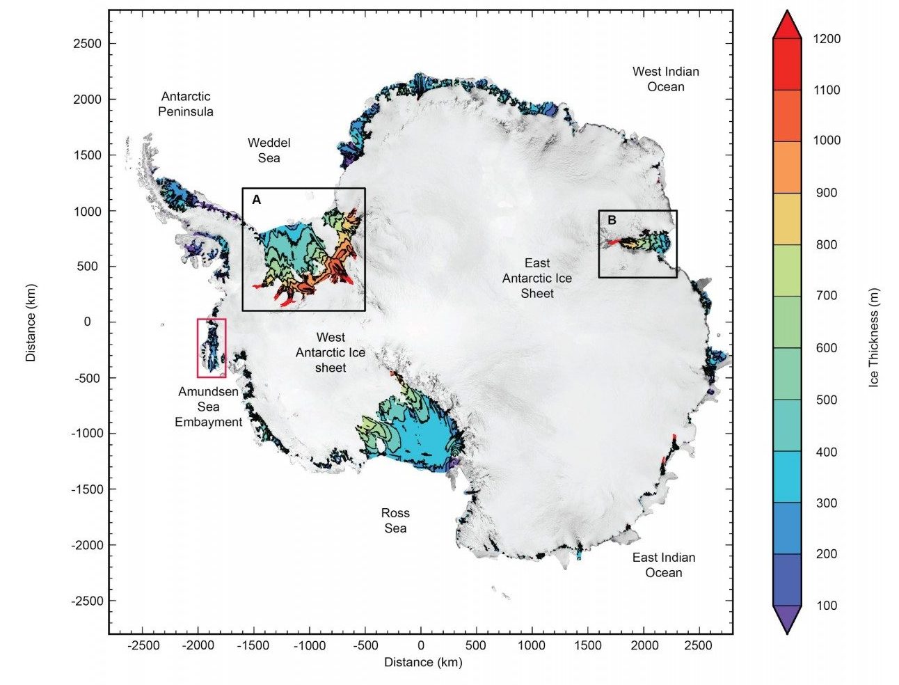
Antarctic ice shelf thickness Derived from CryoSat-2 radar altimetry (Credit: subset of fig S1 from Chuter and Bamber, 2015).
Monitoring sea ice
Sea ice monitoring is also a key mission objective, with the satellite already delivering on these aims through studies of continuous monitoring of the Arctic Sea Ice over the past five years. Work presented at the symposium by Rachel Tilling (CPOM/University College London) makes use of the Near Real Time data products from ESA to deliver knowledge of sea ice thickness and extent as quick as two days after data acquisition, providing benefits to the shipping industry in addition to aiding arctic climate predictions (see also Tilling et al, 2015).
Antarctic mass balance
For the Antarctic ice sheet, mass balance estimates obtained from altimetry, gravimetry, and mass-budget methods can yield conflicting results with error bars that do not always overlap.
Some of these techniques use models to isolate and remove the effects of glacio-isostatic adjustment and surface mass balance (SMB) processes, introducing another source of uncertainty which is hard to quantify.
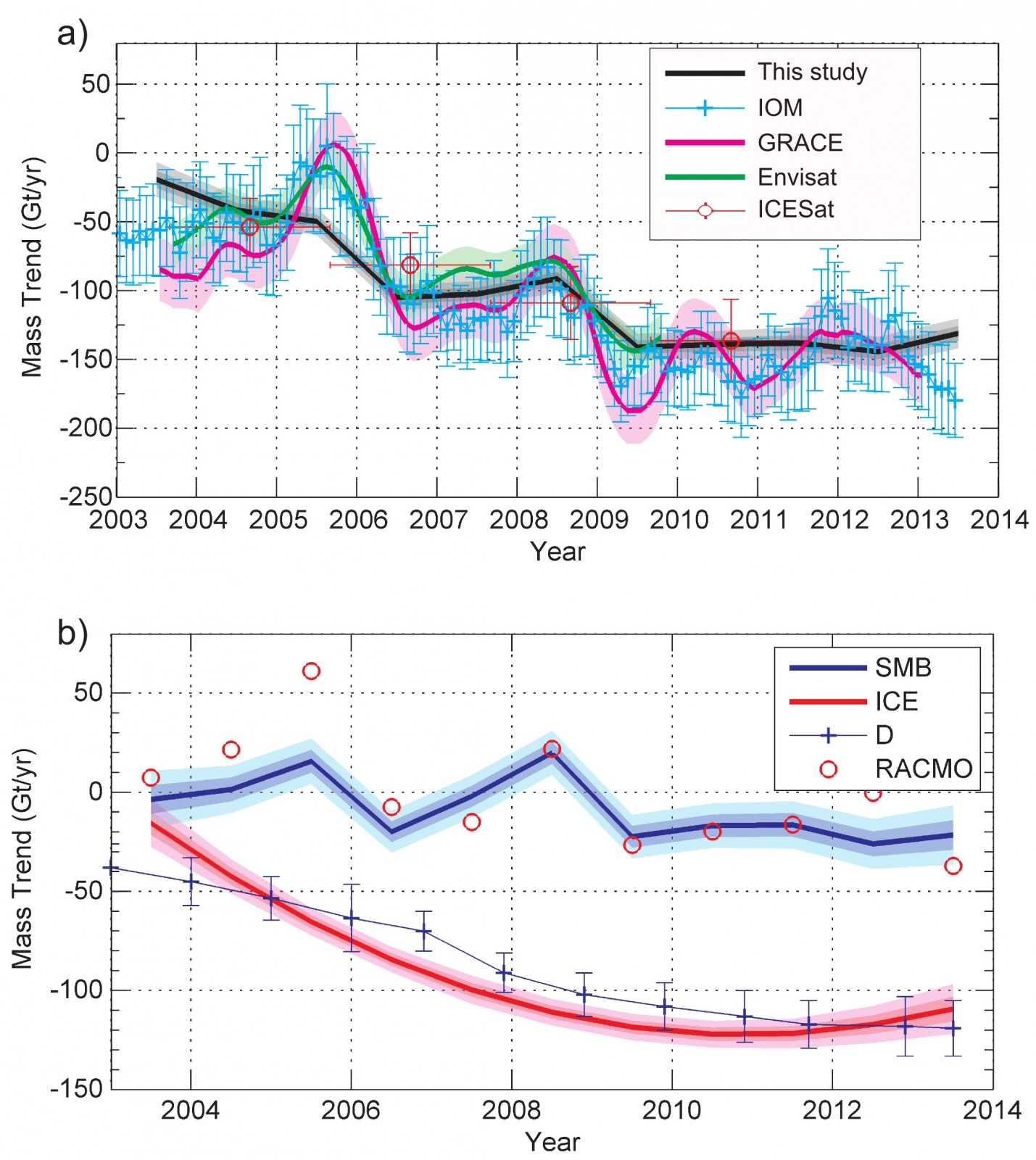
a) Estimates of mass balance for the Amundsen Sea Embayment sector in West Antarctica from different techniques, including estimates from the RATES project. [IOM = Input-Output Method] b) Estimates of the mass loss due to ice dynamics (red) and Surface Mass Balance (SMB — blue) for the Amundsen Sea Sector, compared with modeled values from RACMO2.3 (red dots) and ice discharge (D — blue line) (Credit: fig 9 from Martín-Español et al. 2016)
To address both these issues, the RATES project presented a statistical modelling approach to the problem (Martin-Español et al., 2016). They combined the observational data (including satellite altimetry, GRACE, GPS and InSAR), and used prior information to separate out the mass balance signal into its main components. For instance, we know that the glacio-isostatic adjustment has a large spatial length-scale, but changes in ice dynamics may vary from one glacier to the next. We thus can `look’ for these components within the data and attribute them to the correct process. For the period 2003-2013, they estimated a mean mass balance rate of -82±23 Gt/yr with a sustained negative mean trend of dynamic imbalance to which West Antarctica is the largest contributor, mainly triggered by high thinning rates of glaciers draining into the Amundsen Sea Embayment. The Antarctic Peninsula has experienced a dramatic increase in mass loss in the last decade following the destabilization of the Southern Antarctic Peninsula. The total mass loss is partly compensated by a significant mass gain in East Antarctica due to a positive trend of SMB anomalies.
4th Cryosat User workshop
In addition to major scientific results and products, the conference combined with the 4th CryoSat User Workshop, bringing together users from all cryospheric disciplines to discuss a variety of issues such as: Product Calibration and Validation campaigns, future data product releases and further serving the needs of the scientific community. In addition, with the satellite currently being operated beyond in it’s initial commissioning timespan, initial discussions were held regarding whether there would be the possibility of a follow up and the form it could possibly take.
Sentinel 1A/B – A New Era for Ice sheet Velocity Mapping
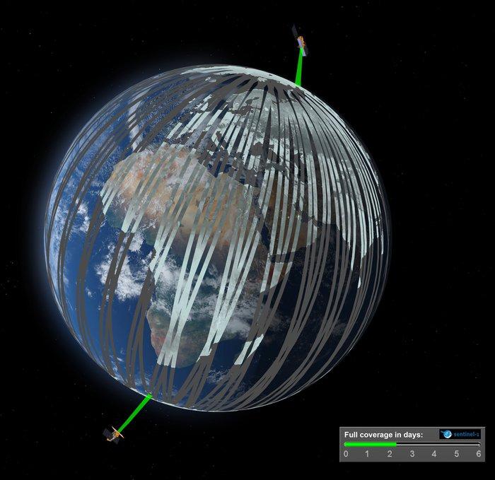
Sentinel 1A/B is the Copernicus Synthetic Aperture Radar (SAR) mission, providing global radar imagery currently at a 12 day repeat period, free from the limitations posed by multispectral imagery such as cloud cover. The launch of Sentinel 1B on the 25th April this year to join in constellation with 1A will reduce this repeat period to 6 days. This will allow for continuous, long term monitoring of the Earth’s Cryosphere at a high temporal resolution.
Sentinel 1 results presented at the conference exemplified the transformative power this mission will have on Cryospheric sciences. Firstly, it will allow us to produce continental velocity maps for both Greenland and Antarctica at sub-annual resolution. This will allow for monitoring of seasonal velocity changes in outlet glaciers, better estimations of mass balance and improved parameterisations of conditions in ice sheet models. Additionally, the mission is now providing researchers with a near real time data stream of ice velocities for key outlets of the Greenland and Antarctic ice sheets, allowing them to track changes and investigate changes in behaviour at 12-day scale (reducing to 6 days with 1B) (Hogg et al, 2016).
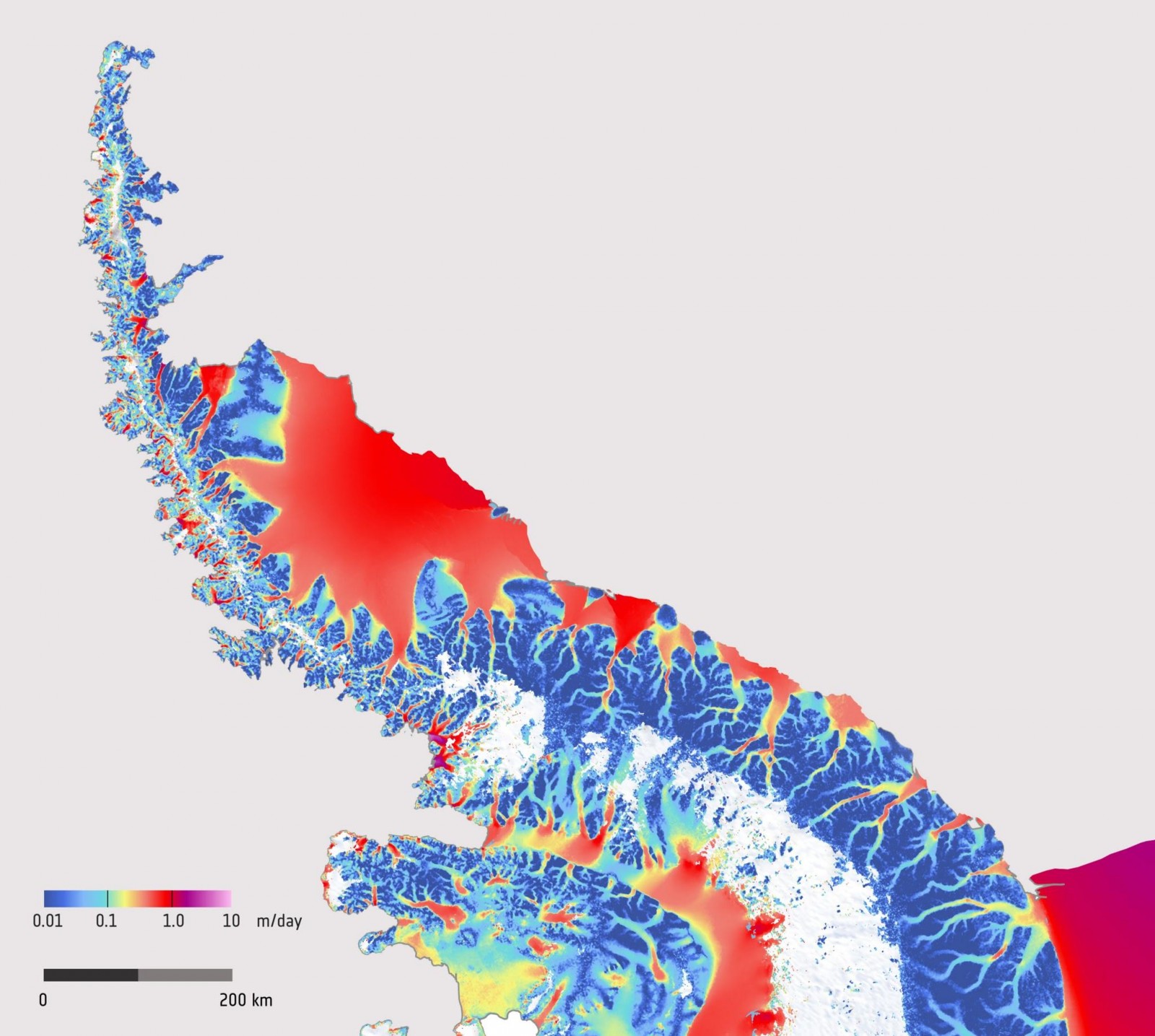
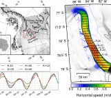
Ice Sheet velocity across the Antarctic peninsula derived from Sentinel 1 data from December 2014 to March 2016. (Credit: ESA and ENVEO)
The grounding line is a key region of the ice sheet to monitor due to it’s ability to indicate changes in the dynamics of the inland Ice Sheet and it’s potential instability. SAR missions allow us to map the grounding line with high accuracy by analysing the differences in vertical tidal displacement of the ice shelves between images via the formation of interferograms. Previously there has been discontinuous temporal coverage from various SAR missions; however with the advent of Sentinel 1 mission, it will possibly to routinely monitor grounding line flux position for an extended period of time, improving our understanding of key ice sheet processes and inland grounded ice stability.
Final Thoughts
The conference showed us the combined power offered by the new Sentinel missions and the continuation of CryoSat-2 in allowing us to monitor the Cryosphere at scales not previously possible, thus shedding more light on the dynamics of these key earth system regions. The new satellites have allowed researchers to produce new and improved datasets open for use by the scientific community, helping to accelerate and enable future discoveries. Additionally, when these datasets are used in combination, they can help us to better answer some of the subject’s biggest questions; such as the mass balance of the Ice Sheets and its changes over time. As a result, these missions promise for exciting times ahead in terms of greatly forwarding our understanding of the Cryosphere.
With the new sentinel missions and the continuation of CryoSat-2 exciting times are ahead for remote sensers of the cryosphere
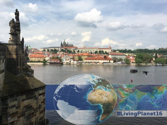
Aside from the Conference – City of Prague
Prague offered many sights and opportunities to explore during the downtime of the conference. Highlights of the City included the Charles Bridge built in 1390 and the old Town Square which hosts the famous astronomical clock. All of this is set to the backdrop of Prague Castle, the largest ancient castle in the world and residence of the President of the Czech Republic. The City also has a famous classical music and opera scene and offers some of the world’s best beer, providing the perfect opportunity to network and make contacts!
References
- Chuter, S. J., and J. L. Bamber (2015), Antarctic ice shelf thickness from CryoSat-2 radar altimetry, Geophys. Res. Lett., 42(24), 10,721–10,729, doi:10.1002/2015GL066515.
- Gray, L, D Burgess, L Copland, R Cullen, N Galin, R Hawley, and V Helm. 2013. “Interferometric Swath Processing of Cryosat Data for Glacial Ice Topography.” The Cryosphere 7 (6). Copernicus GmbH: 1857–67.
- Griggs, J.A., and J.L. Bamber. 2011. “Antarctic Ice-Shelf Thickness from Satellite Radar Altimetry.” Journal of Glaciology 57 (203). International Glaciological Society: 485–98. doi:10.3189/002214311796905659.
- Hogg, A., A. Shepherd, N. Gourmelen (2015) A first look at the performance of Sentinel-1 over the West Antarctic Ice Sheet, FRINGE 2015, Frascati, Italy, 23-27 March 2015.
- Martín-Español, A. et al. (2016), Spatial and temporal Antarctic Ice Sheet mass trends, glacio-isostatic adjustment and surface processes from a joint inversion of satellite altimeter, gravity and GPS data, J. Geophys. Res. Earth Surf., 120, 1–18, doi:10.1002/2015JF003550.
- Tilling, R. L., A. Ridout, A. Shepherd, and D. J. Wingham (2015), Increased Arctic sea ice volume after anomalously low melting in 2013 – supplementary Information, Nat. Geosci., 8(8), 643–646, doi:10.1038/ngeo2489.
Edited by Sophie Berger

Stephen Chuter is a PhD Student at the University of Bristol, UK. He Investigates the dynamics of the Antarctic Ice Shelves and grounding zone using the ESA CryoSat-2 satellite. The unique orbital characteristics and novel SARIn mode of operation allow us to study these areas in much greater detail than possible from previous radar altimetry missions, therefore allowing us to greater ascertain its role in ice sheet stability. He tweets as @StephenChuter.
Contact Email: s.chuter@bristol.ac.uk