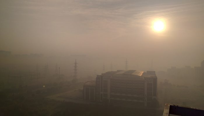
EGU Blogs

5553 search results for "6"

TS
Tectonics and Structural Geology

Minds over Methods: Numerical modelling

Minds over Methods: Numerical modelling

Minds over Methods is the second category of our T&S blog and is created to give you some more insights in the various research methods used in tectonics and structural geology. As a numerical modeller you might wonder sometimes how analogue modellers scale their models to nature, or maybe you would like to know more about how people use the Earth’s magnetic field to study tectonic processes. ...[Read More]

GeoLog

Imaggeo on Mondays: The road to nowhere – natural hazards in the Peloponnese

Imaggeo on Mondays: The road to nowhere – natural hazards in the Peloponnese

The Gulf of Corinth, in southern Greece, separates the Peloponnese peninsula from the continental mainland. The structural geology of the region is complex, largely defined by the subduction of the African Plate below the Eurasian Plate (a little to the south). The Gulf itself is an active extensional marine basin, i.e., one that is pulling open and where sediments accumulate. Sedimentary basins r ...[Read More]

ERE
Energy, Resources and the Environment

The Scorpion and the… Trees: Surface mining (im)practical implications

The Scorpion and the… Trees: Surface mining (im)practical implications

The Scorpion and the Frog. This old tale, which was first documented by the movie Mr. Arkadin by Orson Welles, reports a scorpion that wants to cross a river… and asks a frog for a ride. Embarking on a lose-lose situation, both the frog and the scorpion are doomed in the tale. Dramatic, this fable severely resembles how humans conduct their quest for resource extraction. Surface mining, a pa ...[Read More]

GeoLog

What is in your field rucksack? Camping in Iceland

What is in your field rucksack? Camping in Iceland

Inspired by a post on Lifehacker on what your average geologist carries in their rucksack/backpack, we’ve put together a few blog posts showcasing what a range of our EGU members carry in their bags whilst in the field! Beautiful, eyrie, the land where fire meets ice: Iceland. An Earth scientist’ dream, complete with lava, volcanoes, earthquakes, impossible landscapes, ice, snow, the ocean…Iceland ...[Read More]

CR
Cryospheric Sciences

Image of the Week – Satellite Measurements of Arctic Sea Ice

Image of the Week – Satellite Measurements of Arctic Sea Ice

Sea ice is an important part of the Earth’s climate system. When sea ice forms, it releases heat and salt. When sea ice melts, it takes up heat and adds freshwater to the salty ocean water. It is also important for the exchange of energy between the atmosphere and the ocean surface, and for the ocean currents that transport warm and cold water from the equator to the poles and back. The main route ...[Read More]

CR
Cryospheric Sciences

Water Masses “For Dummies”

Water Masses “For Dummies”

Polar surface water, circumpolar deep water, dense shelf water, North Atlantic deep water, Antarctic bottom water… These names pop in most discussions about the ice-ocean interaction and how this will change in a warming climate, but what do they refer to? In our second “For Dummies” article, we shall give you a brief introduction to the concept of “water mass”, explain how to differentiate water ...[Read More]

GeoLog

GeoPolicy: Science and the policy cycle

GeoPolicy: Science and the policy cycle

One way to improve the impact of your scientific research is to engage with policy. Doing so can create new opportunities for yourself and your research. The main challenges are knowing when and how to effectively communicate scientific results to policy. If the wrong timing or communication method is chosen then results are less likely to be incorporated into the policy process. This month’s GeoP ...[Read More]

GeoLog

Imaggeo on Mondays: what corals can tell us about past climate change

Imaggeo on Mondays: what corals can tell us about past climate change

Reconstructing past climates is a tricky task at the best of times. It requires an ample data set and a good understanding of proxies. Add into the mix some underwater fieldwork and the challenge got a whole lot harder! In today’s Imaggeo on Monday’s post, Isaac Kerlow explains how information locked in corals can tell the story of past climates and how important it is, not only to carry out the r ...[Read More]

WaterUnderground

Brackish groundwater resources: is development advisable?

Brackish groundwater resources: is development advisable?

Authored by: Grant Ferguson – Assistant Professor in the Department of Civil & Geological Engineering at the University Saskatchewan Groundwater makes up a large fraction of the Earth’s freshwater but that represents only a part of groundwater resources. Large volumes of groundwater are saline, with some reaching salinities of over ten times that of seawater. Brackish water is an intriguing pa ...[Read More]

GeoLog

Geosciences Column: A new rock outcrop map and area estimation for the entire Antarctic continent

Geosciences Column: A new rock outcrop map and area estimation for the entire Antarctic continent

Antarctica has been known as “the frozen continent” for almost as long as we have known of its existence. It may be the only place on Earth where, instead of information on the extent of glaciers or ice caps, there exists a dataset of all non-icy areas compiled from satellite imagery. However, this repository is far from perfect: while satellite resolution and coverage have been steadily improving ...[Read More]