EGU Blogs

499 search results for "Imaggeo on Mondays"

GeoLog

Imaggeo on Mondays: Tongue of a small giant

Imaggeo on Mondays: Tongue of a small giant

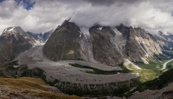
In a world where climate change causes many mountain glaciers to shrink away, bucking the ‘melting’ trend is not easy. In today’s post, Antonello Provenzale, a researcher in Italy, tells us of one glacier in the Alps which is doing just that. Mountain glaciers are retreating worldwide, with the possible exception of the Karakoram area. For most glaciers, ablation (ice melt) durin ...[Read More]

GeoLog

Imaggeo on Mondays: Salt shoreline of the Dead Sea

Imaggeo on Mondays: Salt shoreline of the Dead Sea

This beautiful aerial image (you’d be forgiven for thinking that it was a watercolour) of the Dead Sea was captured by a drone flying in 100m altitude over its eastern coastline. Climate change is seeing temperatures rise in the Middle East, and the increased demand for water in the region (for irrigation) mean the areas on the banks of the lake are suffering a major water shortage. As a result, t ...[Read More]

GeoLog

Imaggeo on Mondays: Breath from the underground

Imaggeo on Mondays: Breath from the underground

The heat seeping from the geothermal area which is part of the Krafla volcanic system in Iceland, ‘powers’ the steaming vent at Hverir (Hverarönd). The area is well known for its mud pots and sulphuric gas fumaroles, complete with pungent eggy smell. Some of the vents are in fact boreholes drilled in the 50’s for sulphur exploration which have been turned into fumaroles, the steam is a resul ...[Read More]

GeoLog

Imaggeo on Mondays: Airplane views of the Alps

Imaggeo on Mondays: Airplane views of the Alps

The forward scattering of sunlight, which is caused by a large number of aerosol particles (moist haze) in Alpine valleys, gives the mountain massifs a rather plastic appearance. The hazy area in the foreground lies above the Koenigsee lake; behind it the Watzmann, Hochkalter, Loferer Steinberge and Wilder Kaiser massifs loom up behind one other to the right of the centre line. Behind them is the ...[Read More]

GeoLog

Imaggeo on Mondays: Erebus Ice Tongue Cave

Imaggeo on Mondays: Erebus Ice Tongue Cave

The interior of this ice cave at the Erebus glacier tongue is cathedral-like. Imagine standing in the cold interior, icy blue stalactites dangling from the cave roof; the sense of awe is overwhelming. Mt. Erbus is the world’s southernmost active volcano on Ross Island, in Antarctica. Winding its way down its lower slopes is Erebus glacier. Projecting out from the coast, a jagged and thin tongue ma ...[Read More]

GeoLog

Imaggeo on Mondays: Natural Bridges Monument, Utah, USA

Imaggeo on Mondays: Natural Bridges Monument, Utah, USA

Slowly but surely, the force of water has carved out a beautiful landscape in the sandstones of the Colorado Plateau. Suspended over canyons, naturally formed bridges and arches are the starts of Utah’s first national monument. The geological and modern  history of the region is rich as Kimberly Galvez, a student of the University of Miami, describes below. This image shows an overview of a ...[Read More]

GeoLog

Imaggeo on Mondays: A lava layer cake

Imaggeo on Mondays: A lava layer cake

Brekkuselslækur, a small river, carves its way across Iceland’s ancient volcanic landscape. At Hengifoss, Iceland’s third-highest waterfall, it tumbles fiercely down thick, dark layers of lavas erupted from volcanoes some 18 to 2.58 million years ago, during a period of geological time known as the Tertiary. Eruptions are rarely continuous; during hiatuses in the extrusion of lavas, ash is able to ...[Read More]

GeoLog

Imaggeo on Mondays: Sedimentary record of catastrophic floods in the Atacama desert

Imaggeo on Mondays: Sedimentary record of catastrophic floods in the Atacama desert

Despite being one of the driest regions on Earth, the Atacama desert is no stranger to catastrophic flood events. Today’s post highlights how the sands, clays and muds left behind once the flood waters recede can hold the key to understanding this natural hazard. During the severe rains that occurred between May 12 and 13, 2017 in the Atacama Region (Northern Chile) the usually dry Copiapó R ...[Read More]

GeoLog

Imaggeo on Mondays: Polar backbone (Arctic Ocean)

Imaggeo on Mondays: Polar backbone (Arctic Ocean)

This image was taken during the Arctic Ocean 2016(AO16) expedition that ventured to the central regions of the Arctic Ocean, including the North Pole. It shows a pressure ridge, or ice ridge, as viewed from onboard the deck of the icebreaker Oden. It was quite striking that the ice ridge resembled an image of a spine – sea ice being a defining characteristic of the broader Arctic environment and b ...[Read More]

GeoLog

Imaggeo on Mondays: Sneaking up from above

Imaggeo on Mondays: Sneaking up from above

Take some ice, mix in some rock, snow and maybe a little mud and the result is a rock glacier. Unlike ice glaciers (the ones we are most familiar with), rock glaciers have very little ice at the surface. Looking at today’s featured image, you’d be forgiven for thinking the Morenas Coloradas rock glacier wasn’t a glacier at all. But appearances can be misleading; as Jan Blöthe (a researcher at the ...[Read More]