Between a Rock and a Hard Place

Science snap

Science snap (7): Thrusting under our noses

As Earth Science researchers, we are extremely fortunate that fieldwork often necessitates trips to exotic and far-flung places. But sometimes we are guilty of ignoring the riches right on our doorstep.

In Bristol (UK), perhaps our greatest geological asset is the Avon Gorge. At the end of the Last Glacial Maximum, torrents of icy meltwater scoured out a 2.5km long gouge through a series of Devonian and Carboniferous limestones and sandstones. The bottom of the 90m deep gorge is now filled with the River Avon and the sheer cliffs of the north side are home to fossil corals, rare plants and challenging climbing routes; they also expose an excellent thrust fault.

This particular example lies at the intersection between Bridge Valley Road and the Portway, just underneath the Clifton Suspension Bridge (see here for map). Compressional forces associated with the formation of the supercontinent Pangea (~290 Ma) caused the the older Clifton Down Limestone to be thrust over the younger Upper Cromhill Sandstone. Friction along the overhanging fault plane deformed the younger sediments, and the resulting instability of the rock face has caused major issues for the adjacent roads.

IMG_0399

Thrust fault in the north side of the Avon Gorge where the older grey Clifton Down Limestone (right) has been thrust over the younger red Upper Cromhall Sandstone (left); the intensity and friction of the thrusting is manifest in the deformation of the younger sediments. The fault outcrops at the intersection between Bridge Valley Road the Portway (A4) and is conveniently located adjacent to set of traffic lights and a cycle path – look out for it next time you’re stuck on a red light or peddling past.

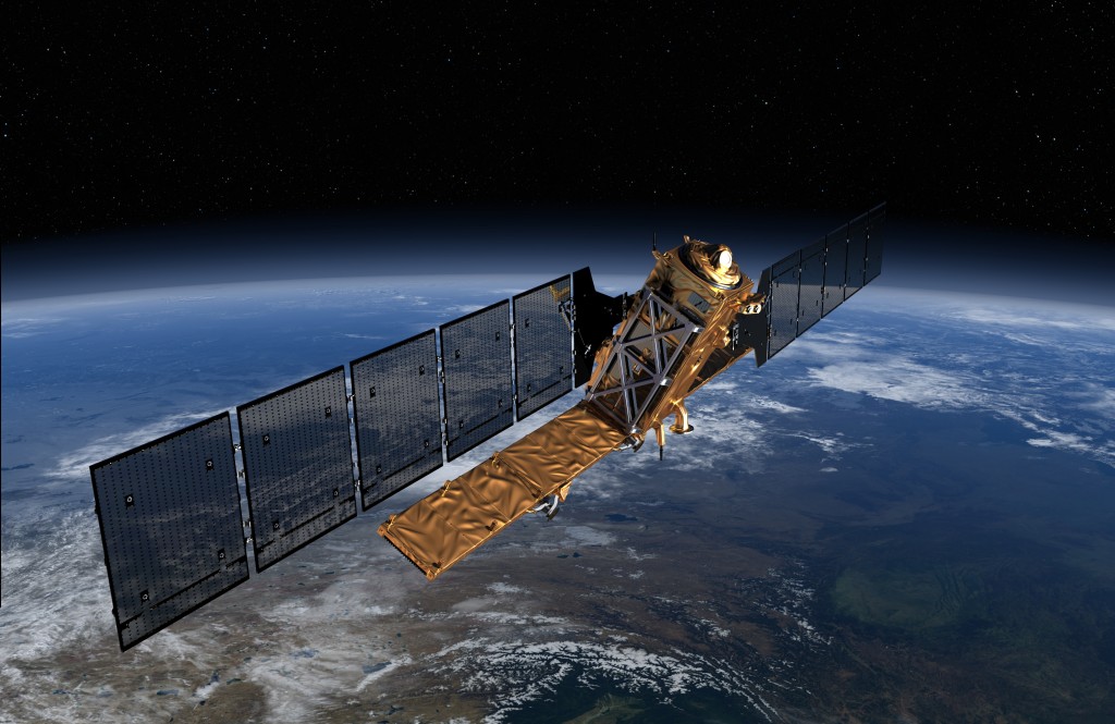
Science Snap (9): Sentinel-1

Sentinel-1 satellite to be launched in Spring 2014. Copyright: ESA/ATG Medialab

Sentinel-1 satellite to be launched in Spring 2014. Copyright: ESA/ATG Medialab


This isn’t strictly a photograph but an artist’s impression of a new satellite launching soon that will hopefully change the pace and advancement of a satellite remote sensing technique I use in my PhD, InSAR. Sentinel-1 will be the first of five European Space Agency (ESA) satellites to be launched as part of Europe’s Global Monitoring for Environment and Security (GMES) ‘Copernicus’ programme. This multi-billion (euro) project “will be engaged in wide range of land and ocean surveillance tasks, such as oil-spill monitoring and earthquake hazard assessment”.

Sentinel-1 will be a polar-orbiting radar satellite that can collect data day-and-night, in any weather condition, and will be ready for launch in spring 2014. The launch of this satellite is exciting for scientists as it will see the continuation of Synthetic Aperture Radar (SAR) data collection that was, until recently, collected by the ENVISAT satellite.

Aside from InSAR, the ESA website highlights other uses of SAR imagery including “monitoring Arctic sea-ice, routine sea-ice mapping, surveillance of the marine environment, including oil-spill monitoring and ship detection for maritime security, monitoring land-surface for motion risks, mapping for forest, water and soil management and mapping to support humanitarian aid and crisis situations”.

Science Snap (6): SEM images of a high-pressure experiment

Sorcha McMahon is a third year PhD student in the School of Earth Sciences at the University of Bristol. Sorcha is investigating how strange igneous rocks called carbonatites may have formed, using both natural samples and high-pressure experiments.

Sorcha's SEM SS

These back-scattered electron (BSE) images are a typical view of one of the high-pressure experiments that I run on the piston-cylinder apparatus, here in the BEEST labs at the University of Bristol. Such photographs are taken using the Scanning Electron Microscope (SEM), and are an essential stage in the analysis of run products as the different shades, textures and compositions are used to identify different mineral and melt phases.

The image on the right shows an entire capsule (a metal container that holds the powdered sample) and its contents after it has experienced conditions of 1375oC and 30 kbar (equivalent to ~100 km depth) for 24 hours. The AuPd capsule (an alloy that can withstand up to ~1400oC before melting at this pressure) appears brighter than the phases produced because this material has a higher atomic mass than the minerals (more information in Charly’s post).

The two images on the left show closer shots of the same experiment, labelled with the different minerals. In varying shades of grey; garnet, olivine, clinopyroxene (cpx) and orthopyroxene (opx) are typical minerals found in lherzolite (‘normal’ mantle) assemblages. As I am working in a synthetic carbonate-bearing system (CMAS-K2O-CO2), my run products contain an abundance of carbonate minerals, such as dolomite. At higher temperatures, melt may be observed, and is identified by its ‘streaky’ quenched texture.

Science Snap (5): Volcan de Colima’s lava dome

12137_684814035389_2533750_n

Credit: Elspeth Robertson

This photograph, taken from a helicopter, is of the lava dome at Volcan de Colima volcano, Mexico in November 2009. Volcan de Colima has been active throughout history with over 40 eruptions since the sixteenth century. The last explosive Plinian eruption was in 1913 blasting out the summit crater. Nowadays, eruptions tend to be effusive with eruptions of lava flows and the gradual build up of the volcanic dome. The dome is formed through extrusion of viscous lava that builds up into the flat-topped dome seen in the photo. Over time, the dome increases in volume and will eventually start to spill over the volcanic edifice creating spectacular incandescent rock falls.

The wispy looking fog you can see surrounding the dome is steam emanating from the dome, which despite its cool exterior, reaches temperatures of 380 degrees Celsius.