EGU Blogs

Simon Redfern

Simon Redfern is a mineral physicist at the University of Cambridge. He studies the properties of materials in Earth, from biominerals in seas shells to the nature of Earth's inner core. He uses neutron and synchrotron light sources to study these properties at the atomic scale, and links the results to phenomena at the global scale. Tweets as @Sim0nRedfern.

Submarine eruptions create huge floating islands

Floating pumice.
Jeff Butterworth

A team of scientists from the UK, the US, Australia and New Zealand have modelled the fate of a huge floating raft of volcanic rocks that formed in 2012 during a submarine eruption of a Pacific volcano.

Described in this month’s edition of Nature Communications, they show how satellite images of the floating-rock raft’s passage across the Pacific can be used to test models of ocean circulation. Their results could be used to forecast the dispersal of future pumice (volcanic rock) islands, and protect shipping from the hazards they pose.

The eruptions of the Icelandic volcano, Eyjafjallajökull, in 2010 brought the hazards associated with volcanic ash sharply into focus. Air routes across northern Europe were disrupted, leaving many passengers stranded and far from home for days on end.

Ocean hazard

But hazards of floating islands of pumice spewed into the ocean from erupting volcanoes are less well-known.

Havre’s pumice raft drifting in the Pacific. The scale bar is 20km.
Nature Communications

One such island grew from an explosion of the Havre volcano in the South Pacific, between Tonga and New Zealand, in July 2012. The volcano threw out a cubic kilometre of molten magma, which suddenly froze to form bubble-filled pumice.

It is the bubbles trapped in pumice that make it so light – half the density of water – so the rock floats on water. Like natural flotsam, pebble to boulder-sized lumps of pumice clump together. This can create huge floating rafts in the seas around erupting volcanoes, and they can be tens of centimetres thick but thousands of kilometres in length.

Records of the use of pumice exist since the time of the Romans and Ancient Greeks. Its rough texture made them effective abrasives to remove dead skin from calluses and corns.

However, today, such floating pumice can pose a hazard for shipping. Hulls can be damaged by abrasion from the hard but light pumice, and when it approaches land these pumice rafts can block harbours and disrupt navigation.

Havre’s pumice island affected an area of ocean twice as big as both islands of New Zealand put together, floating atop the sea. Boats entering the volcanic debris reported engine problems, as the rock and dust clogged their water cooling intakes.

Threat to ocean life

It is not just the effects on shipping that have been a worry. The rafts of pumice stones block the sunlight from reaching plankton in the seas beneath. These plankton form the base of food chain when they convert sunlight to food through photosynthesis, and can be severely affected by floating pumice.

Floating rocks can also act as ferries for exotic invading species, such as shellfish and other organisms that make them their floating home. Indeed, it has been speculated that pumice islands like these were the first home that early life on Earth could have clung to and sprung from.

The study, led by Martin Jutzeler at the National Oceanography Centre in Southampton, UK, shows how the rafts eventually break up into ribbons of rock that can cover a wide area. The simulation techniques that the team has developed will allow the progress of future volcanic rafts to be predicted, and warnings issued to shipping, in the same way as volcanic ash clouds can be forecast for aircraft approaching stratospheric eruptions.

The Conversation

This article was originally published on The Conversation.
Read the original article.

From synchrotron to super-volcano – buoyed up by magma

Thank goodness Mount Sinabung isn’t a supervolcano. Binsar Bakkara/AP

Thank goodness Mount Sinabung isn’t a supervolcano. Binsar Bakkara/AP

Devastating supervolcanoes can erupt simply due to changes that happen in their giant magma chambers as they slowly cool, according to a new study. This finding marks the first time researchers have been able to explain the mechanism behind the eruptions of the largest volcanoes on Earth.

Geologists have identified the roots of a number of ancient and possible future supervolcanoes across the globe. No supervolcano has yet exploded in human history, but the rock record demonstrates how devastating any eruption would be to today’s civilisation. Perhaps most famous is the Yellowstone supervolcano in Wyoming, which has erupted three times in the past two million years (the last eruption occurred 600,000 years ago).

These giant volcanic time bombs seem to explode once every few hundred thousand years, and when they do they throw huge volumes of erupted ash into the sky. At Yellowstone, the eruption that happened two million years ago ejected more than 2000km3 of material – enough to cover Greater London in a mile thick layer of ash.

It is estimated that a super-eruption like that would drive a global temperature drop of 10˚C for more than a decade. Such a dramatic change in global climate is difficult to comprehend. Aside from the instant local devastation, there would be global impacts such as crops failing, followed by large famines.

Despite their potential threat, comparable to a large asteroid impact, the mechanisms and origins of super-eruptions have remained obscure. Modestly sized volcanoes operate on different time-scales and magnitudes, and their eruptions appear to be triggered by pulses of molten rock, magma, which increase the pressure on underground magma chambers that feed their vents.

Two papers recently published in the journal Nature Geoscience try to solve the mystery of how super volcanoes are formed and how they erupt.

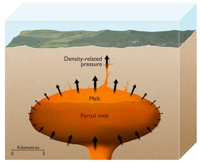
Using experiments and computer modelling scientists have discovered what drives a super-eruption. They find that, over time, the underground magma becomes increasingly more buoyant. It is like a beach ball held down beneath the waves until it is released, when it shoots into the air, forced up by the dense water around it.

In the first paper, a team led by Wim Malfait and Carmen Sanchez-Valle of ETH Zurich the Zurich team used a synchrotron, an instrument that can generate intense X-rays, to measure the density, temperature and pressure of molten rock held in a magma chamber several kilometres below the surface. They mimickeed deep Earth conditions in the lab at the European Synchrotron Radiation Facility, which allows probing of substances held at temperatures up to 1,700˚C and the pressure of 36,000 atmospheres.

An artist’s impression showing the magma chamber of a supervolcano with partially molten magma at the top. The pressure from its buoyancy is sufficient to punch through 10km or more of the Earth’s crust above it. ESRF/Nigel Hawtin

An artist’s impression showing the magma chamber of a supervolcano with partially molten magma at the top. The pressure from its buoyancy is sufficient to punch through 10km or more of the Earth’s crust above it. ESRF/Nigel Hawtin

To feed a supervolcano you need a huge magma chamber. The Zurich team’s results show that as the magma chamber cools it begins to solidify and crystals grow in it that are denser than the magma, which then fall to the base of the chamber. In contrast, the remaining molten rock in the chamber gets progressively less dense, and, if there is enough of it, their measurements showed that the magma eventually becomes light enough that it forces its way through more than 10km of Earth’s overlying crust.

Co-author Carmen Sanchez-Valle, also at ETH Zurich, said: “Our research has shown that the pressure is actually large enough for the Earth’s crust to break. As it rises to the surface, the magma will expand violently, which is a well known origin of a volcanic explosion”.

The second paper by Luca Caricchi and colleagues at the University of Bristol, describes computer simulations of the same processes, finding that the buoyancy of melt in maturing magma chambers is also key to these huge events.

Supervolcanoes require a steady accumulation of molten rock that remains hot enough that it does not completely solidify. It is then simply a matter of time. Malfait’s data show that eventually buoyancy alone is sufficient to trigger these rare, but massive, geological catastrophes.

The eruption of massive supervolcanoes seems to be an inevitable part of their “life cycle”. Just as a star may eventually become a supernova, so a huge magma chamber can eventually become a massive eruption. This contrasts with the way that more familiar smaller volcanoes erupt, where blasts follow directly from rapid injections of magma, or from earthquakes that might trigger them, or even from pressure release on melting of overlying glaciers, as seen in Iceland recently.

This article was originally published at The Conversation.
Read the original article.
Titanic lakes revealed in Cassini’s extraterrestrial bathymetry

NASA/ESA's map of Titan's northern lakes

NASA/ESA’s map of Titan’s northern lakes

The joint NASA-ESA Cassini space probe, exploring Saturn and her moons, has revealed extraordinary lakes and seas of liquid methane around the north pole of Titan. Scientists associated with the Cassini mission described a strange rectangular area of large seas, picked out by imaging instruments aboard the probe. I heard all about it at the recent American Geophysical Union Fall Meeting last month.

Elongated lakes and seas connected by long skinny peninsulas characterise the two seas picked out in the new image. Reminiscent of the topographic depressions in the basin and range province of USA, shaped by the movements of tectonic plates on America’s western fringe, there are suggestions that the large lakes seen on Titan may be tectonically shaped-seas.

“Scientists have been wondering why Titan’s lakes are where they are. These images show us that the bedrock and geology must be creating a particularly inviting environment for lakes,” said Randolph Kirk, a Cassini RADAR team member at the US Geological Survey. “We think it may be something like the formation of the prehistoric lake called Lake Lahontan near Lake Tahoe in Nevada and California, where deformation of the crust created fissures that could be filled up with liquid.”

Scientists described the observations of huge polar lakes called Ligeia and Kraken on Titan, at the meeting of the American Geophysical Union in San Francisco, the world’s largest gathering of Earth scientists.

Alongside the two large liquid bodies picked out so clearly, there is a myriad of smaller lakes that are seen scattered around the pole of Titan. Their origins are unclear, with speculations ranging from volcanic crater lakes to giant sinkholes formed in dissolved Titan crust.

Marco Mastrogiuseppe from Sapienza University, Rome, described the results from RADAR imaging of the fluid bodies at Titan’s surface. “For the first time we were able to observe the topography of the subsurface of an extraterrestrial sea”, he explained.

Cassini’s RADAR has charted the areas of the lakes and seas near the pole, but has also bounced signals off the lake beds in the first depth soundings of an extraterrestrial sea.

“Ligeia Mare turned out to be just the right depth for radar to detect a signal back from the sea floor, which is a signal we didn’t think we’d be able to get,” said Mastrogiuseppe. A maximum depth of around 170 meters, similar to Lake Michigan, was found, and the lake was crystal clear to RADAR eyes.

The total volume of Ligeia is put at 9000 cubic kilometres and it is filled not with water, but with hydrocarbon fluids. The total volume of the hydrocarbon Titanic seas corresponds to around 300 times that of Earth’s oil reserves, in a celestial body smaller than Earth.

The RADAR reflectivity suggests that the lakes are mainly filled with methane alongside a few other heavier hydrocarbon fluids. These include ethane and nitrogen. Alongside Ligiea sits another sea, Kraken. Comparable in size to the Caspian Sea here on Earth, Kraken is four or more times the area of Ligeia. Cassini will return to carry out bathometry of it in August 2014.

Jeffrey Kargel, from the University of Arizona Tucson, pointed out that the presence of extensive methane seas and lakes at Titan’s north pole makes worse a long acknowledged deficiency of heavier hydrocarbons expected from models of Titan’s chemistry. Among them are ethane, ethylene, propylene, acetylene and benzene – heavy hydrocarbons generated as sunlight causes chemical reactions in Titan’s soup of natural gas. Using visual imaging instruments Cassini has revealed that Titan has a northern polar cap larger than Greenland.

Bright deposits around the lakes show the nature of the solid surface. In a world that is difficult to imagine, crystallised heavy hydrocarbons form Titan’s crust, with suggestions of huge dune fields of solid hydrocarbon sand around the equator. While these equatorial “rocks” are saturated in ethane the polar regions appear to be made of methane.

We are now close to summer solstice on Saturn, and Titan has weather that changes with the seasons. Giant storms arise on Saturn, with jets of gas seen shooting from the south pole of cousin moon, Enceladus. A fly-by is planned in 2015 in which Cassini will fly through these plumes and take a closer look at Enceladus’ north pole.

Cassini is now in a set of intricate complicated orbits. Only 4% of its propulsion is left, and future fly-bys are largely powered by the gravitational fields of Saturn and its moons. The probe’s final journey, planned for September 2017 will skirt Saturn’s innermost ring and touch her atmosphere before finally succumbing to the giant planet’s grasp.

This article was originally published at The Conversation.
Read the original article.
Cool and hot eruptions, worlds apart

Rings over Etna. copyright Tom Pfeiffer – volcanodiscovery.com

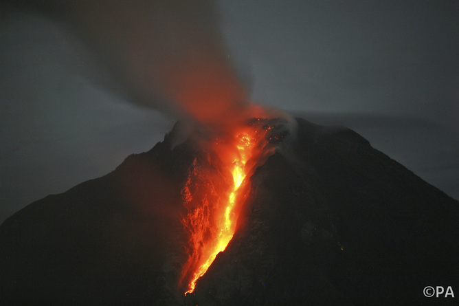
Volcanic Mount Sinbung in Sumatra, Indonesia, has sprung to life in a series of massive eruptions over the last few days. The volcano had lain dormant for more than 400 years before a few minor eruptions three years ago. But this week more than 5,000 people have been evacuated from nearby towns and villages as Sinbung makes her presence felt.

As Sinabung puts on her show of power, in the Mediterranean the volcano Etna has also been active this week. But the view of Etna’s summit is far more gentle, as extraordinary smoke rings have been puffed into the Sicilian sky, as if the volcano is sitting back and relaxing for a while. Photographer Tom Pfeiffer managed to capture the scene with a series of fantastic shots.

Puffing away. copyright Tom Pfeiffer

Steam rising. copyright Tom Pfeiffer

The Indonesian volcano, however, erupted an ash cloud more than four miles into the air. A super-heated avalanche of lava, ash and rock raced down its flanks at terrifying speeds on Monday. There are reports of a stream of red hot lava extending a kilometre or so from the vent.

Sinabung’s activity is fed by the slow tectonic descent of rocks forming the floor of the Indian ocean, drawn down and northward into Earth’s mantle beneath Indonesia. This geological feature is called the “Sunda Arc” and it is home to some of the largest volcanic eruptions ever seen.

While Sineburg rages, Etna chills; copyright Tom Pfeiffer

The 1815 eruption of Mount Tambara, above the Sunda Arc, remains the largest recorded volcano ever. But it is topped by the super-eruption of Toba, also in Sumatra, which scientists place at 70,000 years ago as the largest in human history. The eruption of Indonesian Krakatoa was smaller than both, yet was heard 3,000 miles away and caused widespread devastation and more than 35,000 deaths.

Indonesia, the world’s fourth most populous nation, sits atop a geological powder keg. This week’s eruption of Sinabung serves as a reminder.

The Conversation

This article was originally published at The Conversation.
Read the original article.