EGU Blogs

interdisciplinary

Rocks in the right place at the right time…

Rocks in the right place at the right time…

Flo looks two examples of the strange and important ways that geology and where it’s located can affect international governance and regulation. From the presence of tiny coralline islands to ownership of the Arctic!

I’ve always had an interest in the peculiarities of geology and geomorphology and the inordinate (sometimes almost absurd!) ways that they play their part in deciding on big international governance. Humanity has long-relied on the presence of geological features such as mountain ranges, coasts, rivers etc. to delineate ownership and basis on which to set ‘ground rules’.These geological features account for many historic and modern day national borders and so the odd rock in the right place at the right time can be very handy (or not, depending on which side of the coin you’re on…).  Sometimes this works well, countries such as India and Chile use enormous, previously impassable mountain ranges such as the Himalayas and the Andes as their natural borders and this has worked relatively well. Island states such as the UK assume their land borders at the point where land meets the sea, which also works for now but is ultimately just a function of current sea level. But in a dynamic world, the formation and loss of landmass and particularly changing sea levels will be shifting quite considerably in the face of human-induced climate change, and so the previously established rules and regulations about ownership and governance may start to become and bit less solid than it was…so where does this leave us?

I’m going to look at a couple examples of where geological features have influenced the distribution of governance responsibility among nations, and just how flimsy that burden of proof can get!

The Arctic
2007_Arctic_Sea_Ice - Copy (2)

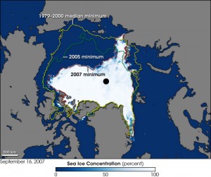
The image shows a record sea ice minimum in the Arctic, taken in September 2007. Image Credit – NASA, Wikimedia Commons.

One great example of how small, uncontrollable things can influence major decisions and changes, is the right to ownership and governance of the Arctic. The ongoing in reduction of sea ice in the Arctic due to climate change and recent developments in technology that would allow development of Arctic resources has led to something of an arms race with countries laying claim to large tracts of the region. The scientific basis for many of these claims is based on the mapping of ocean ridges and where they sit in relation to the Arctic states (Canada, US, Russia, Denmark, Finland, Iceland, Norway and Sweden).

The process for assigning areas of the Arctic is both scientific and political but nation states must prove through surveying that there is continuity and that they are geologically ‘attached’ to the Arctic by a ridge. The most recently lodged claim is that of Denmark, who, via Greenland a semi-autonomous Danish territory (another potentially fortuitous link in this chain), can lay claim to an area of 895,000 square kilometers due to the extension of the
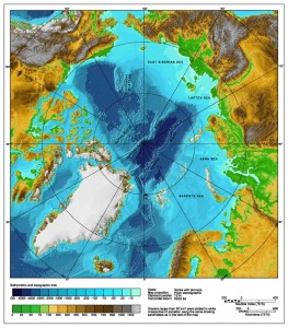
Bathymetric map of the Arctic Ocean. Image Credit - NOAA, Wikimedia Commons.

Bathymetric map of the Arctic Ocean. Image Credit – NOAA, Wikimedia Commons.

Lomonosov ridge, according to a senior geophysicist with the Geological Survey of Denmark and Greenland. Denmark has filed a claim to the area to the UN linked to the ridge, and if successful will have access to a sizable chunk of the Arctic’s resources. The regulation that covers these kind of claims is the U.N. Convention on the Law of the Sea which states that nations are entitled to a distance of 200 nautical miles from their coast, any claims beyond this reach need to be supported by scientific data. This most recent claim is the fifth from Denmark who have also previously submitted claims north of the Faroe Islands (another Danish territory) and in an area south of the Faroe Islands. This builds on a body of work where Danish scientists surveyed a 2000 kilometer long underwater mountain range that runs north of Siberia, they concluded that this ridge is geologically attached to Greenland. All of the submissions await consideration by the Commission on the Limits of the Continental Shelf , the Danish statement currently overlaps with with Norway’s continental shelf beyond 200

A USSR postcard depicting Soviet dominance of the Arctic! Image Credit - kristofer.b, Wikimedia Commons.

A USSR postcard depicting Soviet dominance of the Arctic! Image Credit – kristofer.b, Wikimedia Commons.

nautical miles and there are also potential overlaps with claims by Canada, Russia and the U.S.

Some people involved in the process had hoped that control of the Arctic would be decided on through a ‘Gentleman’s agreement’ rather than the tough negotiations that will now ensue.

The United Nations panel will eventually decide control of the area, and the sea floor boundaries will be settled by international negotiations but this process won’t begin until the  scientific data has been examined. This is expected to take 10-15 years, by which stage the politics around accessible resources in the Arctic will have intensifed due to increased global warming creating easier access to many of the oil and mineral reserves, so this topic isn’t going away!

Okinotori Islands

This tiny uninhabited set of islands, 1100 miles south of Tokyo in the Phillippine Sea is currently also responsible for lending control of a 160,000-square-mile economic zone in the surrounding waters. The most southerly of Japan’s landmass is only 7 miles around and it is just, and only just, keeping its head above water. Herein lies the problem, according the the UN’s ‘Law of the Sea’ ( useful but problematic bit of regulation), any claim to an exclusive economic zone, (such as Okinotorishima, or ‘distant bird island’) like the one in Japan is
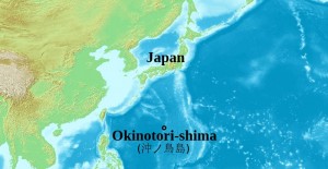
Location of the Okinotorishima islands in the Phillippine Sea. Image Credit - ForestFarmer, Wikimedia Commons.

Location of the Okinotorishima islands in the Phillippine Sea. Image Credit – ForestFarmer, Wikimedia Commons.

dependent on the existence of a habitable island landmass existing in the area. If this island sinks beneath the water then the whole claim to the economic zone sinks with it, along with important mineral and fish resources for Japan. The claim, even if the islands stay above water isn’t uncontested, China disputes the ownership stating that  the islands are just a cluster of uninhabitable rocks and doesn’t fulfill the requirement of ‘habitable’ at all! While it’s true that no one lives there, the small area is host to a small man-made islet with a platform which is used as a weather monitoring station with a building that houses researchers.

The usefulness (and contention) of these islands and their slow sinking has not bypassed the Japanese government who have set up programs (and considerable investment) to keep the islands bobbing above sea level. The project to keep the island above water is two-fold, the Japanese government have installed protection around the island in the form of  cement, steel blocks and titanium mesh to protect from erosion and the increasing number of tropical storms.
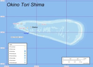
800px-Okinotorishima2

Map of Okino-Torishima, Pacific Ocean. Image credit – Ratzer, Wikimedia Commons.

However the ‘sinking’ is not just due to erosion and damage but also due to the low production of coral.  This is thought to be due to the warmer waters in the area lowering coral growth.  This loss of landmass and the important politics associated with it has meant that several agencies have made it a priority to revitalise the growth of  corals, although it’s not quite that simple! This involves applying a method of sexual reproduction developed over the past 20 years to cultivate corals. According to the fisheries agency, about $19 million ( of tax payers money…) has been spent to breed about 100,000 coral plants using the method with a success rate of approximately 20%. It remains to be seen whether this rock, doctored or otherwise, will be in the right place for the Japanese authorities in years to come…..

It’s worth reflecting that with both these examples, not only are they wholly reliant on the location of bits of geology to define long-lasting rules, regulations and potentially economic opportinities that can make or break countries but also these rocks (in a geological sense) are totally transient, and the ridges that secure the Arctic and the corals that secure the economic zone for Japan just happened to be in the right place at the right time. Throw in an exntending ridge of a destructive plate margin somewhere else and this fragile hierarchy would be thrown into disarray.

Further Reading

BBC News – Denmark challenges Russia and Canada over North Pole.

Phys.Org – Denmark claims North Pole link via Greenland ridge link

NPR.org – Denmark Claims Part Of The Arctic, Including The North Pole

Global News – Denmark claims North Pole through Arctic underwater ridge link from Greenland

New York Times –Growing Coral to Keep a Sea Claim Above Water

You Tube – China refutes Japanese claim about Okinotori Reef as island

Asia-Pacific Journal – Japan Focus – The US-Japan-China Mistrust Spiral and Okinotorishima


What’s geology got to do with it? 4 – Tennis!

What’s geology got to do with it? 4 – Tennis!

 As part of the ‘What’s geology got to do with it?’ series, Flo takes us on a tour of the links between geology and tennis! Warning: You may not want to read this if you have no interest in Geology OR tennis…. 

Now the disclaimer’s out of the way, I thought it was about time I married two of my greatest loves in life, Geology and Tennis. These two interests may seem completely at odds in terms of relevance, but as is the beauty with geology, it relates to just about everything!

So, summer in the northern hemisphere and therefore the two biggest Grand Slams in tennis are upon us!  The French Open, the king of the clay-court season is currently underway and Wimbledon, the jewel (and one of the few remaning…) grass court tennis tournaments is just around the corner.

But for a sport containing so few tangible objects: a court, a racket, a person and a tennis ball, how does it relate to Geology? Well….

Tennis Courts

491px-ND_DN_2006FO

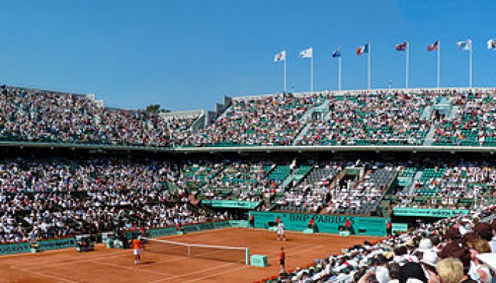
Court Philippe Chatrier Court at the French Open, the only Grand Slam played on red clay. Source – Wikimedia Commons

Professional tennis is  played on 3 types of court surface, each with its own season during the tennis calendar.  You have the hard court season, which dominates most of the year between July and February, beloved by Djokovic, then you have the European and North and South American clay court season from February to May, favourite of clay-court extroadinaire Rafa Nadal and then the shortest season of all, the grass court season, occupying all of 4 weeks in the summer, from June-July, once dominated by Federer and recently by Murray! The most obvious link to geology here is the clay courts, so how do you go about building a clay court and what materials do you need?

Red Clay Courts

Well first of all, very few clay courts are actually made of natural clay. This is because they can take a very long time to dry out (which you’ll know if you’ve ever done any pottery….). For this reason, the red clay courts as seen at the French Open and numerous other clay court tournaments are actually made from crushed brick or shale. Bricks are used because they absorb water less easily than natural clay and are produced from a mix made from Alumina (clay), sand, lime and iron oxide before being fired until dry.


guga-kuerten-trophy-frenchopen08

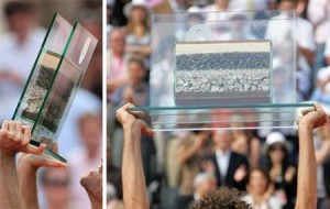
Guga Kuerten being awarded a cross-section of the court in his last match at the French Open in 2008. Source – Tennis Served Fresh Blog

So if you want to build a clay court like the famous red-clay courts of the French Open, first of all you need to lay a base layer, this is covered with a layer of crushed stones, this is then overlain by a layer of clinker. This is then followed by a layer of crushed limestone and finally, the crushed brick forms the thinnest layer at the top. A cross section of the layering under the court surface formed the trophy that former French Open champion Guga Kuerten received when he played his last match at the tournament in 2008!

800px-Drying_mud_with_120_degree_cracks,_Sicily

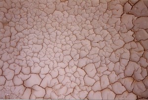
You wouldn’t want the Philippe Chatrier court looking like this after a few hours of sunshine! Source – Wikimedia Commons.

Maintenance of the court after completion is a bit tricky as the clay needs to be constantly smoothed and watered in order to prevent dewatering cracks, a feature that many geologists are very familiar with!

Green Clay Courts
800px-Maria_Sharapova,_2008_Family_Circle_Cup

Maria Sharapova playing on the ‘green clay’ at the Family Circle Cup. Source – Wikimedia Commons

Not all tournaments use red clay, so called ‘green’ clay’ or ‘Har-Tru’ has become very popular in the United States. Har-Tru courts are similar in construction but are made from crushed basalt rather than brick meaning they are slightly harder and faster. According to their website, Har-Tru courts are made from ‘billion-year old Pre-Cambrian metabasalt found in the Blue Ridge Mountains of Virginia‘. This rock has two important properties, which is that it is hard and angular which allows it to ‘lock together to form a stable playing surface’ and the hardness provides ‘exceptional durability’.

Tennis rackets

800px-Tennis_Racket_and_Balls

A modern tennis racket with a carbon fiber-reinforced polymer frame. Source – Wikipedia Commons

As with many manufactured items, the raw materials required to make them eventually leads us back to our natural resources in the ground. Earlier tennis rackets were always made from wood, with strings made from gut, but these days, advancements in materials technology means that the majority of professional frames are made from ‘high modulus graphite and/or carbon fibre while titanium and tungsten are often added to give the frame more stiffness and the strings are made from nylon (although Federer and Sampras are famous for using natural gut strings).

Supplies of pure titanium are rare although titanium ores such as ilmenite and rutile are much more common. Titanium is largely mined in the titanium-rich sands of Florida and Virginia as well as Russia, Japan, Kazakhstan and other nations. Much more rare is Tungsten, which has seen a rapid rise in price in recent years as supplies dwindle. Tungsten has recently emerged as a ‘critical’ metal with the majority of the world’s tungsten supply located in China. However Hemerdon mine  in Devon which has been closed since 1944, is thought to host one of the largest tungsten and tin deposits in the world, and is set to reopen under control of an Australian firm in the near future with permit plans progressing this year.

For more on how a tennis racket is made: http://www.madehow.com/Volume-3/Tennis-Racket.html

Tennis Balls

427px-Tennis_balls,_advertisement,_19th_century

Tennis ball advertisment, 19th century. Source – Wikimedia Commons

According to an article in the guardian published in 2013, manufacture of Slazenger tennis balls now has a 50,000 mile production journey before they end up in Centre Court at Wimbledon. Part of this journey includes the transport of various mineral resources. These include the transport of clay from the United States,  Petroleum Napthalene (derived from coal tar) from China, Sulphur from South Korea, Magnesium Carbonate from Japan, Silica from Greece and Zinc Oxide from Thailand. This exemplifies not just the truly global nature of the manufacturing markets but also the complex importing and exporting of many natural resources for something as simple as a tennis ball.

For more on how tennis balls are made, see the ITF website: http://www.itftennis.com/technical/balls/other/manufacture.aspx


Tennis Net

courtmaster-net

Anatomy of a tennis net. Source – Do it tennis website.

The majority of the different parts of a tennis net are made up from either polyester or polyethylene, both formed synthetically. However, the raw materials required to synthesise both materials  started off as extracted hydrocarbons. Polyester synthesis requires the polymerisation of ethylene which is derived from petroleum.

60 million tonnes of polyethylene is manufactured each year and is the world’s most important plastic. It is made by several methods by addition polymerisation of ethene, which is principally produced by the cracking of ethane and propane, naptha and gas oil, all hydrocarbon fractions. In Brazil, a plant is being constructed to make polyethylene from sugar cane via bioethanol.


And that’s how geology underpins everything we know and love about tennis!


For more information on the link between sports and geology, see the United States Geological Survey’s article on ‘Minerals in Sports: Tennis’: http://minerals.usgs.gov/minerals/pubs/general_interest/sport_mins/tennis.pdf

Policy Focus: 1 – Creating value from Waste

Waste and recycling is a growing issue in a world where abundant resources are diminishing. This week Flo Bullough looks at recent policy activity in the area of ‘valuing waste streams’ and the geo-relevant example of Rare Earth Elements.

This week, the House of Lords Science and Technology committee has been taking oral evidence on the topic of ‘Generating value from waste’ with a particular focus on the technology and processes used to

House of Lords Chamber. Source - Wikimedia Commons

House of Lords Chamber. Source – Wikimedia Commons

salvage raw materials from waste and what the government can do to encourage and assist progress in this area.

This topic was also discussed in a recent European Commission consultation on the Review of European Waste Management Targets and the Raw Material initiative which highlights the importance of recycling to ensure safe access to raw materials. Consultations like these seek to engage with experts in the relevant field and are useful research and fact-finding exercises to inform future government policy.

This is all part of a wider plan to try and incorporate the disposal and cost of waste into the manufacturing life cycle. Additionally, waste is not just a cost burden but can also be a source of valuable materials that can be recycled.  In 2009 Friends of the Earth published a report entitled Gone to Waste – The valuable resources that European countries bury and burn. This included data on the value of the waste we don’t recycle and the associated CO2 emissions. The report also attempted to calculate the monetary value of recyclables. They found that in the UK in 2004, the value of materials classified as ‘key recyclables’ that had been disposed of as waste,  was a minimum of £651 million (based on values for materials such as glass, paper, iron, steel and biowaste. Rare earth elements were not included in their study).

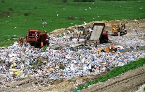
800px-Wysypisko

Landfill Site. Source – Wikimedia Commons.

Geo-Relevant Example – Rare Earth Elements

220px-IPhone_Internals

Internal view of an iPhone. Rare earth elements are used in the manufacture of electronics such as smart phones but when replaced often end up in landfill. Source – Wikimedia Commons

The concept of valuable waste is particularly true of the rare earth elements that end up in waste streams through discarded electronics. Demand for rare earth elements is soaring while scarcity and market cost is increasing. Rare earth elements are essential to many commonplace electronics such as mobile phones and computers as well as in renewable technology such as wind power. The supply of these materials is finite and the market is currently dominated by China (see this excellent post from Geology for Global Development on the issue) which has its own geopolitical implications and so increasing focus from both an environmental and economic perspective is to extract these valuable materials from waste streams.

In terms of current research into Rare Earth Element recycling, Japan is the only place where significant research is being undertaken. An example of this is Hitachi who are aiming to be able to recycle electric motor magnets. It was also announced last year that the US is to build a $120 million ‘Critical Materials’ institute in Iowa which will focus, amongst other things on developing recycling techniques.

For more information see the following links:

Chemistry World – Recycling rare earth elements using ionic liquids

Mining.com – Rare earths recycling on the rise

POST note from the Parliamentary Office of Science and Technology – Rare Earth Elements


Raising the Dead Sea

Raising the Dead Sea


The Dead Sea is one of the planet’s truly otherworldly places: a peculiarity of water distribution, climate and altitude, it is even more extroadinary in that it is a site of religious, cultural and political significance. Viewed by many as a natural wonder, its characteristics and location within one of the most entrenched political situations in modern history makes it intriguing and troubled in equal measure.

The Dead Sea is the deepest hypersaline lake in the world, situated at the lowest point on earth. It has a salinity of 33.7% due to high concentrations of NaCl and other mineral salts.  The Dead Sea, aside from being a misnomer (it is actually an inland lake) is so-called because of the harsh living conditions that the salinity engenders. Many organisms such as fish cannot live there, in fact only populations of bacteria and microbial fungi can thrive.

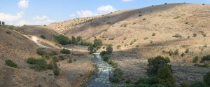
800px-Yarden_034PAN2

The Jordan River. Source

Located in the Jordan rift valley bordering Jordan to the east, and Israel and Palestine to the west, it is served only by the Jordan River to the North. A combination of the mineral content of the water, low content of pollens, the reduced ultraviolet component of solar radiation and the higher atmospheric pressure at this depth have specific health effects which have borne a booming spa-tourism economy. This along with the dramatic scenery and tranquil waters is why it has long been a site of tourism and refuge; King David used it as such and it was one of the world’s first health resorts for Herod the Great.

There are two schools of thought as to how it formed; one is that the depression forms part of the East African rift valley complex and, another more recent hypothesis describes the formation as a ‘step over’ discontinuity along the Dead Sea Transform creating an extension of the crust. The sea was once connected to the Mediterranean and experienced regular flooding, resulting in thick layers of salt deposition. The land between the Mediterranean and the Dead Sea subsequently rose to cut the basin off and create a lake.

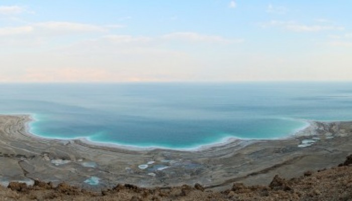
What’s the status now? 

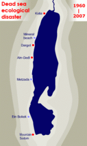
The dwindling water level of the Dead Sea. Source

The dwindling water level of the Dead Sea. Source

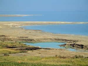
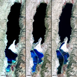
The Dead Sea in more recent years has been characterised by a decline in water levels, a drop of ~30m since 1960 alone and is currently shrinking by around 1m/year. This is in part due to a drop in rainfall and the use of water upstream of the Jordan river for irrigation projects. Declining water levels have resulted in a wide variety of environmental issues for the Dead Sea ecosystems and surrounding region. One such issue is the ever-feared rumble that precedes the formation of sinkholes; these can be unpredictable and can occur suddenly almost anywhere in the Dead Sea region. Indeed, the level of uncertainty and rapidity of sinkhole formation is such that around 10 years ago, renowned geographer-geologist and expert on sinkhole phenomena Eli Raz was swallowed up by one and waited 14 hours for rescue!

Sinkholes in the Dead Sea area are caused by the interaction of incoming freshwater with subterranean salt layers.  As the sea level drops, high levels of salt are left behind in the soil and when freshwater washes in from the Jordan River it dissolves the salts and cavities are created. This process continues until the subterranean structure loses integrity and sinkholes are formed.  It is estimated there are now about 3000 in the region of the dead sea with an opening up of around 1 a day.


800px-Dead_Sea_sinkhole_by_David_Shankbone

Sinkholes along the shore of the Dead Sea. Source.

Why is the water level dropping?

Jordan, Syria, Palestine and Lebanon have all tapped the Jordan river for water over the last few decades for irrigation purposes resulting in a reduced flow into the Dead Sea.  An area with historically low rainfall, ~ 2 inches a year, enormous amounts of water is also piped off to fill evaporation pools for the potash and magnesium industries which sit at the very southern end of the sea. This alone is thought to result in a 30-40% reduction in water.

In the last 50 years, the population in the surrounding countries of Israel, Palestine and Jordan has increased from 5.3 million to over 20 million with an increase in the settled population in the Dead Sea region. Currently, tens of thousands of tourists visit every year to bathe in the sea and use the many resorts and spas found along the shores and visit the mighty ruin of Masada (including me!) that overlooks the Dead Sea. Tourism is growing in this area and makes up about 40 percent of the income of local residents and this is putting further pressure on diminishing water resources.

The_Dead_Sea_1972-2011_-_NASA_Earth_Observatory

Views of the Dead Sea in 1972, 1989, and 2011 compared. Source.


How can environmental catastrophe be avoided?

The delicate balance of inflows, outflows, evaporation and rainfall has been severely disturbed in the last 50 years, and this hasn’t gone unnoticed. A highly ambitious project is underway to replenish the Dead Sea and ameliorate some of the water and energy shortage issues in the region. The World Bank, together with the local governments is planning to create a canal linking the Red Sea to the Dead sea.  The project includes a series of studies including feasibility, environmental and social assessment with the aim of generating a trilateral agreement between Palestine, Jordan and Israel. If the plan goes ahead as detailed, the pipeline will deliver 2 billion cubic metres of sea water per year from the Gulf of Aqaba through Jordanian territory and to the Dead Sea. The plan is to also use the downwards flow between the Red Sea and the Dead sea to incorporate a hydroelectric plant. This is in turn will power a desalination plant which would provide up to 850 million m3 of fresh water per year to a water parched region. The briny discharge from the desalination plant would then be discharged into an already-saline Dead Sea. The project is likely to cost at least US $10 billion, a significant proportion of this is taken up by the cost to pump the desalinated water 200km over an altitude change of 1000m from the Dead sea towards Amman, an extremely parched area.

782px-ArabianSea_AMO_2005053_crop

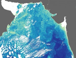
Algal Blooms in the Arabian Sea. Source.

So, it sounds good but is it really that simple? Many studies find that if more than 400 million m3 of sea water is added to the Dead Sea, this could result in the formation of algal bloom and unsightly gypsum crystals, the effects of which have effects that are difficult to predict, this will impact on the image and chemistry of the Dead Sea. Although the ecological effects of these chemical changes are still unclear, they would likely diminish the sea’s tourist appeal. This is in addition to the fact that the amount of water supplied would not be enough to stabilise or increase the level of the Dead Sea. There is also concern about the effects of mixing Red Sea water with Dead Sea water. Many other alternatives have been mooted by environmental groups, such as water recycling and conservation by Israel and Jordan, importing water from Turkey and desalinating sea water on the Mediterranean coast. Whilst pumping desalinated sea water from the Mediterranean to Ammam would be easier and cheaper, the geopolitics are concerning. Many worry that Israel would control the supply to Ammam.  Another very real concern is the high frequency of earthquakes in the region, seismic activity could cause salt water to leak into underground fresh water aquifers. Others would prefer to see the rehabilitation of the Jordan River with a greater utilisation of desalination to provide water to the Mediterranean coast.  All of these alternatives however require cooperation and a regional approach to water sharing which is difficult in this part of the world to say the least.

Regional Water Security

This issue sits within a wider problem. This is a region with extremely low levels of rainfall and a booming population. Jordan are well behind the Red-Sea-Dead-Sea project largely because the country’s access to fresh water is extremely restricted, which has been exacerbated by the arrival of more than a quarter of a million Syrian refugees since the outbreak of the civil war.

800px-Nitzana_desalination_(2)

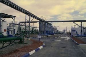
Nitzana desalination plant in Israel. Source.

Israel has long had issues with water scarcity. Due to low rainfall and a booming industry, the demand on water outstrips conventional water resources. This is put under further strain from the water-intensive agricultural practices used throughout the country.This is in part alleviated by their technologically advanced desalination plants dotted along the Mediterranean coast.

Gaza, on the Mediterranean coast is thought to be heading for a serious water crisis in the coming decade with 90-95% of the main aquifer contaminated, the UN suggest the water might be unusable by 2016. Meanwhile water shortages in the West Bank affect the provision of drinking water, water used for farming and agriculture in addition to that required for basic sanitation.

Regional Geopolitics

The regional geopolitics is intensely complex with many historic and current political factors at play. Others can write much more authoritatively on the area but it is worth mentioning here because, as with many geological issues, the interplay between the two is important.

The main regional players are Israel, Palestine and Jordan. Jordan, with few freshwater resources and no oil to power desalination plants, has long been considering an engineered solution to alleviate the water issue in Jordan. At peace with Israel since the signing of a treaty in 1994, the Jordanian government is hoping the plan goes ahead in full.

Israel and Palestine are significantly more complicated. The current de facto borders of Israel and Palestine are broadly along the lines drawn following the ‘Six Day War’ in 1967, as seen in the image, where Israel extended its borders and captured, among other territories, the West Bank.

West_Bank_&_Gaza_Map_2007_(Settlements)

Map of the West Bank and Gaza Strip. Source.

Contemporary Palestine now exists as two non-coterminous territories: the Gaza strip, which is on the Mediterranean coast (run by Hamas) and whose borders are controlled by Israel and Egypt, and the West Bank (the name of which refers to the Jordan River) which borders Israel to the north, south and west, and Jordan to the east. Civil and military authority in the West Bank is a mixture of the Fatah-led Palestinian Authority and the Israeli state. The Dead Sea spans the south east corner of the West Bank, as well as parts of Israel and Jordan. Whilst the West Bank shares a geographical border with Jordan, this is controlled by Israel, and the West Bank remains under Israeli occupation under international law.

In a region with scarce water resources, distribution can be controversial – and Israel’s monopoly over a shared aquifer and access to the Jordan River has resulted in the state being accused of restricting access to water for Palestinians.

Palestine (despite divisions in governance across the two territories) is still seeking independent statehood, and in 2012 was recognised at the United Nations as a ‘Non-member observer state’. As such, negotiations over multilateral initiatives such as the Red Sea-Dead Sea project have enormous geopolitical implications. 

Other Cross-boundary Water Conflicts

There are many examples of delicate border regions which cut across natural river systems, such is the nature of modern national borders, they very rarely follow catchment areas and as such control over and use of water bodies can be highly contested.

Cross boundary water engineering negotiation goes on in many areas around the world and these often intersect with political and environmental issues. In addition to the Dead sea and Jordan river the Nile is subject to boundary issues, running through Egypt, Sudan and Ethiopia. Egypt and Ethiopia are currently negotiating over a billion dollar dam project being built in Ethiopia. Egypt are looking to help with the construction of the dam project.

The Caspian Sea has also had more than its fare share of water-rights disputes. A massive sea in Central Asia, its issues descend from the break up of the Soviet Union in 1991 and thus increasing the number of countries with an interest. As such a number of plans have been proposed and rejected due to lack of unanimity leaving the legality and governance of the area up in the air and resulting in resource grabs and export of resources struck without agency.

As with the Dead Sea, these examples show the great complexity in dealing with cross-boundary water management and no situation is the same, and must be dealt with carefully and on a case by case basis.

Flo

Further Reading

BBC News – Project to replenish Dead Sea water levels confirmed

Phys Org – Dead Sea, Red Sea plan raises environmental hackles

Nature – Environmental concerns reach fever pitch over plan to link Red Sea to Dead Sea

Slate – The Dead Sea is Dying