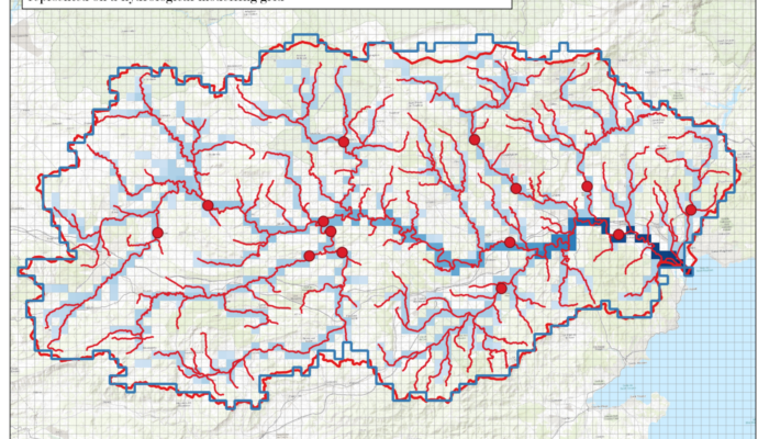
Do you know how scientists predict and analyse river flows using computer models? In this blog, Juliette Godet explores the tricky task of matching real-world river measurement points to grid cells in these models. Picture a giant digital map of a river basin, divided into grid squares, and a real-life gauge that measures river flow at a specific point. The job is to figure out which grid cell bes ...[Read More]
Higher Education Resource: Sandbox Modelling for Basin Development
The European Geosciences Union (EGU) supports bringing science into the classroom at all learning levels, from schools to universities. Since the Higher Education Teaching grant programme launched in 2020, EGU has funded 24 projects to develop useful and freely available geoscience resources to university educators. This blog is part of a series of blogs highlighting the innovative and accessible ...[Read More]
Higher Education Resource: River Flood Hazard Modelling & Management
The European Geosciences Union (EGU) supports bringing science into the classroom at all learning levels, from schools to universities. Since the Higher Education Teaching Grant programme launched in 2020, EGU has funded 24 projects to develop useful and freely-available geoscience resources to university educators. This blog is part of a series of blogs highlighting the innovative and accessible ...[Read More]
Turning adversity into opportunity: mapping plastic pollution in rivers
In July 2021, the Benelux area, Germany, and France experienced heavy rainfall followed by mass flooding, causing widespread damage. Along the vast quantities of plastic swept along the riverbanks, Rahel Hauk, a researcher from Wageningen University, conducted fieldwork to assess the impact of the flood event on plastic deposition. Amidst the debris, Hauk and her colleagues noticed a large volume ...[Read More]