On August 4, 2020, the coast of Beirut, the capital of Lebanon, was rocked by an explosion caused by the blowing up of 2750 metric tons of ammonium nitrate, a chemical used in fertilizers (Figure 1). It resulted in at least 181 casualties, 6,000 injuries and 10-15 billion US dollars in damage [Ref 2].

USGS Community Internet Intensity map showing the intensity of the damage caused by the explosion based on the online community reporting and metadata including time, depth and the epicentre of the explosion. Source: USGS [Ref 4]
The explosion’s shock waves created a 140 m wide crater, levelled nearly all buildings in the direct surroundings, and caused extensive damage throughout the entire city and even far offshore [Ref 2]. The shaking was felt as far as Cyprus, 240 km away, where testimonies submitted to the LastQuake app reported windows and walls rattling and shaking [Ref 3].

Seismograms provided by the Geological Survey of Israel showing three minutes of recordings of the Beirut blast at 20 seismic stations in Israel and one on the Mediterranean island of Cyprus (CSS), sorted by epicentral distance (x-axis). The map shows the location of the blast (red star) and the seismic stations for which the traces are shown. Data and figures prepared by Dr Eyal Shalev and Dr Nadav Wetzler, Geological Survey of Israel.
Seismic networks of various countries picked up the seismic waves generated by the explosion. Researchers at the European-Mediterranean Seismological Center in France calculated that the explosion had a magnitude equivalent to an M 3.4 earthquake, while the USGS reported a lower magnitude of 3.3 [Ref 4 and 5]. One has to be careful when using the earthquake magnitude scale, however, as the explosion occurred above the Earth’s surface. This means that seismic waves are not efficiently generated – the actual strength of the explosion may thus be higher than calculated from the seismic recordings.
Earthquake or explosion – what’s the difference?
Anything that causes vibrations in the ground can be picked up by seismometers – from industrial noise to bombs and earthquakes, to someone jumping near an instrument. So how do we make the distinction between an earthquake and an explosion?
The first method to find the source type concerns the determination of the focal mechanism. When an earthquake occurs, the two sides of a fault (a planar fracture in a rock mass) slip against another, generating four lobes of compressional and extensional waves caused by the “pushing” and “pulling” of the surrounding rocks, respectively (Figure 3a). These lobes interact with the surface to create a characteristic pattern of “outward first” and “inward first” motion that depends on the orientation of the fault (figure 3b). In contrast, when an explosion occurs, the shock pushes the rock outward in every direction. In principle, this generates only compressional waves in all directions, with an “outward first” signal recorded at every station (Figure 3c).

(a) Representation of the focal mechanism of different types of earthquakes on the left and that of an explosion on the right. Black represents a compressional wave and white represents an extensional wave. (b) Diagrammatic representation of seismic waves released during a strike-slip event with the corresponding first signal observed on a seismogram (extensional or compressional, depending on the quadrant) (c) Diagram representing seismic waves released during an explosion. Now, the seismometer recordings in each of the four quadrants show compressional first motion.
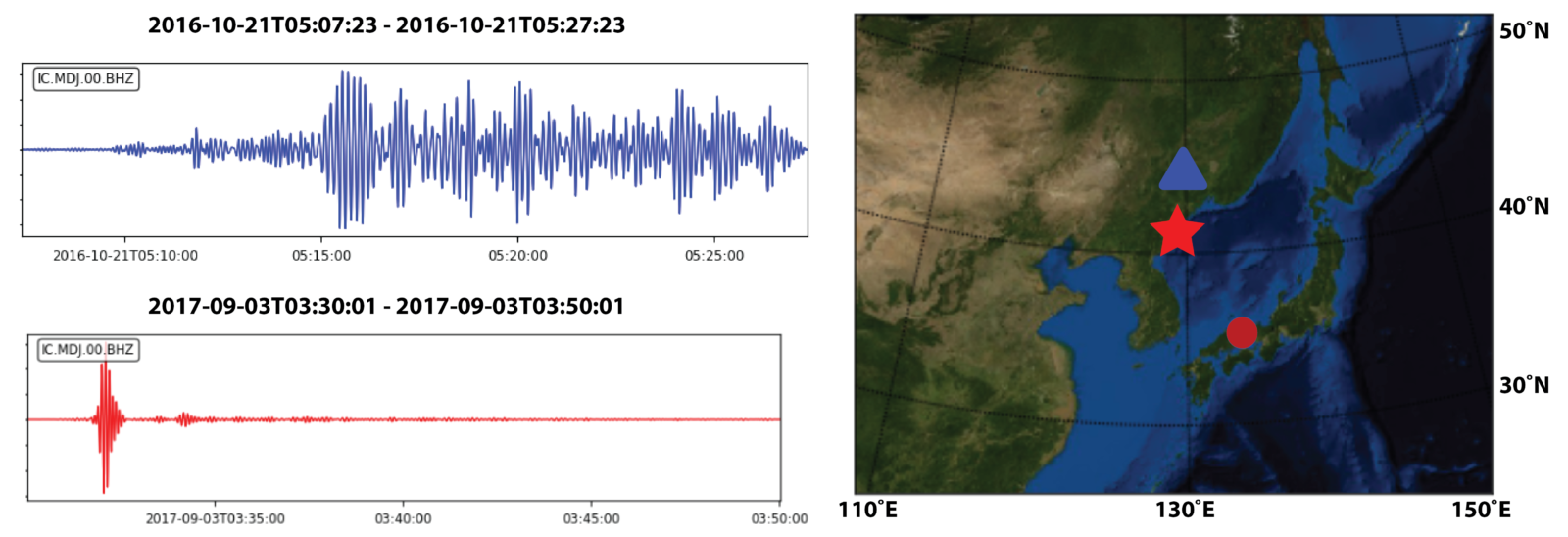
The second method concerns the observation of the waveform generated by the event. Because the seismic energy of an explosion pushes outward in all directions, the result is strong P (compressional) waves and weak S (shear) and Surface waves. In contrast, rapid slip motion during an earthquake typically generates weak P-waves and strong S and Surface waves that are of higher amplitude and slower than P-waves (Figure 4).

Two seismograms detected by a seismic station in South Korea (green triangle on the map); one from a magnitude 4 earthquake that occurred in 2004 (blue) and another one from a 2017 nuclear test that was estimated to be equivalent to magnitude 6.3 earthquake (red). Compared to the earthquake, the P waves of the nuclear test are much more prominent.
This is not new!
Seismometers have been recording signals from such types of explosions for decades. Famous examples include the explosion on the Chinese port of Tianjin (2015) or the Texas City Disaster in 1947, both of which have been observed on the global seismic network [Ref 9]. It has been a major branch of seismology to study and analyze the waveforms resulted from such explosions. In fact, part of the interest in seismology, as well as the investment in seismic networks all across the globe, resulted from the desire to monitor the development and testing of nuclear weapons. The seismograms resulting from the explosions were analysed to estimate the size and type of nuclear warheads that were being tested in another country. From 1945 until the present day, over 2100 nuclear tests have been performed by 8 nations (the US, UK, Soviet Union, France, China, India, Pakistan and North Korea), which have been recorded by seismic networks extending all across the globe [Ref 10].
Throughout the 20th century, several nuclear test ban treaties were signed, culminating in the signing of the Comprehensive Nuclear Test Ban Treaty which was adopted by the United Nations General Assembly on 10 September 1996 [Ref 7]. Although not officially come into force because eight nations (notably including the US) have not ratified it [Ref 8], the treaty has effectively resulted to the end of nuclear testing on a global scale. The only country still performing nuclear tests is North Korea, where the most recent test (3 September 2017) had an estimated equivalent magnitude of 6.1 [Ref 11]. Since an increase in magnitude by 1 unit corresponds to an increase in energy of roughly a factor 30, this nuclear test was at least 10.000 times more powerful than the M 3.4 Beirut explosion!
Largest accidental artificial non-nuclear explosions by magnitude [Ref 9]
- Halifax Explosion Halifax, Nova Scotia, Canada 6 December 1917 High explosives
- 2020 Beirut explosions Beirut, Lebanon 4 August 2020 Ammonium nitrate
- RAF Fauld explosion RAF Fauld, Staffordshire, United Kingdom 27 November 1944 Military ammunition
- Port Chicago disaster Port Chicago, California, United States 17 July 1944 Military ammunition
- Oppau explosion Ludwigshafen, Germany 21 September 1921 Ammonium sulphate and ammonium nitrate fertiliser
References
1. https://youtu.be/n-3GJwy6EI4?t=18
2. https://www.bbc.com/news/world-middle-east-53668493
3. https://www.emsc-csem.org/Earthquake/earthquake.php?id=882410#testimonies
4. USGS Earthquake Hazards programme event page
5. https://www.emsc-csem.org/Earthquake/earthquake.php?id=882410
6. Earthquake or Bomb, how do scientists tell the difference? IRIS Consortium
7. https://www.ctbto.org/the-treaty/
8. https://www.un.org/disarmament/wmd/nuclear/ctbt/
9. https://en.wikipedia.org/wiki/Largest_artificial_non-nuclear_explosions#Largest_accidental_artificial_non-nuclear_explosions_by_magnitud
10. https://www.ctbto.org/specials/who-we-are/
11. https://www.ctbto.org/the-treaty/developments-after-1996/2017-sept-dprk/
This blog post was written by Akash Kharita a Master student from the Indian Institute of Technology Roorkee
with revisions from ECS representative Nienke Bloom, Janneke De Laat and Maria Tsekhmistrenko.

Evrim Yavuz
I’m working on the distinction between earthquake and artificial vibrations. I have published the short report of August 4, 2020 Beirut Port, Lebanon explosion. I used 6 seismic stations that located in southern Turkey and calculated the local magnitude as 4.1. If you would like to view my report, here is the link: https://www.researchgate.net/publication/343449850_August_4_2020_Beirut_Port_Lebanon_Explosion_-_Short_Report
Esraa alshami
Thanks a lot ..This scientific paper is important to me because I study at the Higher Institute for Seismic Research and Studies..and the distinction between detonation and earthquake is the core of my research
Brigitte Knapmeyer-Endrun
Thanks for this interesting post. I think there is an issue with the last figure, though. The triangle shown on the map is not located in South Korea, but in China, which would mean it’s much closer to the North Korean test site than to the quake in Japan, which would have a big influence on waveforms, e.g. travel time of seismic phases and accordingly length of the seismogram, development of surface waves… (Actually, station MDJ of network IC, as indicated on the seismograms, is indeed in China). So the differences you are pointing out here are not simply related to different source types. A station in South Korea, on the other hand, would be at approximately the same distance from the two, making the waveform comparison more meaningful.
James
AZF surface detonation in 2001 France gave an average magnitude of Ml 3,3 (see
slideshare james1er)
The equivalent TNT was in the range of 75000Kg that is approx 1/10 Beirut.
The first Beirut estimates were Ml 4,5 and now finalized worldwide at 3,4.
Knowing that most of the crater is on sea, the seismic footprint was far more
important compared to a similar crater on solid earth.
I am not an expert but I am pretty sure that Beirut true magnitude is around 3,7