The largest earthquake during the second month of 2021 occurred on February 10th in the western Pacific, specifically to the southeast of the Loyalty Islands and New Caledonia, a seismically active region due to the convergence between the Australian Plate subducting beneath the Pacific Plate (Figure 1). This earthquake (Mw 7.7) was preceded by at least three foreshocks earthquakes M>5.5, which occurred one hour before the mainshock (see green dots in Figure 1). All of them were shallow and thrust faulting earthquakes.
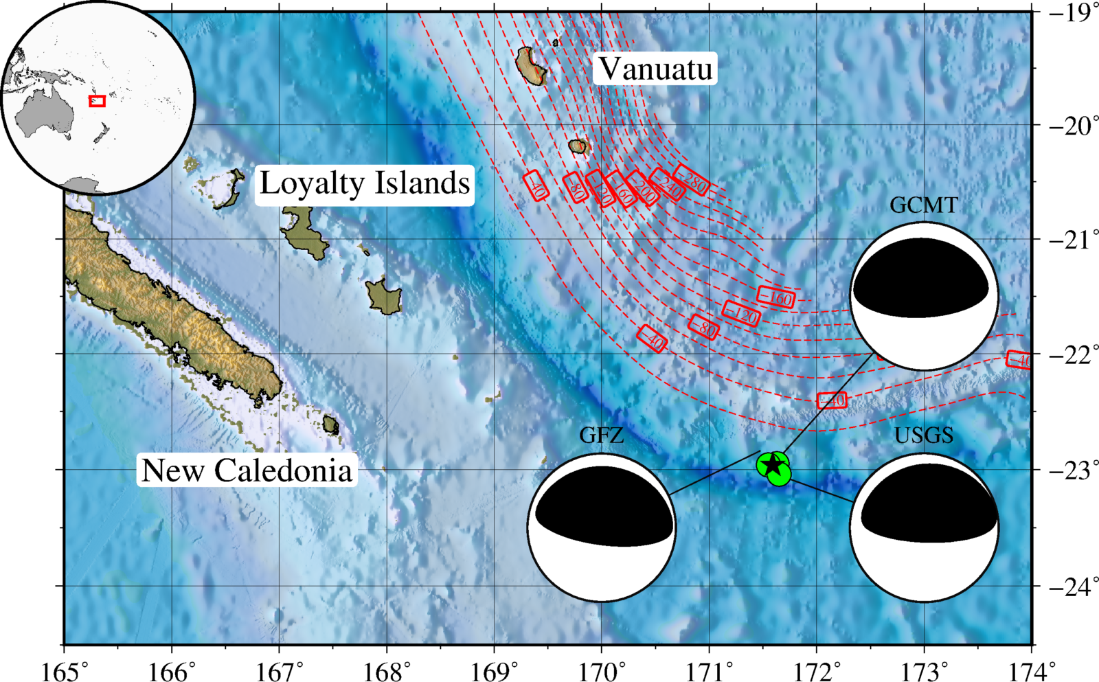
Figure 1 | Location of the Loyalty Islands earthquake (GCMT hypocenter, black star) and Focal mechanism calculated by GCMT, GEOFON and USGS. The green dots represent the three foreshock locations that occurred one hour before the mainshock.
The moment tensor solutions show an interesting thrust/reverse faulting mechanism. Based on their hypocenter and mechanism, the earthquake can be classified as a shallow subduction interface event in close vicinity with the New Hebrides trench.
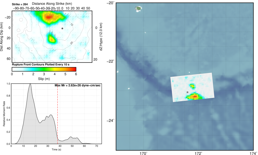
Figure 2 | Coseismic slip distribution model and source-time function (Credits: USGS).
Further information provided by USGS like the coseismic slip distribution and source-time function (Figure 2), reveals an up-dip propagation with the main asperity located near the trench with a maximum slip of six meters. The seismic energy was released during approximately 40 seconds, with a possible second rupture that future studies can discriminate.
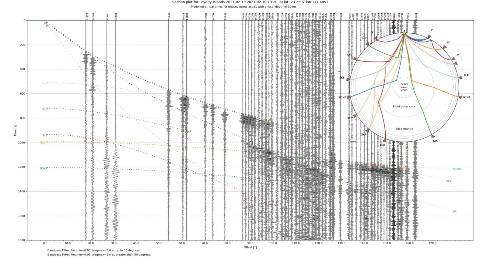
Figure 3 | Section from the M7.7 earthquake recorded on the global Raspishake network around the globe (Credits: Mark Vanstone @wmvansone).
Due to the great energy released by the earthquake Mw 7.7, seismic waves were recorded by the seismic network around the globe. Figure 3 shows a section plot for the Loyalty Island event recorded by Raspberry shake sensors, from which we can visualize the different phases generated by reflection and refraction of seismic waves propagated through the Earth’s interior.
Following an earthquake rupture, the seismic waves radiated from the near-source travel around the world and were recorded by global seismic networks. Figure 4 show the ground motion visualization in the global seismograph network.
Animation 1 | Ground motion visualization of waves through the globe (Credits: Giuseppe Petricca @gmrpetricca, code by @IRIS_EPO).
A location deep problem
The preliminary results about the location and magnitude of this event generated open discussions about the origin of the seismic source. First reports claimed a shallow outer-rise event in the Australian Plate due to their location. However, later results indicate an earthquake rupture on the shallow portion of the megathrust, a priori information used to estimate the preliminary slip distribution models.
Although the preliminary estimation for earthquake magnitude varied in a range between M 7.1 to M 7.9, most of the seismological agencies converge to an Mw 7.7 event, which was located at shallow depths around 22 to 29 km. Also, the combination of shallow depth and the thrust mechanism can result in tsunami waves. However, the maximum amplitudes for the tsunami were recorded in Lenakel, Vanuatu and Great Barrier Island, New Zealand with ~0.75 m heights according to PTWC. Fortunately, due to their remote locations, far from urban areas, no damage or fatalities were reported for both, earthquake and tsunami hazards.
February earthquakes
Loyalty Islands earthquake, Vanuatu – 10th February – M7.7
Namie earthquake, Japan – 13th February – M7.1
Chile Rise earthquake – 3rd February – M6.7
Note: This blog corresponds to a brief seismological review of the preliminary results about a mainshock event and seismic activity. An earthquake can be disastrous for neighbouring towns and people. When our team picks an “Earthquake of the month” (now “Earthquake Watch”) it is important to keep in mind that we are not looking for the most mediatic and deadly one. We are generally looking for regions where we can learn more about the seismic hazard, seismotectonic background, and social impact, which we put together with preliminary contributions. Understanding the seismic hazard is one way to address disaster risk reduction and develop resilient cities. As EGU Seismology ECS Team, our thoughts are with the earthquake struck communities in this challenging time.
This blog post was written by ECS representative Javier Ojeda
with revisions from ECS representative Maria Tsekhmistrenko