On September 28, 2018, a powerful 7.5-magnitude earthquake and an unexpected tsunami shook the Indonesian island of Sulawesi, leaving behind catastrophic results and open questions among geoscientists. How come this event is having such an impact on the scientific community?

Figure 1. Map of Indonesia, showing the four Greater Sunda Islands, the location of the 2018-09-28, Mw7.5 Palu earthquake and its focal mechanism.
What we know so far
On Friday afternoon (at around 5pm Western Indonesian Time) the Minahassa Peninsula on Sulawesi island was struck by a Mw7.5 earthquake (Figure 1) [1]. The main shock occurred on the strike-skip Palu-Koro fault, one of the most active structure in Sulawesi [5]. The epicenter of the quake is located 27 kilometers northeast of Donggala, at a depth of 10 km [1]. By looking at the aftershocks distribution from within 4 days after the Mw7.5 event (Figure 2), we can approximately estimate a rupture extent ranging from a few kilometers to the North of the epicenter over about 200 km to the South [2]. The rupture area is thus roughly 200x20km, mainly located South of the hypocenter and ending in the city of Palu (Figure 2). Nothing surprising by now, but the intriguing part is coming.
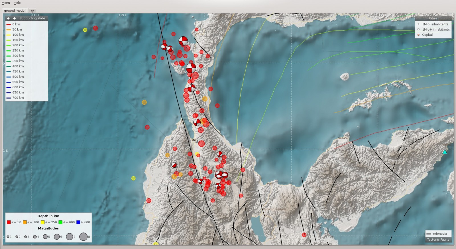
Figure 2. Aftershocks distribution (coloured circles) from within 4 days after the Palu earthquake event occurred on 28 September. Hypocentral depth and magnitude are shown respectively with the colour scale and the circle size. The Palu-Koro fault is indicated in black. The mainshock event lies in the centre of a large aftershock cloud stretching over more than 200 km in N-S direction. Picture taken from Global Earthquake Monitoring Processing Analysis (GEMPA)[2].
By looking at the source time function of the Palu earthquake (Figure 3), we can deduce that the event took about 30s to rupture a length of 200km, suggesting a supershear rupture velocity. While most seismic ruptures propagate at speeds lower than the S-wave speed, supershear ruptures propagate at speeds between the P and S waves. Supershear ruptures are extremely rare events which, in the past, mostly propagated on very smooth part of strike-slip faults [12]. Coincidentally, first estimates of surface displacements along the Palu-Koro fault show a very sharp offset between the two sides of the fault, suggesting that the rupture propagated on a linear, very smooth segment of the fault.
“This is the most sharp and linear earthquake surface displacement I’ve seen since 2013 Balochistan eq!” says geologist Sotiris Valkaniotis on his twitter account. And the image [Figure 3] has already gone viral on the net. Further study will be necessary to confirm if this event is in fact supershear.
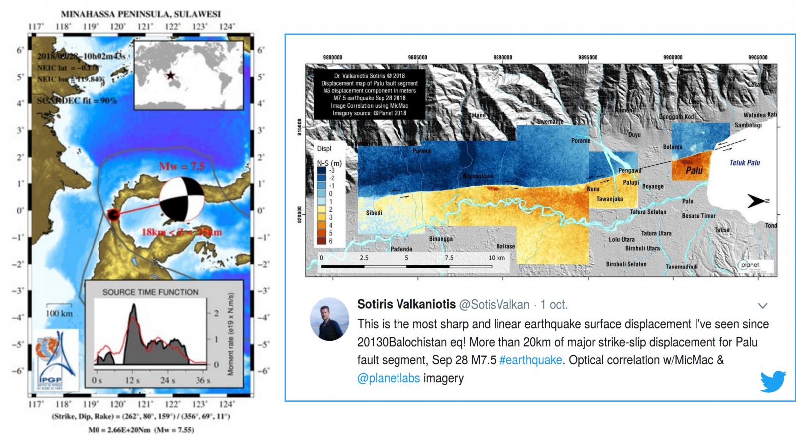
Figure 3. On the left: source time function of the Mw7.5 Palu earthquake and its focal mechanism. The Palu earthquake took about 30s to rupture a length of about 200km along the Palu-Koro fault segment. Picture from GEOSCOPE Web Portal [3]. On the right: displacement map of the Palu-Koro fault. Colorscale from red to blue represents the North-South displacement in meters. Picture realized and posted by geologist Sotiris Valkaniotis on his twitter account.
Tectonic setting
Sulawesi is one of the Greater Sunda Islands [4], a group of four large islands within the Malay Archipelago including Java, Sumatra and Borneo (Figure 1). An intricate pattern of faulting scars the land: collisional orogenies, subduction zones, rift systems and transform faults pile up in this area [5], making the island prone to earthquakes.
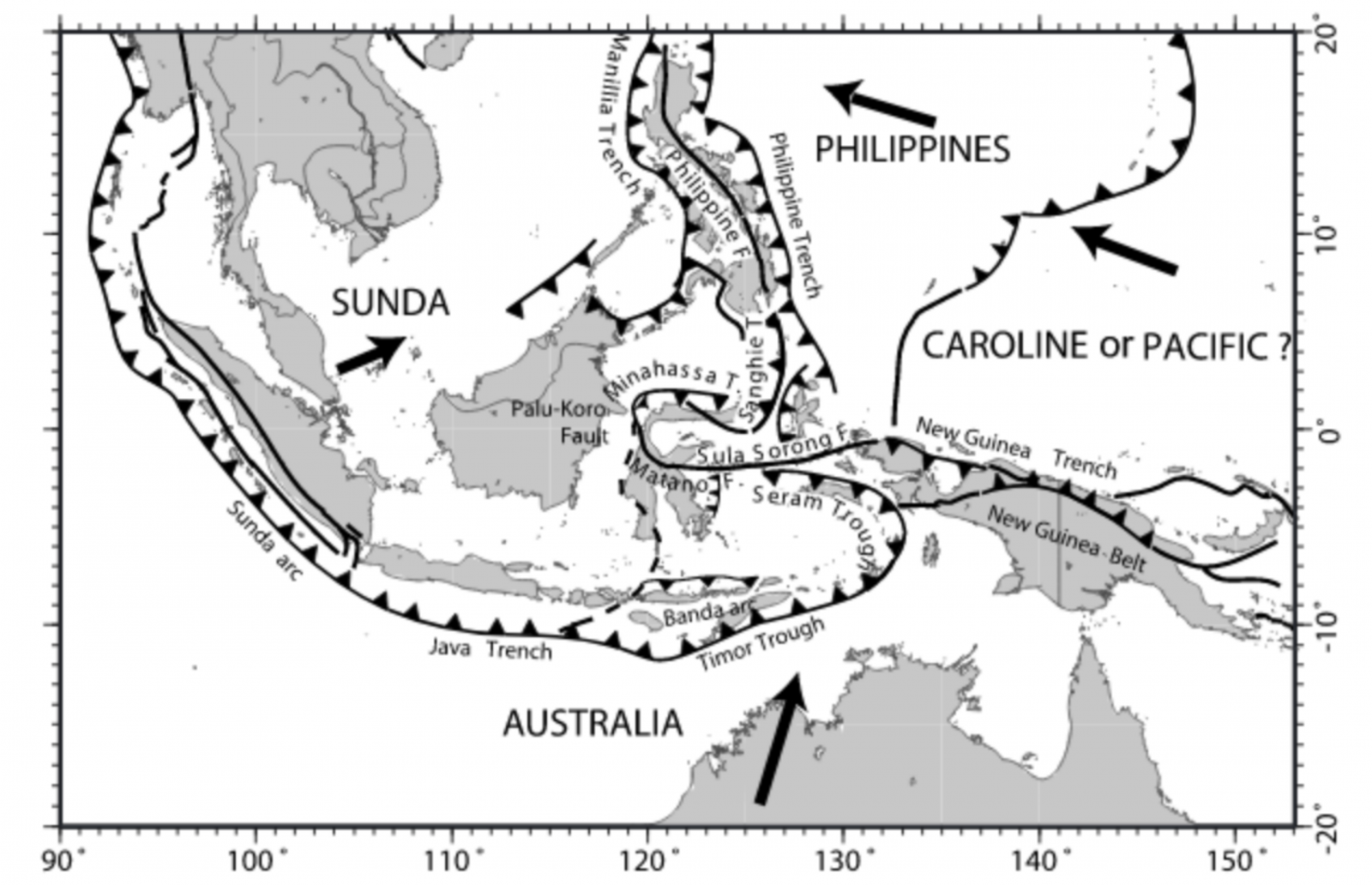
Figure 4. Tectonic setting of the Sunda–Australia–Philippine–Pacific plates junction area. Arrows depict the far-field velocities of the plates with respect to Eurasia. Picture taken from Socquet et al. (2006)[5]
From a tectonic point of view, Sulawesi lies within the triple junction of the Australian, Philippine and Sunda plates and accommodates the convergence of continental fragments with the Sunda margin [5]. In particular, the southwestern part of Sulawesi rotates anticlockwise respect to the Sunda Plate; the northeastern Manado Block and the central North Sula Block move toward the NNW and rotate clockwise; the East Sulawesi is pinched between the North Sula and Makassar blocks (Figure 4).
Palu
The left-lateral strike-slip Palu-Koro fault is the main active structure in Sulawesi: it bisects the island and connects to the Minahassa Trench, where subduction occurs. The Palu-Koro fault zone accommodates 42 mm/yr and shows a transtensive behavior more complex than a simple strike [5]. This deformation is most likely explained by the presence of a pull-apart structure that may be localized around the Palu area (Figure 5)[5].
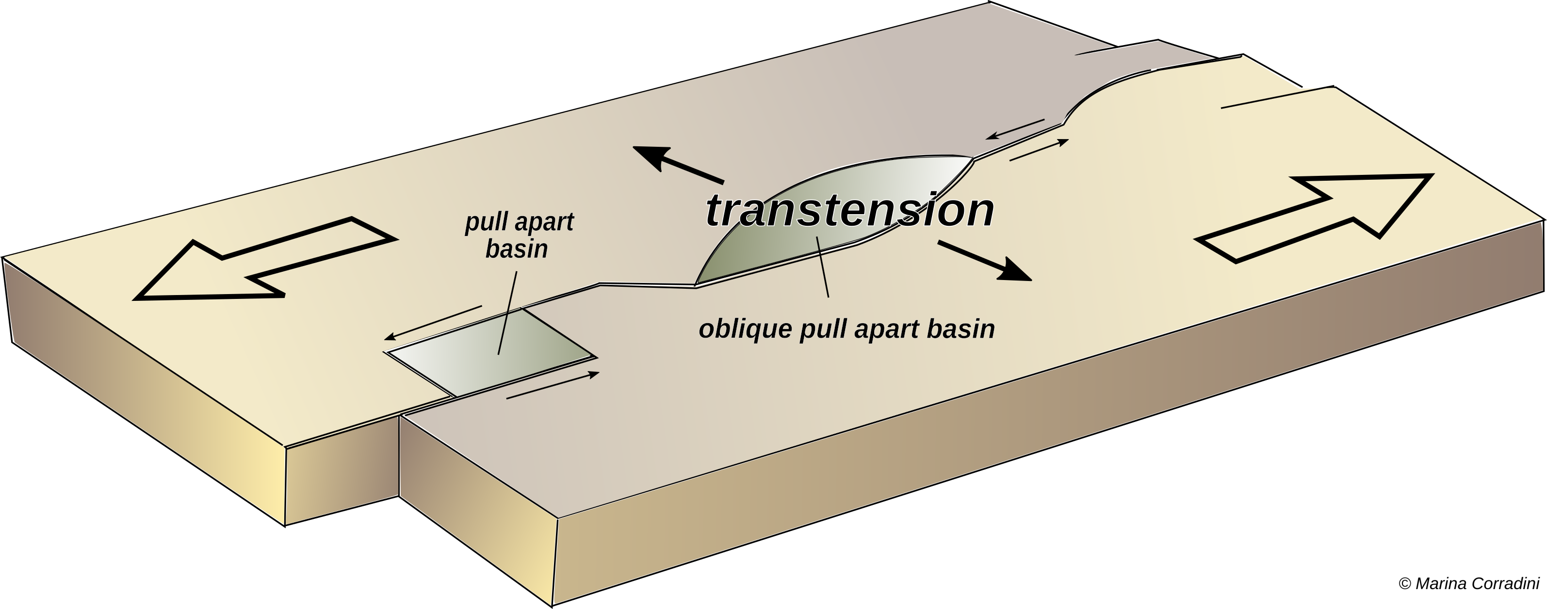
Figure 5. Sketch showing a transtensional state of a rock. It is unlikely that a deforming body experiences ‘pure’ extension or ‘pure’ strike-slip. Many tectonic regimes that were previously defined as simple strike-slip shear zones are by now assumed as transtensional. As such, transtensional regions are characterised by both extensional structures (normal faults, grabens) and wrench structures (strike-slip faults).
‘Surprise Tsunami’
Following the Mw7.5 earthquake, a series of tsunami waves hit Palu, Donggala and Mamuju decimating the coastline, flattening homes, destroying several inland areas in Central Sulawesi [watch the video below]. Indonesian Agency for Meteorology, Climatology and Geophysics (BMKG) initially issued a tsunami warning but eventually revoked it.
<< The decision was based on visual monitoring and further monitoring using the equipment [tsunami detection buoys] at sea for 30 minutes. The BMKG did not see any significant change in the sea level. That’s why they ended the alert >> BNPB spokesman Sutopo Purwo Nugroho said in a statement [6].
The eastern Indian Ocean basin is a region of high earthquake and volcanic activity, so tsunamis should come as no surprise. Yet, geoscientists are doubtful. Could the Palu earthquake alone have generated such a big tsunami wave?
Eighteen tsunamis have crashed in the area since 1900 by large shallow earthquakes [7] and among them we can’t forget the tsunami that hit the Indian Ocean following the December 26, 2004, earthquake in Sumatra [8]. The controversy about the ‘surprise’ tsunami however arises when we look at the tectonic setting of Sulawesi island and the devastating effects documented on the coastline.
Tsunami waves are generated by a sudden vertical motion of the seafloor. They are therefore mostly triggered by dip-slip earthquakes where the block of rock on top of the fault, also called the hanging wall, moves up, which pushes the overlying water column up [watch the animation below]. But the Palu earthquake occurred along a strike-slip fault, meaning the motion was mainly horizontal. It is therefore very unlikely that such a large tsunami could have been originated by earthquake rupturing alone.
This simplified animation illustrates the tsunamis generation in sudbuction zones. Tsunamis generally occur after a megathrust earthquakes and thus follow vertical movement in the crust. (© Marina Corradini)
Scientists’ best guesses?
¤ A submarine landslide: triggered by the main shock, a submarine tectonic displacement may have generated or augmented the tsunami waves.
¤ A complex bathymetry: the seafloor in the Palu Bay is not flat. If there is a slope, even an horizontal motion of the seafloor can produce an apparent vertical motion [9].
There is still no evidence that any of those hypotheses (landslide or seafloor slope) is the actual reason. They could be both too. Besides, the intensity of the tsunami seems to be more related to the shape of the Bay, which naturally acts as a funnel for the tsunami waves. As yet, a straightforward interpretation seems hasty and further analysis should come in aid.
Rescue and damages: what now?
The confirmed death toll from the Palu earthquake and tsunami has risen to 1,407 [10] together with thousand of buildings destroyed and over 61,000 people displaced [11]. The full scale of damages in the region can already be guessed by watching the dramatic pictures and videos spread online. First aid has already been mobilized through several nonprofit organizations and charities, and everyone’s help is essential in these circumstances.
This post was written by Marina Corradini, with revisions from Maria Tsekhmistrenko and Lucile Bruhat
Maria Tsekhmistrenko is a PhD student at the University of Oxford. She works on the velocity structures beneath the La Reunion Island from the surface to the core mantle boundary. You can reach her at mariat[at]earth.ox.ac.uk
Lucile Bruhat is a post-doctoral researcher at the Ecole Normale Supérieure (ENS) in Paris. She works on the description and understanding of the physical processes that underlie the earthquake cycle, through geodetic/seismological data analysis and numerical modeling. You can reach her on Twitter at @seismolucy
Acknowledgements:
The author thanks the IPGP Seismology and Tectonic Labs for the useful material and discussion.
__________________________________________________________________________
References :
[1] https://ds.iris.edu/wilber3/find_stations/10953070