Haven’t you heard about the recent major earthquakes which stroke the globe? No worries, the ECS-reps will post a quarterly report with basic information about the latest earthquakes you can’t miss. Let’s start with June, July and August 2018.
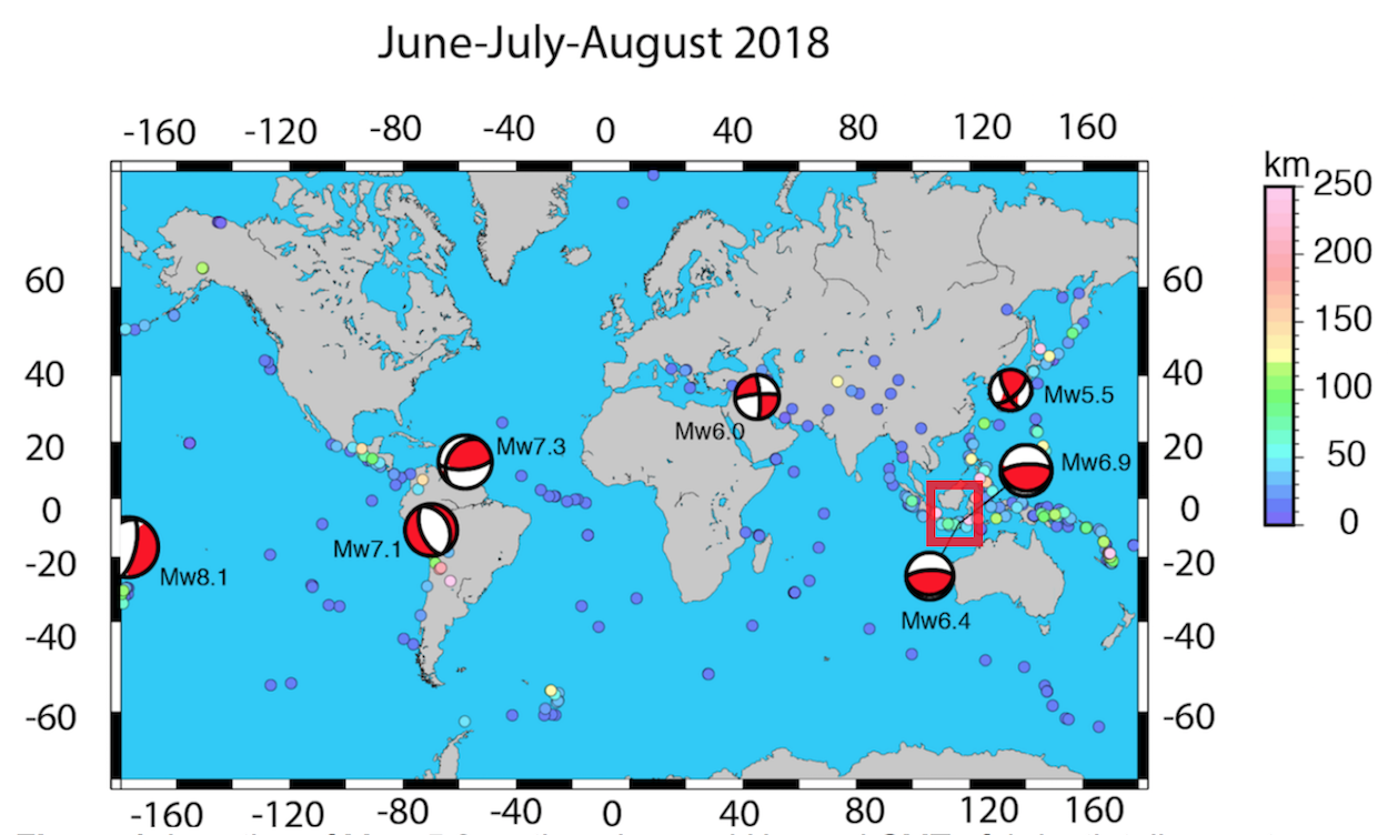
Figure 1. Location of Mw> 5.0 earthquakes (small circles with colour scale showing the depth). Harvard CMT of death tolls events and the greatest event of magnitude Mw8.1 recorded in the period June-July-August.
Between the 1st June and the 31st August, 425 earthquakes with magnitude Mw above 5.0 were recorded by the international network broadband seismic instruments and listed in the USGS catalogue (figure 1). Among them, 32 events showed a magnitude Mw> 6.0 and 4 large earthquakes (Mw>7.0) were observed.
Among these 425 earthquakes, we can count 200 shallow events (<20 km) and 76 deep earthquakes (>100 km). During this last quarterly, the seismic activity in the lesser Sunda islands (red square on figure 1) was very active, as we will see later in this report.
A zoom on South East Asia and Central America
Subduction zones in South East Asia and Central America knew a strong activity this summer in comparison with other regions. Let’s have a look at South America: we can observe 2 large earthquakes occurred in August (Venezuela on the 21st and Peru on the 24th) few days after the Fiji earthquake (Mw8.1) on the 18th (Table 1). Could we argue that the Fiji earthquake triggered the Venezuela earthquake (Mw7.3) and that, in turn, the Venezuela earthquake triggered the Peru earthquake (Mw7.1)? A recent paper by O’Malley et al. [2018] supports the idea that a large earthquake can trigger teleseismic events[1].
Table 1. List of death tolls in the period June-July-August.
| Location | Date | Time (UTC) | Mw | Mechanism |
| Osaka Prefecture* | 17/06/2018 | 22:58:35 | 5.5 | Strike slip |
| Lombok island* | 28/07/2018 | 22:47:37 | 6.4 | Dip slip (thrust) |
| Lombok island* | 05/08/2018 | 11:46:37 | 6.9 | Dip slip (thrust) |
| Lombok island* | 19/08/2018 | 14:56:26 | 6.9 | Dip slip (thrust) |
| Fidji islands | 19/08/2018 | 00:19:37 | 8.1 | Dip slip (thrust) |
| Venezuela | 21/08/2018 | 21:32:42 | 7.3 | Dip slip (thrust) |
| Peru-Brazil | 24/08/2018 | 08:04:07 | 7.0 | Dip slip (thrust) |
| Kermansha* | 25/08/2018 | 23:06 | 6.0 | Strike slip |
In spite of the progress in engineering seismology and a better awareness of the rules of conduct in case of earthquake, some of these events always kill relatively too many people. That’s why we call them “death toll”.During this summer, 564 persons were killed after death tolls in Osaka in June (Mw5.5), in Lombok-Sumbawa in July (Mw6.4) and Kermanshah on August (Mw6.0).
June 2018
June was characterized by 120 seismic events with magnitude Mw above 5.0 and only 1 event with Mw6.1 in Vanuatu. This month was also characterized by a strong volcanic activity in Hawaii (26 events with Mw above 5.0 were recorded).
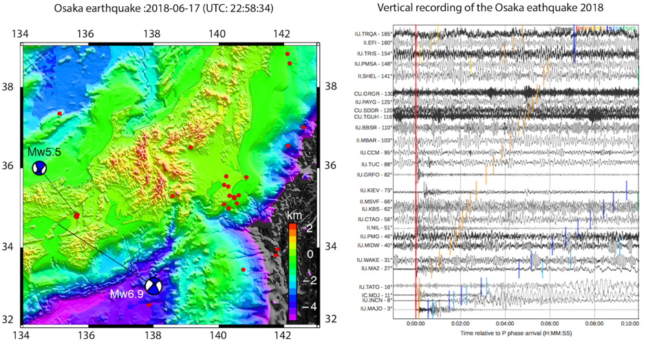
Figure 2.a. On the left: Location and CMT Harvard Solution of Osaka quake (17 June 2018) and Kobe quake (19 January 1995). Red dots correspond to earthquakes with magnitude Mw>5.0. On the right: Seismograms of the Osaka earthquake from the global seismic network.
On 17 June, a Mw5.5 hit the northern region of Osaka Prefecture (figure 2.a.) where more than 9 million people live [2]. In this area, the seismicity is controlled by a system of strike slip faults [3] which accommodate the convergence of the Philippine plate and the Eurasian plate. The seismic activity of this region is relatively quiet in comparison with the northern part of the islands and subduction earthquakes. Nevertheless, the region was struck by 2 great historical earthquakes (Mw>7.0) in the last 500 years (1995 in Kobe Mw7.2 and 1596 in Keicho Fushimi M7.5) [4,5]. In 1995, the Mw 7.2 Kobe earthquake broke the 40 km long and 20 km wide fault plane of the Arima-Takatsuki fault zone (ATFZ). This quake killed 6,433 people and cost $100 billion.
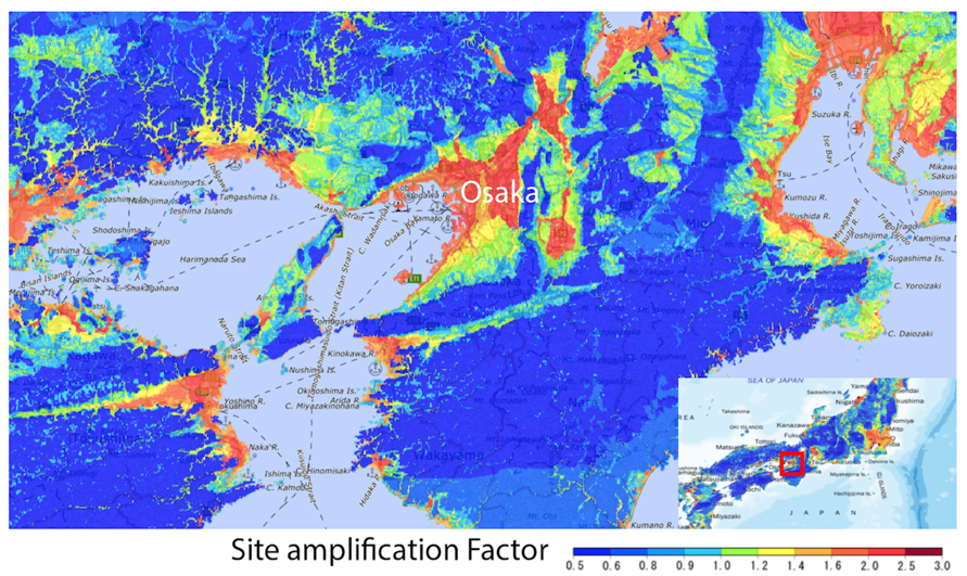
Figure 2.b. Site amplification factor map of Osaka Prefecture (source: http://www.j-shis.bosai.go.jp/)
The 17 June event was located in the same area where a large earthquake was expected in the last 30 years after the 1995 earthquake [6]. Seismic hazard studies in this region show a strong site amplification of the area to ground motion (figure 2.b.). The relatively low magnitude event was amplified in some areas [7] and became a death toll due to collapsing concrete walls [8]: a danger knew since the Miyagi earthquake (Mw7.4) in 1978 [9], where several aspects of engineering seismology and soil behaviour started to be developped in Japan.
July 2018
July was characterized by 132 seismic events with magnitude Mw above 5.0 and 9 events higher than 6.0. Volcanic activity in Hawaii continued during this month with about 22 events recorded. As in June, July also knew a death toll event.
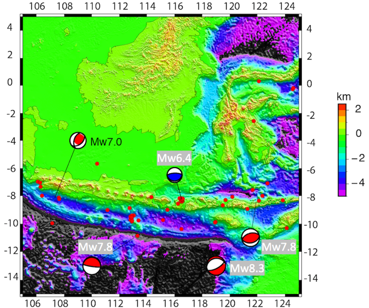
Figure 3. Location and Harvard CMT solution of the Lombok earthquake (Mw6.4) and historical great earthquakes (Mw>7.0) in the area. Local seismicity (red dot) during the month. Death tolls are shown in grey.
On the 28th July, a magnitude Mw6.4 event [10] shook Lombok island (Indonesia) killing 20 persons and injuring 401 (figure 3). Lombok island is a paradisiac island east of Bali with a population of about 3.4 million people. The region had previously known large earthquakes along the Sunda subduction zone (Table 2): in 1977 in Sumba (Mw8.3), where 177 people were killed and 1,100 injured; in 1994 in Java (Mw7.8), with 250 killed and a triggered tsunamis [11,12]; in 1992 in Flores islands (Mw7.8) with 2,500 deads.
Table 2. Death tolls along the Sunda subduction zone.
| Location | Date | Mw | Mechanism |
| Sumbawa islands | 19/08/1977 | 8.3 | Dip slip (Normal) |
| Flores islands | 12/12/1992 | 7.8 | Dip slip (thrust) |
| Java islands | 03/06/1994 | 7.8 | Dip slip (thrust) |
| Lombok islands | 28/07/2018 | 6.4 | Dip slip (thrust) |
A zoom on the Lombok island
The Mw6.4 Lombok event nucleated within the megathrust subduction zone in the south and the Flores back arc thrust fault in the north [13]. Even if this event occurred in a shallow part of the crust (about 15 km deep), no tsunami was reported afterwards. Recently, Koulali et al. (2016) [14] show that, from GPS measurement analysis, this region could expect a large earthquake (Mw>7.0) within the next years, implying that the Mw6.4 event could change the recurrence time of this kind of events in the future.
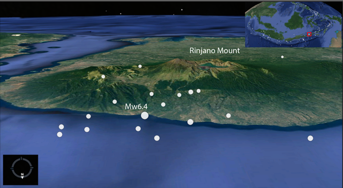
Figure 4.a. Seismicity across the Lombok island and the location of the Mw6.4 event (28th July 2018).
Lombok island is also characterized by the presence of an explosive volcano (Rinjano, 3726 m) which knew its last eruption in 2016 [15]. The 2018 earthquake did not trigger any eruption but rather a landslide of the northern face where the seismicity was mainly concentrated (figure 4.a.). More than 1,200 hikers were stuck on the volcano [16], 5,448 houses were destroyed and more than 10,000 were displaced [17] (figure 4.b.).

Figure 4.b. Damages after the Lombok event (source: AFP)
August 2018
August was characterized by 168 seismic events with magnitude Mw above 5.0 and 22 events higher than 6.0 (with 4 large earthquakes). The low volcanic activity in Hawaii continued during this month with about 1 event recorded. On the 5th August a Mw6.9 event (figure 5) stroke Indonesia again in the same area [18,19].
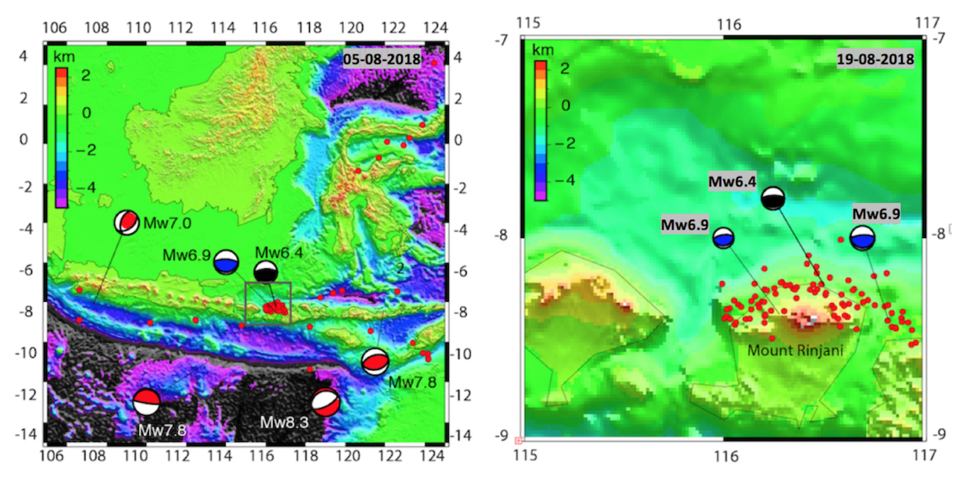
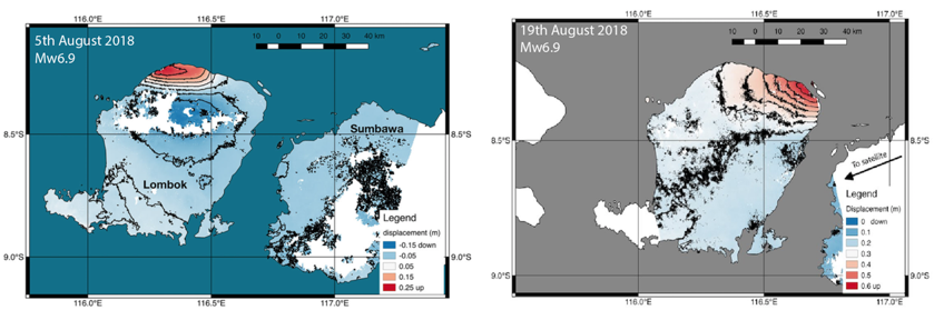
Figure 5. At the top: Location and Harvard CMT solution of the Mw6.4 earthquake in July (in black) and the Mw6.9 in August (in blue). In red, Harvard CMT solution of historical great earthquakes (Mw>7.0) and local seismicity (red dots) during the month of August. At the bottom: Map of the ground deformation from satellite data analysis. (source: NASA/JPL Caltech)
August was the worst month of the year with 513 killed. Strong seismic activity [20,21] is observed on Lombok island generating a series of landslides but no eruption was reported. This Mw6.9 event also caused the uplift of the northern part of the island (maximum uplift of about 25 cm) [22,23]. Another event hit Lombok island 2 weeks later on the 19th August with a Mw6.9. This event also produced an uplift in the northen part, but affecting another fault.
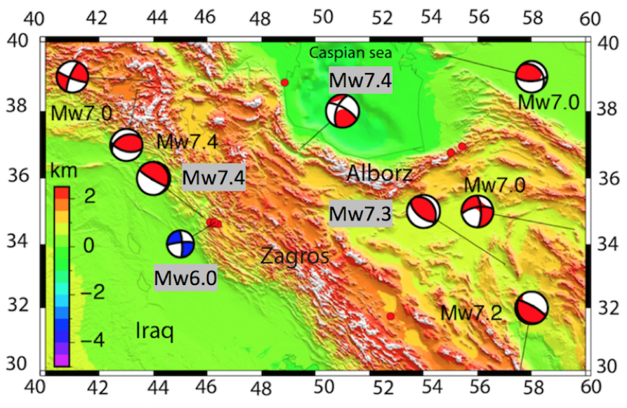
Figure 6. Location and Harvard CMT of Kermansha earthquake (M6.0 on 25th August) and historical great earthquake in the area. Death tolls are shown in grey.
August also recorded the biggest event of the year with a Mw8.1 event (figure 1 and Table 1) near Fiji [21] without damaged, thanks to its depth (~ 560 km). Later in the month, on the 28th August, another death toll of Mw6.0 (3 deaths and 243 injured people) hit Iran (figure 6).
Table 3. List of death tolls in Iran
| Location | Date | Mw | Mechanism |
| Tabas | 16/09/1978 | 7.3 | Dip slip (thrust) |
| Manjil Rudbar | 20/06/1990 | 7.4 | Strike slip |
| Kermanshah | 12/11/2017 | 7.4 | Dip slip (thrust) |
| Kermnshah | 25/08/2018 | 6.0 | Strike slip |
This region has already been stroke in the past: on the 12th November 2017, a Mw7.3 event killed about 630 persons [24,25]; eastern, the Manjil Rudbar quake (Mw7.4) in 1990 (figure 6) killed between 35,000 and 50,000 people [26,27]. This strong seismic activity in Iran is due to thecollision zone between the Arabia plate and the Eurasian plate, originating the Zagros Fold thrust belt, and the presence of several active strike slip faults. As we can see on figure 6, the region was stroke by 8 large earthquakes (Mw7.0) in less than 50 years and 4 death tolls listed in Table 3.
This post was written by Walid Ben Mansour, with revisions from Lucile Bruhat and Marina Corradini
Walid Ben Mansour is a post-doctoral researcher at Macquarie University, Australia. He works on multi-observable probabilistic tomography for different targets (mining, seismic hazard). You can reach him at walid.benmansour[at]mq.edu.au
Lucile Bruhat is a post-doctoral researcher at the Ecole Normale Supérieure (ENS) in Paris. She works on the description and understanding of the physical processes that underlie the earthquake cycle, through geodetic/seismological data analysis and numerical modeling. You can reach her on Twitter at @seismolucy
____________
References
[1] O’Malley et al.(2018). Evidence of Systematic Triggering at Teleseismic Distances Following Large Earthquakes. Scientific Reports, 8 (1) DOI: 10.1038/s41598-018-30019-2
Osaka Earthquake
[2] Powerful quake shakes Osaka: three killed, 307 injured. The Asahi Shimbu. http://www.asahi.com/ajw/articles/AJ201806180009.html
[3] Powerful quake that jolted northern Osaka Pref occurred near fault zone.The Mainichi. https://mainichi.jp/english/articles/20180618/p2a/00m/0na/015000c
[4] Kanaori and Kawaka (1996). The 1995 7.2 magnitude Kobe earthquake and the ArimaTakatsuki tectonic line: implications of the seismic risk for central Japan. Engineering Geology,43, 135–150
[5] Lin et al. (1988). Paleoseismic events and the 1596 Keicho-Fushimi large earthquake produced by a slip on the Gosukebashi fault at the eastern Rokko Mountains, Japan.The Island Arc,7,621–636.
[6] Today’s deadly Japan earthquake could be related to the 1995 Kobe earthquake. Temblor blog- http://temblor.net/earthquake-insights/todays-deadly-japan-earthquake-could-be-related-to-the-1995-kobe-earthquake-7347/
[7] Soft soil added to intense shaking of quake on Osaka plain. The Mainichi. https://mainichi.jp/english/articles/20180619/p2a/00m/0na/022000c
[8] Osaka quake highlights dangers posed by concrete-block walls. The Japan Times- https://www.japantimes.co.jp/news/2018/06/19/national/osaka-quake-highlights-dangers-posed-concrete-block-walls/#.W5daOi2Q0Wo
[9] An investigation of the Miyagi ken oki, Japan, earthquake of June 12.1978. NBS Special publication-592.
Lombok Earthquake
[10] NTB declares seven-day state of emergency after earthquake that claims 17 lives- Jakarta Post- http://www.thejakartapost.com/news/2018/08/01/ntb-declares-seven-day-state-of-emergency-after-earthquake-that-claims-17-lives.html
[11] Gusman et al. (2009). Analysis of the tsunami generated by the great 1977 Sumba earthquakes that occurred in Indonesia. Bulletin of the Seismological Society of America,99 (4),2169–2179.
[12] Abercrombie et al. (2001). The 1994 Java tsunami earthquake: slip over a subducting seamount. Journal of Geophysical Research,106 (B4),6595–6607.
[13] Two types of tectonic plate activity create earthquake and tsunami risk on Lombok. The conversation- https://theconversation.com/two-types-of-tectonic-plate-activity-create-earthquake-and-tsunami-risk-on-lombok-101177
[14] Koulali et al. (2016). Crustal strain partitioning and the associated earthquake hazard in the eastern Sunda-Banda arc. Geophysical Research letter, 43(5)
[15] Indonesia evacuated tourists after volcano eruption. BBC news-https://www.bbc.com/news/world-asia-37492144
[16] Key route cleared for hundreds of trekkers stranded on quake hit Indonesian volcano. ABC news- http://www.abc.net.au/news/2018-07-30/key-route-cleared-for-trekkers-stranded-on-quake-hit-indonesian/10052138
[17] Major earthquake hits Indonesia’s Lombok island. News.com.au- https://www.news.com.au/technology/environment/major-earthquake-hits-indonesias-lombok-island/news-story/d5f1e8508c88e5e73423073cf922807c
[18] M=6.9 earthquake near Bali leaves at least 98 dead and 20,000 homeless. Temblor blog- http://temblor.net/earthquake-insights/m6-9-earthquake-near-bali-leaves-at-least-98-dead-and-20000-homeless-7477/
[19] Indonesian earthquakes cause death and panic. Sydney morning herald- https://www.smh.com.au/world/asia/indonesian-earthquakes-cause-deaths-panic-20180820-p4zymh.html
[20] Earthquake swarm lights up Indonesia- Temblor blog- http://temblor.net/earthquake-insights/earthquake-swarm-lights-up-indonesia-7531/
[21] Lombok and Fiji-or why a M6.9 earthquake can be worse news than a 8.2 events- EGU blog SM division- https://blogs.egu.eu/divisions/sm/
[22] Indonesian island lifted 10 inches by deadly quakes. Fox news http://www.foxnews.com/world/2018/08/11/indonesian-island-lifted-10-inches-by-deadly-quake.html
[23] New satellite map shows ground deformation after Indonesian quake. https://phys.org/news/2018-08-satellite-ground-deformation-indonesian-quake.html
Kermanshah earthquake
[24] Magnitude 7.3 earthquake in Iran-Iraq is the deadliest of 2017-Forbes- https://www.forbes.com/sites/trevornace/2017/11/14/magnitude-7-3-earthquake-iran-iraq-deadliest-2017/#30cc902e76d0
[25] Damaging magnitude 7.3 earthquake along the Iran-Iraq border was preceded by magnitude 4.3 foreshock- Temblor blog- http://temblor.net/earthquake-insights/damaging-magnitude-7-3-earthquake-along-the-iran-iraq-border-was-preceded-by-magnitude-4-3-foreshock-5510/
[26] Berberian and Walker (2010). The Rudbar Mw7.3 earthquake of 1990 June 20; seismotectonics, coseismics and geomorphic displacements, and historic earthquakes of the western ‘High Alborz’, Iran, Geophysical Journal International, 182 (3): 1577–1602
[27] Toll in Iranian quake is put at 29,000. The New York Times- https://www.nytimes.com/1990/06/23/world/toll-in-iranian-quake-is-put-at-29000.html