Two magnitude 6.9 earthquakes in Indonesia in the space of two weeks, 20 km apart. Meanwhile, a magnitude 8.2 event in the Pacific. Did you get any questions about the end of the world being upon us, how come all these quakes happen so close together and why the Fiji event was so harmless?
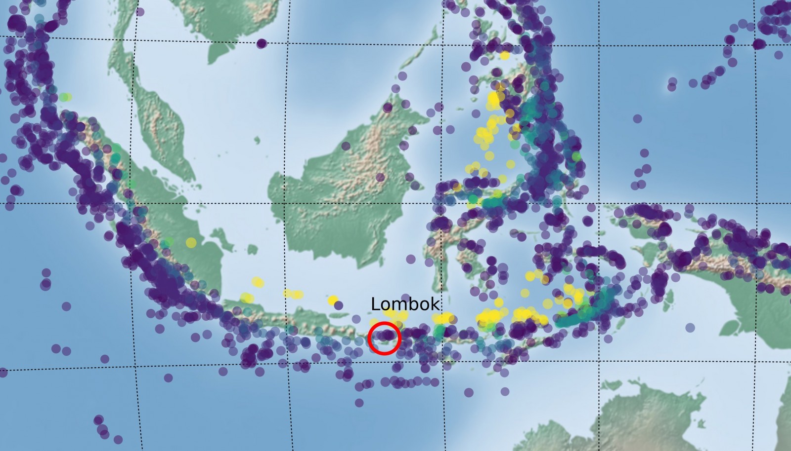
Seismicity in the years 2000-2018 around the Sunda and Banda Arcs, colour coded by depth. The location of Lombok (where the recent series of devastating earthquakes took place) is indicated by the red circle
| Latitude | Longitude | Origin time | depth | Magnitude | Region |
| 8.2597° S | 116.4363° E | 2018-08-05 11:46:38 UTC | 31.0 km | Mww6.9 | Sumbawa Region, Indonesia |
| 8.324° S | 116.6256° E | 2018-08-19 14:56:28 UTC | 25.62 km | Mww6.9 | Sumbawa Region, Indonesia |
| 18.1777° S | 178.1109° W | 2018-08-19 00:19:37 UTC | 563.41 km | mww8.2 | Fiji Islands Region |
Lombok
The quakes in and around the island of Lombok, Indonesia, fall within a larger series of events. Apart from the two Mw 6.9 quakes on 5 and 19 August, there was a whole set of Mw 5+ and Mw 6+ in the surrounding days, not to mention the hundreds of smaller fore- and aftershocks (see Figure 1).
This huge seismic activity around Lombok is hardly surprising: Indonesia lies on the Pacific Ring of Fire, where the Australian oceanic crust subducts beneath the Eurasian plate along the Sunda Arc with a convergence rate of about 7 cm/yr [Nugroho et al, Tectonophysics 2009], consequently generating a lot of seismic and volcanic activity. To the east, subduction has progressed further, such that the Australian continent is now in collision with the Indonesian islands.
The recent quakes are, however, not direct subduction earthquakes – the main subduction zone lies south of the islands and at the location of these earthquakes (between 20km and 30km), the subducted Australian plate sits much deeper. The location and focal mechanism therefore point to a shallow south-dipping thrust fault that is part of the Flores Back-arc Thrust system [1, 2].
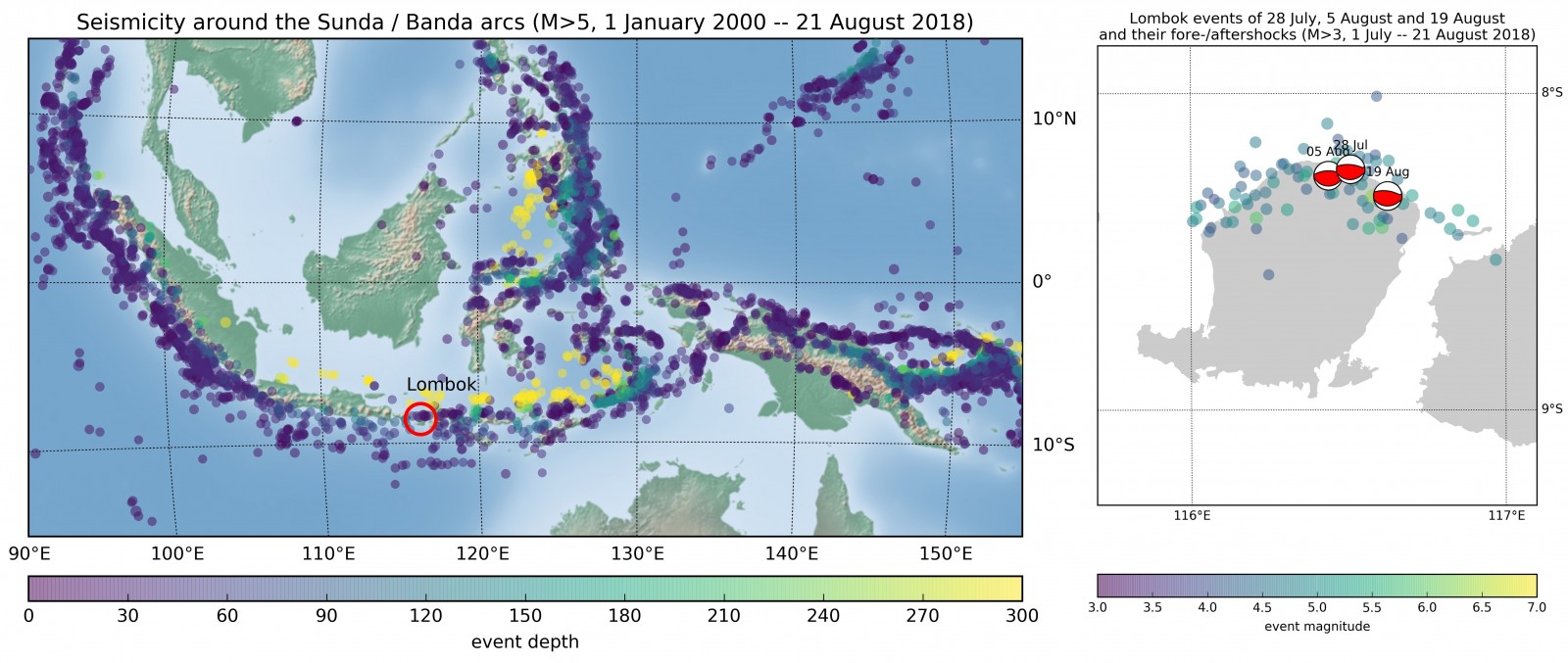
Left: Map of seismicity in the Sunda / Banda arc region. Events were retrieved for the period 2000 to 21 August 2018 from the USGS NEIC catalog, and are colour-coded by depth. Lombok is indicated by a red circle. Right: The three Lombok events discussed in the post, as well as the fore-and aftershocks as recorded between 1 July and 21 August 2018. Fore- and aftershocks are colour coded by event magnitude
The series of earthquakes started with a Mw 6.4 event on 29 July, that killed around 20 people and injured hundreds [3]. About a hundred aftershocks followed, and roughly a week later, on 5 August, an even larger Mw 6.9 event shook the area again, thereby degrading the 29 July event to a foreshock. The Mw 6.9 event was much more destructive with a death toll of more than 450 and counting, not to mention the hundreds of thousands of people who lost their homes, properties and got displaced [4].
A tsunami warning was issued for a while, but was retracted when it became clear no dangerous waves were excited – otherwise the damage might have been even more widespread. Then, two weeks later and just 20 km to the west, another M 6.9 earthquake hit the island on 19 August [5]. Although of the same magnitude as the 5 August event, the 19 August earthquake resulted in far fewer casualties (around ten reported so far [6]) – presumably because of the destruction and evacuation come after the first earthquake.
As anyone living in an earthquake-prone region will tell you, it is common for a whole series of quakes to strike the same area within a short time: the release of stress on one part of a plate contact or system of faults causes another part to become instable, and some argue that this can even happen over very large distances [Stein & Toda, Science 2012]. That’s the reason why, so shortly after this series of destructive events, people on the Lombok island continue to remain on alert, with many preferring to sleep under shelters – even if their homes are still intact.
So what about the M 8.2 event near the Fiji islands?
It also happened on 19 August, was more than 30 times as strong, but barely made it to the news.
Fiji
The 19 August event is a typical deep-focus earthquake and falls within the Tonga subduction zone. At the Tonga Trench, part of the Pacific Ring of Fire, the Pacific plate subducts steeply beneath the Australian plate. The normal faulting focal mechanism, location and depth indicate deformation within the subducted slab (Figure 3).
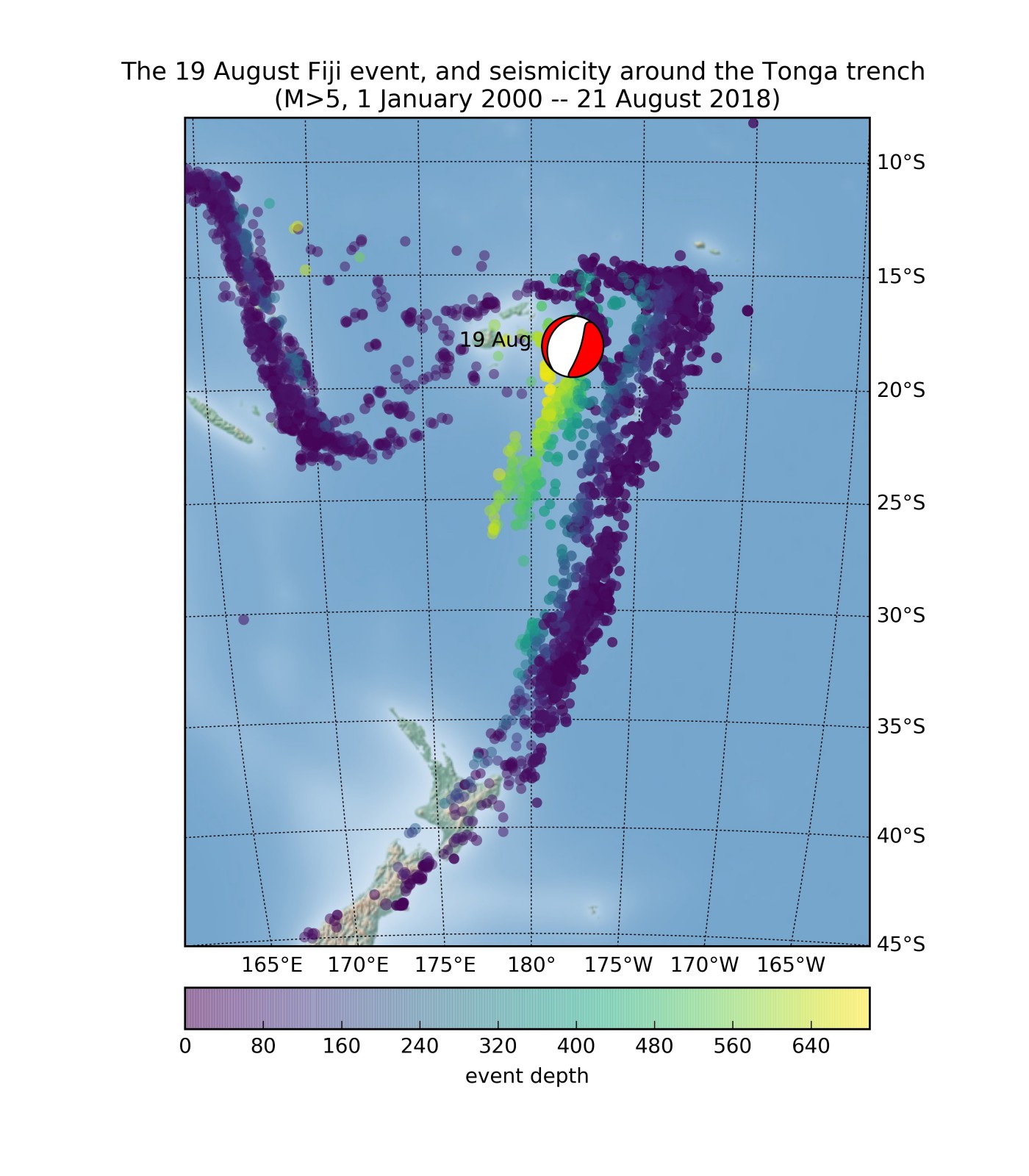
Figure 3: The recent M8.2 earthquake in the Tonga trench region. Background seismicity is all events of magnitudes M>5 as reported by the USGS NEIC catalog.
Both strong events and deep events occur quite regularly along this trench, but what makes the 19 August earthquake quite unique is the fact that it is both strong and deep. However, the USGS has received very few “Did you feel it” reports*: fortunately for the people living on the Pacific islands, its depth of 560 km meant that any devastating surface waves were hardly excited at the surface and damage seems limited so far [8].
On Lombok, on the contrary, the matter cannot be addressed lightly. Efforts have started to clean the rubble and rebuilding houses, schools and hospitals. But this proves to be hard: most of the infrastructure, especially in the north of the island, has been gravely damaged by the earthquakes themselves, or ensuing landslides. Many people are living in temporary shelters, and it is difficult to supply food, clean water, and medicines to the area.
No, the Lombok and Fiji events are not likely to be related, in case someone asks you (although I’m probably preaching to the choir). There are roughly 7000 km between the islands and the only thing they share is a contact with the Australasian plate.
This post was written by Nienke Blom, with revisions from Marina Corradini
[*]: The largest ever recorded deep-focus event was the Mw 8.3 Sea of Okhotsk earthquake, which occurred off the Kamchatka Peninsula on May 24th, 2013 at 600 km depth. This earthquake attracted special attention because, among other issues, it was felt all over Asia [Chebrova et al, J Volc. Seismol. 2015] , despite the large epicentral distance.
Note: data were downloaded from the IRIS and NEIC catalogs using obspyDMT [Hosseini and Sigloch, Solid Earth, 2017] figures were produced using matplotlib based on obspyDMT scripts.
Allam
What is going on with our earth lately. I’m living in Lombok Island. We have quake here almost a month.