By Emma Liu – Lecturer in Earth Science, University College London.
For more adventures, follow Emma on Twitter!
It’s a strange feeling to realise that your closest human neighbours are on the international space station…! We were five hundred miles away from the nearest civilisation and all I could see in every direction was miles and miles of open ocean. There are so few true wilderness environments remaining on Earth that it felt liberating to be somewhere so remote and so untouched by human activity. However, it also meant that our expedition team were well and truly on our own…
In January 2020, I visited the South Sandwich Islands as part of a multi-disciplinary scientific expedition to explore the unique ecology, volcanology, and glaciology of these remote island environments. The South Sandwich Islands are a chain of active volcanoes in the Southern Ocean, located east of the Drake Passage in the region of ocean between South Georgia to the north and the Antarctic continent to the south. The islands themselves are the emergent portions of deep-rooted volcanoes that extend several kilometres beneath the sea to the ocean floor, and many exhibit active expressions of volcanic activity. Together, this chain of volcanoes was formed as the South American tectonic plate was dragged beneath, or subducted, westwards beneath the South Sandwich microplate. This process of subduction continues to this day, generating magmas that rise buoyantly through the thin oceanic crust above to erupt at the surface. The South Sandwich Islands are still evolving, and in 1962 a submarine eruption at the northern end of the volcanic arc began building a new seamount – Protector Shoal – which may eventually grow to become the next island in the arc.
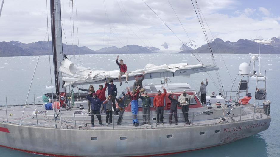
The expedition team aboard the Pelagic Australis. Left to right: Emma Liu, Chris Kobusch, Hamza Yassin, Gemma Clucas, Ted Cheeseman, Jo Feldman, Kieran Wood, Skip Novac, Mario Potocki, Paul Mayewski, Tom Hart, Ruth Peacey, Thomas Geipel, Sophie O’Neill.
My aim on this expedition was to study the volcanic processes taking place along the South Sandwich arc, with a focus on characterising the chemistry of the volcanic gases being released. I set out to collect samples and in situ measurements that would constrain the chemical composition and emission rate of active gas emissions and previously erupted lavas. Together with Dr Kieran Wood (University of Bristol), we made up the volcanological team. Also in the scientific party were Dr Tom Hart (University of Oxford) and Dr Gemma Clucas (Cornell University), who collected aerial imagery and penguin faecal samples to study the ecology and genetics of the vast penguin colonies breeding in the SSI; Prof Paul Mayewski and Dr Mario Potocki (University of Maine), who collected snow and ice core samples from glacial ice to investigate the climatic changes preserved in these records; and Ted Cheeseman, a whale ecologist interested in assessing the recovery of whale populations in the South Sandwich Islands following near-extinction by past whaling activities. We were accompanied by Skip Novac, who has more than thirty years of experience sailing in the Southern Ocean; Jo Feldman, an experienced expedition physician who specialises in decompression medicine; and Ruth Peacey and Hamza Yassin, wildlife film makers who captured every moment of this unique expedition.
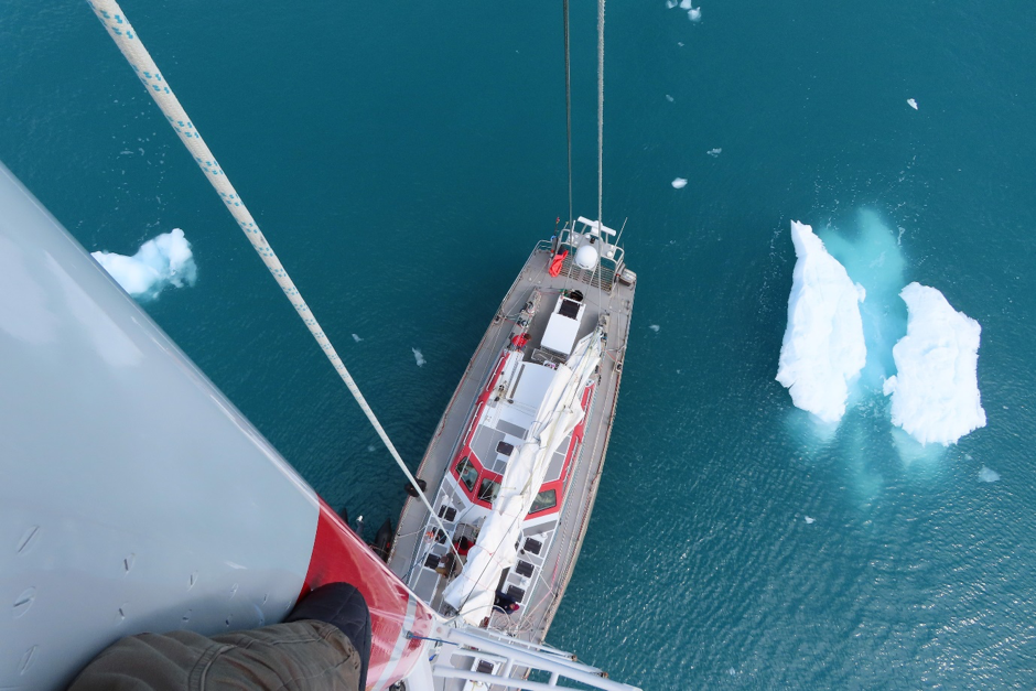
View from the top of the mast (with ropes!) looking down on the deck area.
We set sail from Port Stanley in the Falkland Islands on 30 December 2019 aboard the Pelagic Australis, a 23-metre sailing yacht that would be our home for the next five weeks. The yacht was expertly crewed by Chris Kobusch (skipper), Sophie O’Neill (first mate), and Thomas Geipel (zodiac driver), who had previously sailed around the world as part of the Clipper ocean race. I felt in safe hands. There were no opportunities to restock during the expedition and so the previous day vast supplies of food and water had been loaded on board from the dock and squirreled away in hidden compartments. In the unheated fore peak of the boat, fresh vegetables lasted about three weeks. After that, we relied on tinned and dried foods.
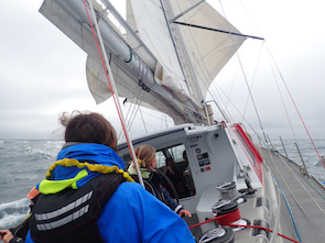
Sailing the yacht was a whole team effort. On watch, we would assist the crew by grinding the winches if the sails needed adjusting.
Before leaving port, we were subject to strict biosecurity checks to ensure we would not be bringing any invasive species – plant or animal – to the islands. Any clothing or equipment that would be going ashore had to be scrubbed and disinfected, and any dirt or seeds caught in Velcro had to be picked out with tweezers. A trained sniffer dog came aboard to make sure that the boat was carrying no unexpected stowaways. We repeated this clothing biosecurity process after every shore landing throughout the expedition. Ahead of us was seven days and nights of continuous sailing to reach our first destination in the South Sandwich Islands. Spirits were high as the harbour faded out of sight; our next sight of land would be Saunders Island.
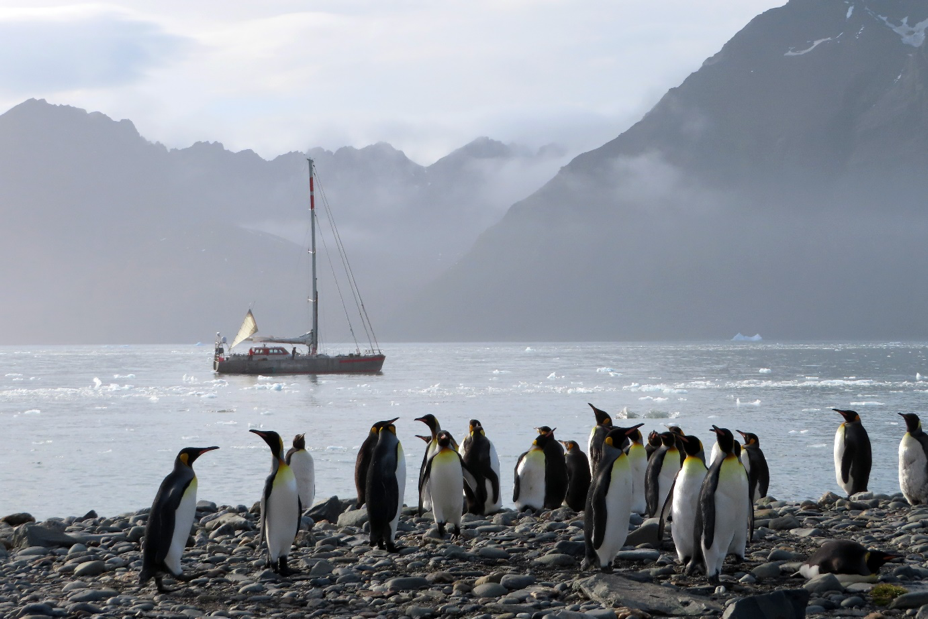
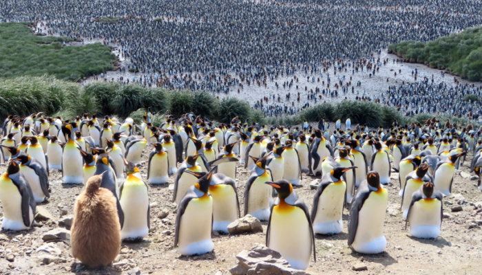
The Pelagic Australis in South Georgia, with a colony of King Penguins in the foreground. This yacht was our home for five weeks during the expedition.
Life aboard the Pelagic Australis quickly settled into a structured routine. We were each assigned to watches, operating on rotation over 24 hours with 3 hours on and 6 hours off. Days and nights blurred into one, with sleep patterns quickly aligning with the watch schedule rather than by the sun. In the early days of the expedition I spent a lot of my time between watches asleep – some days I would sleep 18 hours out of 24 – mainly to keep the sea sickness at bay. I certainly hadn’t developed my sea legs and despite sickness medication I found it easier to lie down and close my eyes than to watch the rolling horizon. It was about five days at sea before the nausea abated, and I began to feel that I could do things like read a book or look at a map. That’s a long time to just stare at the ocean!

Sailing at sunset with beautifully calm seas at Clarke Rocks.
The views from the yacht were spectacular. Miles of open ocean stretched all the way to the horizon in every direction. Albatross, Prions and Snow Petrels dived and fished in the wake of the boat, and Humpback, Fin and Minke whales breached close by. We towed a hydrophone behind the boat to try to capture the sound of the whale’s calls and took as many photos as possible for Ted Cheeseman, who has developed an image analysis algorithm that can identify an individual humpback whale by the markings on its tail fin. During the outward journey, apart from two days of rough rolling seas we had a relatively easy passage with a following wind. When the swell increased, the yacht pitched and rolled in all directions. Sometimes in the night, I would wake suddenly when a large wave caused us to lurch alarmingly to one side. Having never experienced ocean sailing before, I was worried that we were tilting so much we could keep rolling all the way over. I was reassured that it would take an extreme roll of more than 120 degrees to capsize the Pelagic Australis, phew! We sailed most of the way, only relying on engine power when the winds dropped too low for us to maintain 8 knots. With a favourable wind and the full sails unfurled, we were absolutely flying. It was exhilarating.

The zodiac beaches ashore on Saunders Island, and the first task is to rotate the craft to face back into the waves before unloading equipment. Left to right: Jo Feldman, Tom Hart, Thomas Geipel, Gemma Clucas and Ted Cheeseman. Photo credit: Skip Novac.
We reached Saunders Island on the evening of 5 January, anchoring in the eastern bay on the leeward side of the island. Even in the fading light, we could make out spectacular numbers of penguins covering the beach shore and skimming through the water around the boat. It was my first sight of these incredible animals in the wild, and I was amazed by the size of the colony. The noise was immense, a continuous cacophony of penguin screeches. We landed ashore the following morning in the zodiac, a small motorboat that could take 3–4 people plus kit in each trip. We wore full dry suits in anticipation of a wet landing, and all our equipment had to be tightly sealed in dry bags and barrels. It turned out that we were incredibly fortunate with the sea conditions at Saunders, and the zodiac could drive right up to the beach. At the other islands, high surf meant we had to jump overboard and swim ashore, towing our equipment in behind us on a rope line. I soon realised that we needed to streamline the amount of equipment we took ashore each day compared to what we would normally carry into the field. Fast and light became the norm, otherwise we risked not being able to land at all.
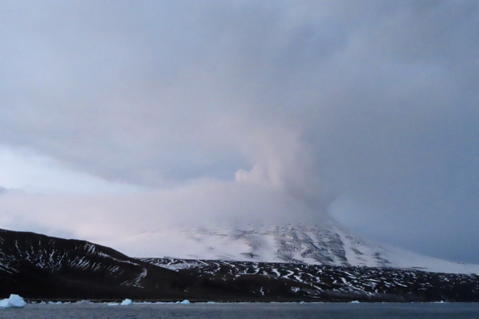
First view of Mt Michael on Saunders Island as we came into anchor. The gas plume can just be seen emanating from the summit behind the clouds.
Mt Michael on Saunders Island was our main target for volcanology. Satellite observations over the past two decades have shown that a persistent gas plume emanates from the summit vent, and that an open lava lake is intermittently visible within the crater. Our ambition was to climb to the summit crater to take direct measurements and samples of the volcanic gases to measure the chemical composition and isotopic signature. We also planned to measure the temperature of the lava lake with a thermal camera, to compare to the temperatures calculated from multispectral satellite images. On the first day ashore, we focused on collecting tephra samples (erupted rock fragments). Hiking up the lower slopes of the volcano and on to the glaciated terrain, we saw that the ground was steaming extensively, a clear sign of geothermal heating from below. We found well preserved tephra exposures in the walls of small crevasses, where you could see well-defined layers of volcanic material separated by ice. Back in the laboratory at UCL, we will measure the chemical composition and mineralogy of the erupted rocks. Combining microscope observations and chemical analyses of the rock samples, we will be able to reconstruct features of the magmatic plumbing system beneath; for example, magma storage depth, initial volatile content, and pressure and temperature of degassing. By sampling sequential tephra layers, we will be able to explore how the chemical behaviour of the volcano, and thus the eruptive style, has changed through time.
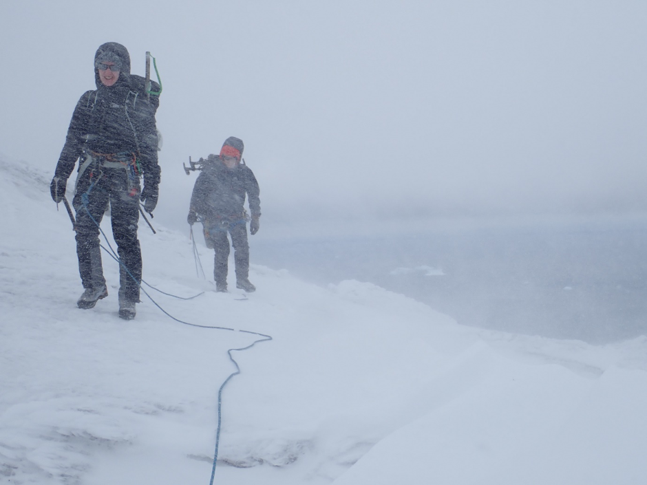
Ascending the southern flank of Mt Michael, we’d roped up for security traversing the crevassed glacier. Conditions deteriorated quickly into a blizzard, however.
We made our summit attempt on the second day. I woke to find the top of the volcano blanketed in a thick layer of cloud and hidden from view, but as the winds were forecast to change direction later in the day I hoped that the cloud would thin out. In any case, it was now or never. We’d assembled a team of five people for the ascent, and we set off shortly after first light. We made good progress and reached the foot of the glacier on the southern flank after a couple of hours. We’d seen from the previous day that the glacier was heavily crevassed, so we roped up for safety. Over the next hour we ascended slowly up to the shoulder of the volcano. There were crevasses everywhere and we’d frequently disappear up to our waist; we were thankful for the security of the rope. The summit still hadn’t cleared, and I was becoming increasingly concerned about the lack of visibility. As we emerged on to the ridge, we felt the full force of the wind. Snow and ice fragments were blown into our faces, the cold biting into our faces. It was a full blizzard, and we took shelter in a snow hole whilst we reassessed the situation. The temperature was falling, and after half an hour the conditions were showing no sign of improving. I knew we had at least another 450 m of ascent to the summit and were facing the prospect of zero visibility from this point forwards. Huddling in our snow hole, we eventually made the decision that we would turn around. I was absolutely torn. I’d lived and breathed this volcano for the past year, dreaming of what we could achieve if we reached the summit. At the same time, I absolutely knew I could not lead my team any further in those conditions. Those first steps in the other direction broke my heart, but ultimately I know we made the right decision.

Sampling an exposed tephra layer preserved glacier ice. This erupted material is likely from the most recent large eruption of Mt Michael in 2016. Pictured: Kieran Wood.
During the rest of our time at Saunders, we achieved as many remote measurements as we could. We set up a UV camera to observe the gas plume and enable us to determine the SO2 emission rate. The UV camera quantifies the amount of SO2 present by analysing absorption of the sun’s radiation. Two cameras acquire images in parallel, each focused at different wavelength (310 nm, at which SO2 absorbs, and 330 nm, in which SO2 does not absorb), and by subtracting the two images it is possible to determine the concentration of SO2. By multiplying the cross-sectional concentration of SO2 with the wind speed at plume altitude, we can derive the emission rate of SO2. We also deployed a miniaturised gas analyser on the flanks of the volcano to intercept the dilute, downwind gas plume. This Multi-GAS instrument measures the concentrations of CO2, SO2, H2S (plus meteorological parameters) in real-time. Lastly, we collected sealed samples of the gas plume in Tedlar foil bags that we will analyse back in the laboratory for its carbon isotope composition, in collaboration with Tobias Fischer and Brendan McCormick Kilbride. I was particularly interested in the CO2/SO2 ratio, which provides valuable information about carbon supply through the South Sandwich subduction zone, especially in combination with carbon isotope measurements. This ratio can also be combined with the independent measurements of SO2 emission rate from the UV camera to derive the volcanic flux of CO2 to the atmosphere.
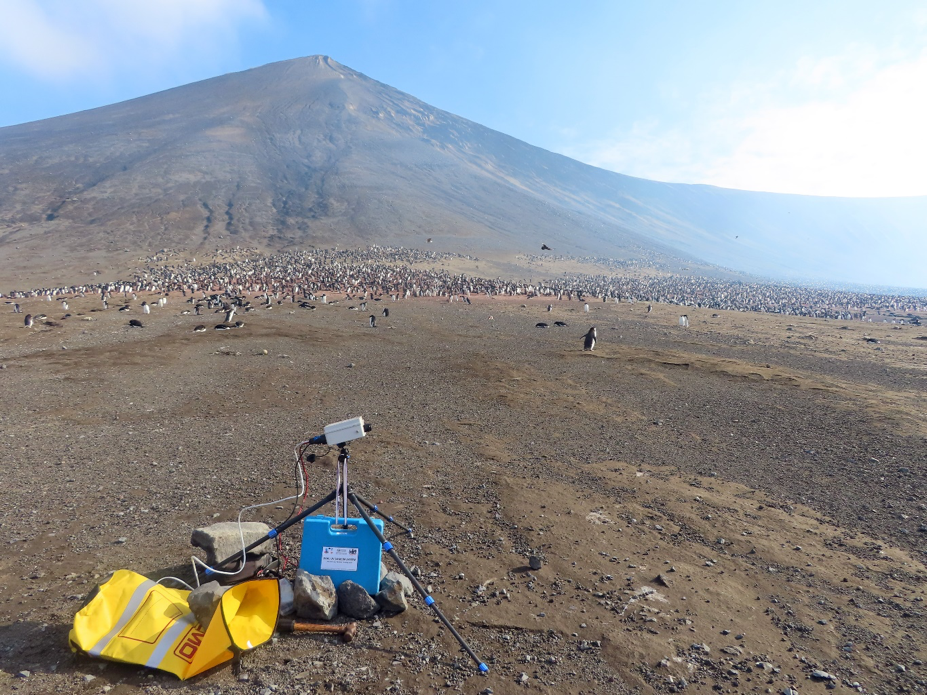
A UV camera station (with thanks to Sandro Aiuppa, University of Palermo) set up on Saunders Island. This instrument views the gas plume remotely and determines the concentration of SO2 by wavelength-specific light absorption.
Over the next nine days, we made further landings in the South Sandwich Islands at Bellingshausen, Thule, and Candlemas. At each island, we sampled the chemistry of the volcanic gases and collected rock samples wherever possible. We also acquired aerial imagery for the construction of photogrammetric digital elevation models. This part of the project was led by Tom Hart, who will also use the aerial imagery to make a detailed census of the size and habitat selection of the penguin populations.
Working amongst such incredible wildlife was an absolute privilege. The South Sandwich Islands are home to some of the largest penguin colonies on Earth. These colonies live together with many species of seals (fur seals, weddell seals, elephant seals and leopard seals) and sea birds (giant petrels, snow petrels and skewers). In the complete absence of human activity, these beautiful animals can live free from any external stresses. We kept a respectful distance from any wildlife, but if they chose to approach you it was a joy to sit still and quietly watch their curiosity. A key multi-disciplinary aspect of this expedition has been to explore the impact of volcanic activity on the ecology of these remote islands. In particular, we wanted to understand the effect of recent eruptions on the population numbers of breeding penguins. Our preliminary observations before any detailed genetic analyses suggest that these colonies appear to be stable and, in fact, thriving.
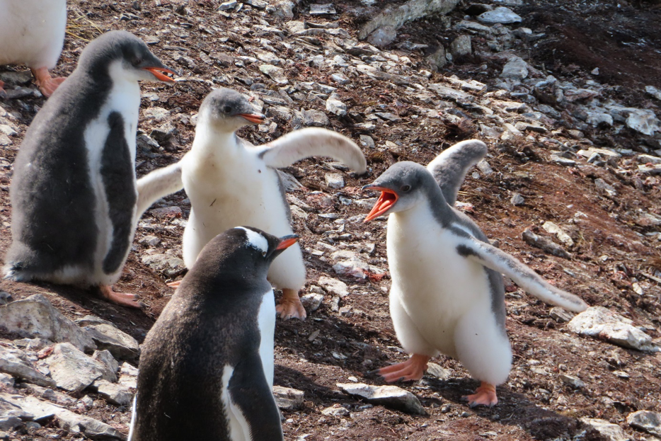
Gentoo penguin chicks finding their voice.
This expedition challenged me in every way. It was an intense five weeks aboard the Pelagic Australis and a truly once-in-a-lifetime experience. The South Sandwich Islands are harsh, inhospitable environments and the oceans around them are exposed and unforgiving. Every minute that we were able to be ashore was a privilege, and every observation and measurement was hard won. Few volcanologists have ever visited these Islands, and fewer still have landed ashore. We have joined a small handful of people who have had the opportunity to study these remote and enigmatic volcanoes up close, and I’ve come away with a renewed appreciation of why that is. Before I left for this expedition, I was warned that we were at the mercy of the weather and should expect to achieve about 10% of what we had planned. With this in mind, I can confidently call the expedition a huge success. We made six shore landings on four islands, collected aerial imagery that will enable the generation of new topographic models, collected almost 40 kg of lava and ash samples, and acquired gas measurements and bag samples from three actively degassing volcanic islands. On top of this, the other scientific teams had their own success stories. I may not have achieved everything I set out to do on this expedition, but all the observations we made will contribute to furthering our growing understanding of volcanism in this unexplored region. I’m determined that this will not be the last time I venture to the South Sandwich Islands, as there is so much left to learn about this unique volcanic environment.
Y Ew
Interesting
Madison Ting
I agree