Agung volcano, a 3.1 km high cone located in the east of Bali, Indonesia, which last erupted in 1963 killing ~1500 people (Self and Rampino, 2012), is currently undergoing seismic unrest, and steam/gas emissions have been observed at the surface. This has led the Indonesian authorities to evacuate areas around Agung which could be affected by volcanic hazards, leading to the displacement of over 75,000 people.
The most likely cause of this unrest is the injection of hot, fluid magma called basalt into a cooler more viscous magma called andesite, as proposed by Self and Rampino (2012) to explain the onset of the 1963 eruption. When the basalt interacts with the cooler andesite it leads to a series of dynamical processes that release volatiles (primarily H2O, SO2 and CO2) at the surface and pressurize the magma plumbing system, resulting in strain producing seismic energy release.
Whether this leads to eruption or not depends on whether the pressure in the magma chamber can exceed the confining pressure, and produce a magma ascent to the surface. No one knows if this will happen in the next few days, but it easily could, and sooner or later there will be an eruption. The decision by the Indonesian authorities to evacuate was clearly sensible, and it appears that the local populations have been well informed on the dangers posed by Agung, helped by the living memory of the events in 1963/64. However, the normal pattern of events leading to eruption is often an exponential increasing seismic energy release, and the most recent data appear to suggest that after an initial acceleration in seismicity the system is now is a quasi-steady state, which could change very rapidly. In some ways, the best course of events would be the for the eruption to begin soon, while the alert is at maximum level and most people in potential danger have been evacuated. If there is now a pause of days/weeks without activity, there will be a growing pressure by local populations to reoccupy evacuated zones, increasing the vulnerability in case of a sudden eruption onset. Such challenges are, sadly, a fact of life for people world-wide living in the shadow of active volcanoes, and while our research makes progress in understanding the processes driving volcanic activity, we are still far from being able to provide deterministic forecasts of future eruptions.

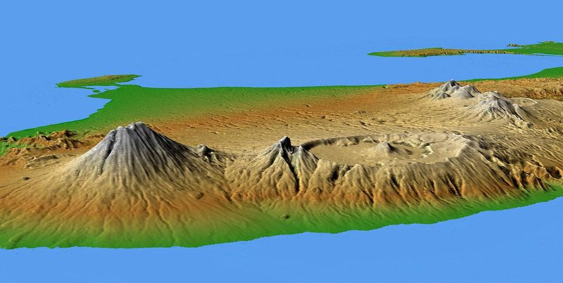
Digital elevation model showing the major volcanic group of Bali. The conical mountain to the left is Agung which underwent a major eruption in 1963 and is currently showing signs of unrest. In the center is the complex structure of Batur volcano, showing a caldera (volcanic crater) left over from a massive catastrophic eruption about 30,000 years ago. Credit: NASA
The main hazards posed by Agung are pyroclastic flows and lahars. Pyroclastic flows have two main causes. The first cause of pyroclastic flows is the collapse of lava accumulating in the summit area, which produces a hot rock avalanche, entraining cooler air and accelerating as it flows down the flanks of the volcano. These flows can extend for several km from the summit. The second source of pyroclastic flows is eruption column collapse, when a volcanic explosion erupts a large volume of rock into the atmosphere, which then falls back down around the summit area, producing hot rock avalanches again, but this time with greater energy. This was the dominant source of pyroclastic flows in the last, 1963 eruption of Agung, producing flows to ~10 km distance from the summit, primarily to the NNE, but also to the SSW and SE. The total volume of lava and tephra (fragmented rocks in the eruption column) erupted during the 1963 eruption was ~1 km3, over a period of just under a year (Self and Rampino, 2012). Lahars are flows of mud and volcanic ash, which can be easily mobilised when freshly deposited ash is carried by the intense rains in the Indonesian rainy season. The most intense rains usually occur between November to March, so an eruption in the coming weeks could lead to lahars quite quickly. These mud flows are extremely hazardous as they can flow quickly and for long distances, scouring the land and damaging infrastructure, as well as posing a threat to life.
The probability of a large number deaths and injuries is much lower now than it was in 1963, as modern volcano monitoring techniques have improved, there is much better awareness of the hazards posed by explosive eruptions and, most importantly, local populations are better informed, with clearer communication links. About 25% of eruptions from Agung are of slightly larger magnitude (Fontijn et al., 2015), with the last eruption before 1963 occurring in 1843, producing eruption deposits approximately twice that of 1963. There have been three other, similar magnitude eruptions over the last 5000 years, but no indication of anything significantly larger. There are numerous smaller eruptions observed in the stratigraphic record. Therefore, planning for a scenario similar to the 1963 eruption with pyroclastic flow run out up to 12 km from the summit is prudent, with a good probability that the actual eruption will be smaller than that.

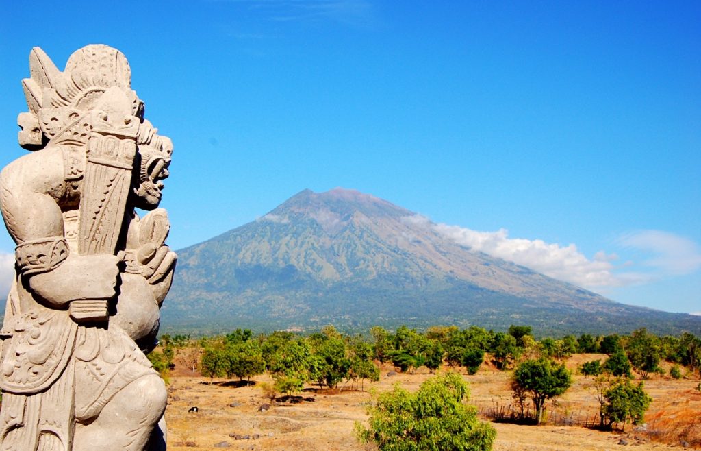
The north-east flank of Agung Volcano seen in 2009. Credit: Antoine Vasse Nicolas.
Apart from the local impact, an explosive eruption from Agung could affect air traffic through the dispersal of ash into the atmosphere, and climate, through the injection of SO2 and HCl into the stratosphere. The numerous active volcanoes in Indonesia produce explosive eruption that quite frequently disrupt air traffic, with the most recent events including the closure of Lombok’s Praya Airport in August 2016 due to the eruption of Rinjani volcano. The eruption of Raung in July 2015 led to the closure of airspace over Java, Sinabung in 2014/2015 affected Sumatra and Kelut effected aviation in Java in 2014. The danger posed by ash to aircraft is that the ash melts within the jet engine, and then accumulates and solidifies on a cooler rotor, eventually blocking the engine entirely. This occurred in June 1982 on a British Airways flight from Malaysia to Australia, which flew through the eruption cloud from Galunggung volcano, Java, resulting in engine failure of all four engines of the 747 jet. After numerous attempts the pilot was able to restart the engines, and the plane landed safely.
The injection of SO2 high into the atmosphere can produce climatic impacts through the generation of sulphuric acid aerosol droplets which reflect solar radiation, cooling the surface of our planet. The 1991 eruption of Mt Pinatubo in the Philippines is the most well-known example of this, producing a global cooling of 0.5 C after erupting ~18 Mt SO2 (Guo et al., 2004). The 1963 eruption of Agung erupted ~7 Mt of SO2 into the stratosphere (Self and King, 1996), and would have slightly affected climate. Stratospheric injection of HCl can produce ozone depletion, but the humid conditions of Indonesia means that the bulk of erupted HCl will be rained out.
In conclusion, the current unrest on Agung may well lead to an eruption, and it will be closely monitored by the Indonesian authorities, who have already taken preventative action by evacuating local populations. This unrest is being followed attentively by many people on twitter and other internet sources, with continuous live updates, so any change in activity will be known worldwide within minutes.
In parallel with the activity at Agung, there is also an evacuation of 11,000 people from Ambae island, Vanuatu, due to the threat posed by an eruption from Manaro Voui volcano. This important event will be the subject of a future blog post by the GMPV Science team.
Blog written by Mike Burton, GMPV President (gmpv@egu.eu), with comments from Olivier Bachmann, (Scientific Officer of the GMPV Division).
