by Emma Lodes, PhD student, GFZ-Potsdam (Germany)
Twitter: @LodesEmma | email: lodes@gfz-potsdam.de
Research in Earth Science starts with the spark of an idea, and is then often challenged by issues with access, temporal or spatial scaling, lack of knowledge in specific domains, or simply road bumps in our lives. As Early Career Scientists (ECS), and especially as students, our individual projects can isolate us, leaving us feeling as if no one shares our struggles or has the same questions. In reality, however, our problems are shared with our peers across fields in the earth sciences, and our peers are often even willing to help us out!
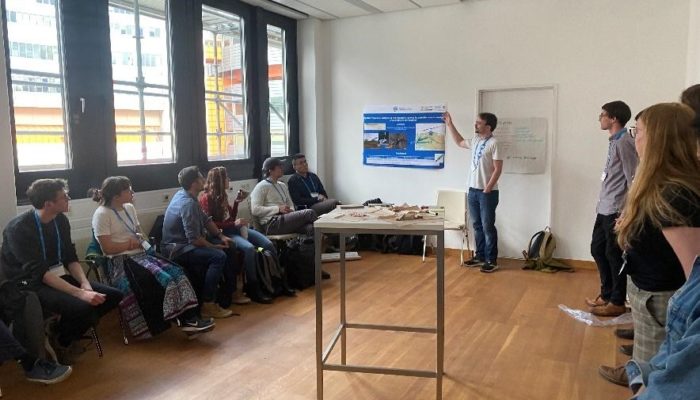
This year’s crowd solving session at EGU – “Crowd solutions to challenges in Earth Sciences” — started with an unexpected problem and a crowd-solved solution. The networking room we booked was occupied, and in fact had been double-booked. After some exchange with the occupying party, we went on a hunt for a new space, and as a group, populated a smaller room with our posters and chairs, while spontaneous volunteers posted signs to point potential problem-solving passerby’s in the right direction. With teamwork, an unintentional warmup exercise led to a lively yet intimate session with around 20 participants.
Most importantly, this year’s crowd solving session allowed us, yet again, to communicate across disciplines and see that we are not alone. We tackled four diverse problems that spanned the subjects of field work, coding and modelling, and remote sensing. Four ECS presented their problems, and the participants divided into groups, each of which discussed possible solutions to a presented problem. To wrap it up, each group presented the solutions to all participants, and a broader discussion ensued. The discussions continued at a gastropub in Vienna, where we convened with other ECS in the EGU Geomorphology Division. The result was a relaxed and spirited evening in celebration of communication and togetherness in a “post-covid” time. We received positive feedback; participants found it easier than expected to contribute to problem solving in a different field, and that their challenges were more common than they previously thought. Overall, we felt quite inspired, and ideas for next year’s session have already emerged. Some are related to our EGU experience, such as: How do I get the most out of EGU, and how can we as ECS influence sessions?
But for now, here are the problems we discussed this year:
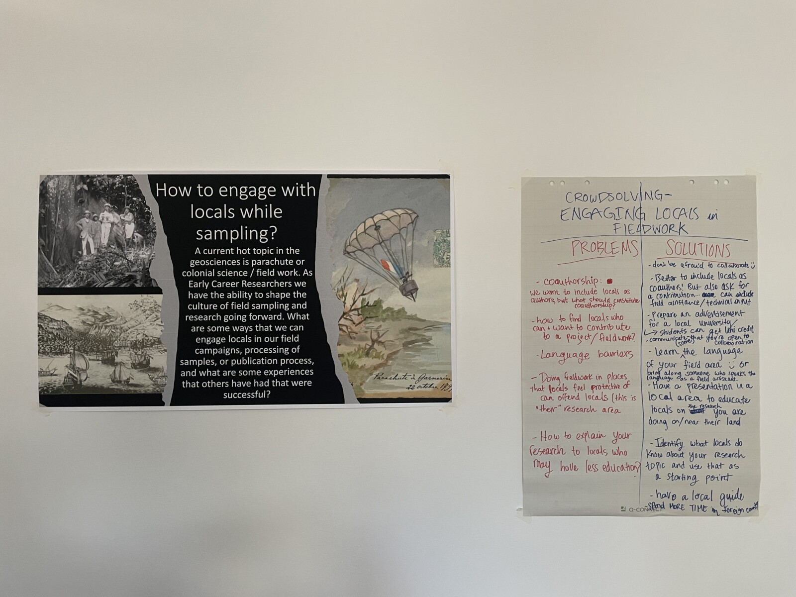
How can we better engage with locals in the field? – Emma Lodes, GFZ-Potsdam, Germany
A current hot topic in science is “parachute” or “colonial” science in field work. As ECS, we have the ability to shape the culture of field sampling and research going forward. So, what are some ways that we can better engage local people in our field campaigns, processing of samples, or publication process? For example, how can we find local people who can and want to contribute to a project or field work, and how can we breach a potential language barrier? Projects with field sites abroad should ideally include local researchers as coauthors. But then what should constitute coauthorship? Also, local people should receive information on the research conducted on their land or in their region. But how can we best communicate our science in a way that can be understood? Our group came up with many potential solutions. First, to recruit local collaborators, we can advertise at a local university and suggest that students receive university credit for helping. Don’t be afraid to collaborate and communicate that you are open to collaboration! In an ideal case, we should take the time to learn the local language, and if this is not possible, we should bring along a field assistant who speaks the local language or find a local guide. We should try to include local people as coauthors, but coauthorship should be dependent on a contribution, such as (at least) field or technical assistance. Finally, we should all attempt to present our research for local populations to explain what we are doing on their land, and especially if the results have implications for the local environment. Identify what local people know about your research and use that as a starting point.
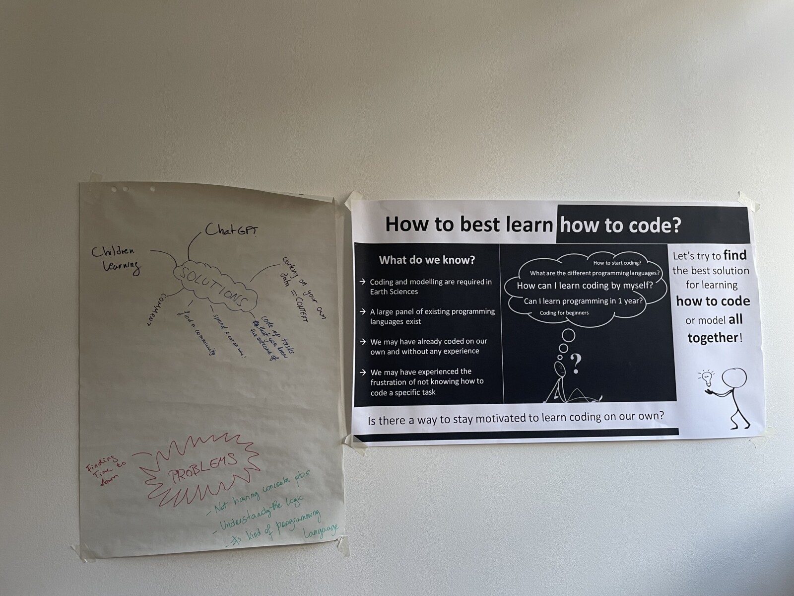
Help! How can I quickly learn how to code? – Kapiolani Teagai, IFP Energies Nouvelles, France
Coding and modeling are increasingly important skills in the earth sciences, and graduate students and postdocs are increasingly expected to incorporate some form of modelling into their projects. In addition, learning how to code can be useful for those looking for careers outside of academia. But how do we stay motivated to learn on our own, and where should we start? Coding and modelling courses exist, but some say it is best to learn to code through experience. For those beginning to learn, which coding languages or platforms are the most useful for the earth sciences? One major roadblock to learning how to code is the time it takes; students don’t always have the extra time in their contracts to learn. It can also be difficult to learn how to code without concrete problems to solve, and understanding the logic of coding can be a leap without prior experience. To solve these problems, we must find the time to learn, or ask for the time. Learning materials for children can be useful for adult beginners too, and Chat GPT can be useful for understanding or translating code. It is crucial to comment your code, so you remember what to do next time. Working on your own data gives you the context you need to understand the task, and try to code up tasks that you know the outcome of. Finally, find a community of learners for support!
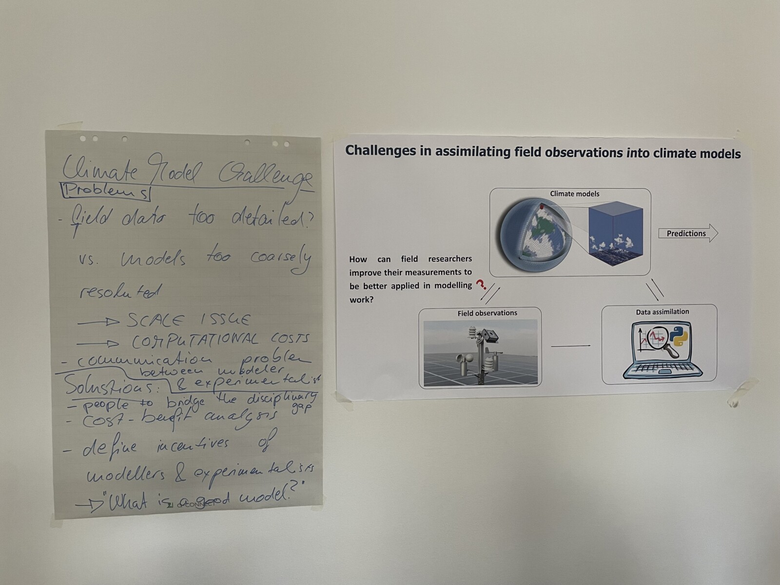
Data (in)compatibility: Mismatches between field data and climate models – Guangyu Li, ETH Zürich, Switzerland
Too often, there is a lack of communication between field scientists or experimentalists and modelers, where field measurements are designed in a way that does not take the needs of climate models into account. This may lead to field data that is incompatible with the format and resolution required by climate models. The scales of the observations and models can differ; for example, field data can be too detailed, while models are too coarsely resolved. This scale issue is often caused by the computational costs of running the model and leads to communication problems between modeler and experimentalist. To solve this issue, we need people to bridge the disciplinary gap. It is also useful to make a cost-benefit analysis, and to define the incentives of modelers and experimentalists. Finally, we must consider: What is a good model, and what must I do to achieve this?
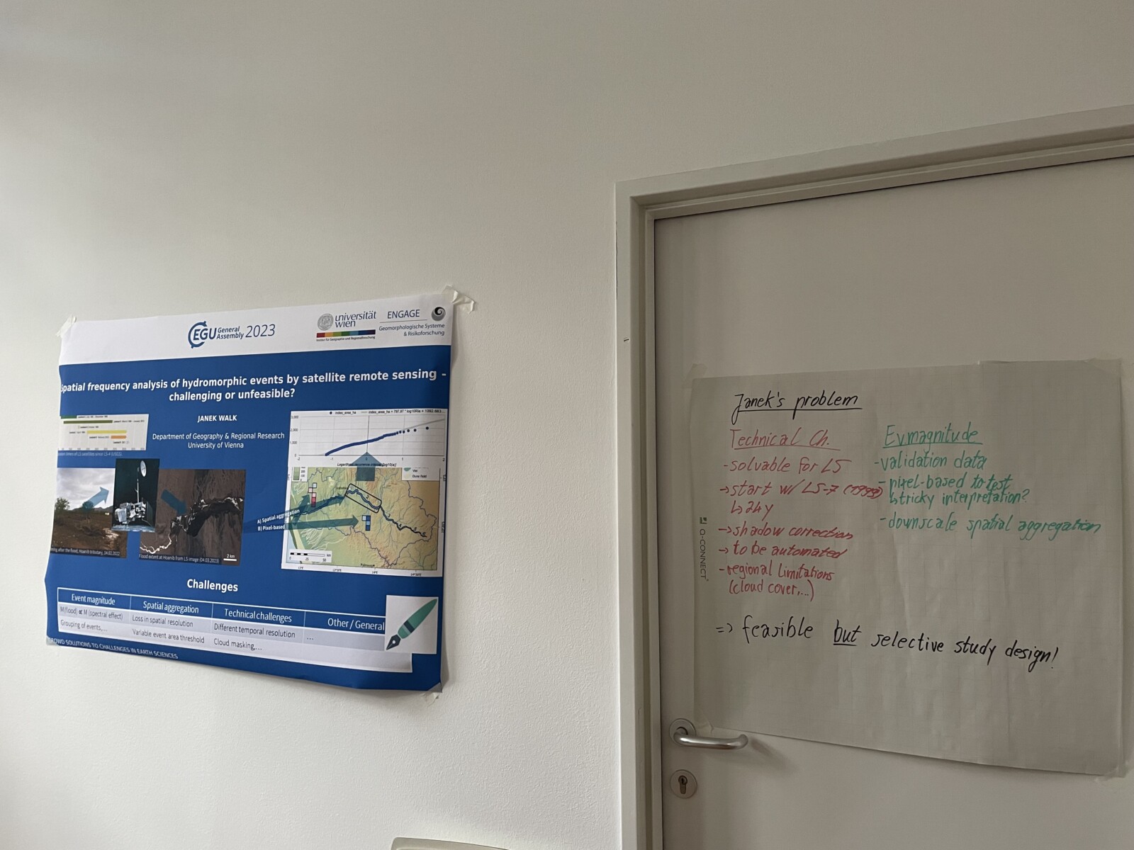
Is a spatial flood frequency analysis using satellite remote sensing (un)feasible? – Janek Walk, University of Vienna, Austria
Satellite imagery is immensely useful in Earth Science, yet technical challenges remain that can prevent us from exploiting its full potential. For example, hydrological events can be difficult to resolve spatially and temporally. How can we derive the magnitudes of hydromorphic events, such as floods, and their respective frequencies? Specifically, how can we extract this information from long time series of satellite imagery for spatial aggregates of areas of interest, such as floodplain segments, and, ultimately, on a pixel scale? The magnitude of a flooding event can be difficult to decipher as a proportionality between the event and the spectral effect magnitudes is doubtful, especially due to the complex hydrogeomorphic feedbacks of a succession of events. In contrast to a pixel-based approach, spatial aggregation is concomitant with a loss in spatial resolution and further requires setting variable event area thresholds. Moreover, technical challenges include different temporal baselines, shadow effects, and cloud masking. Consequently, is this methodology unfeasible or just challenging? Thankfully, the group came up with some solutions. To assess how the event magnitude scales with the spectral effect, we can use hydrological validation data. As one cannot expect a spatially consistent effect on pixel scale, a refined spatial aggregation approach might be the best solution. Moreover, most technical challenges are easily solvable when using the Landsat archive starting in 1999. While shadow correction and cloud masking can be conducted automatically, the latter might still entail regional limitations. In the end, the group concluded that resolving hydromorphic events from satellite data is feasible by creating a selective study design.
If our crowd solving event sounds interesting and you would like to get involved with next year’s crowd solving session, either by contributing a problem or helping as a convener, please contact Emma Lodes (lodes@gfz-potsdam.de)!
![20 Years of GM [Part 1]: Looking Back with Geomorphology Division Presidents!](https://blogs.egu.eu/divisions/gm/files/2025/04/4-161x141.png)