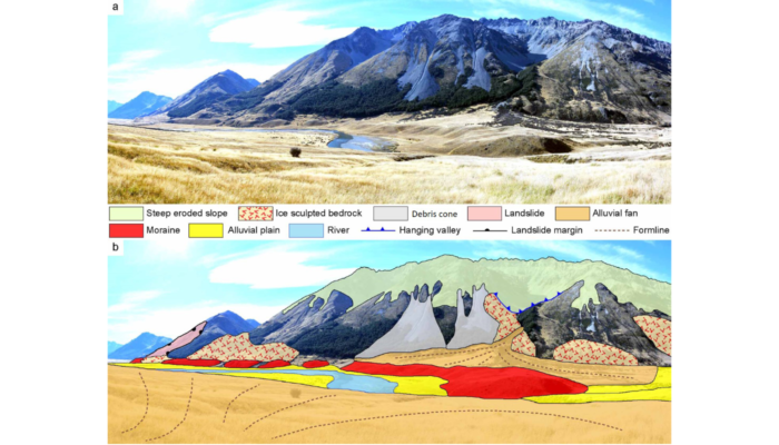
Glacial geomorphological mapping comparison in 3D. a – Moraine ridge in the middle section of the Ahuriri River valley with surrounding area. b – Key landscape elements are shown in the accompanying sketch. (Credit: Tielidze et al., 2021).
Geomorphological maps are a fundamental tool to represent landforms and understand how different morphological elements and agents shaped a natural landscape. They are also important as background information for many fields of research including ecology, forestry and of course, glaciology. In this week’s blog, Levan Tielidze tells us about the importance of mapping glacial geomorphology, presenting a new map from New Zealand.
This is a joint post, published together with the cryospheric sciences division blog and the geomorphology division blog, given the interdisciplinarity of the topic.
– written by Levan Tielidze, Victoria University of Wellington –
Purpose of glacial geomorphological mapping
Geomorphology is the science that studies, describes, and explains landforms on the Earth’s surface. Geomorphological mapping is a major part of this science as it accurately represents the landforms of a particular area and indicates the past and present-day processes that shape that landscape. Glaciologists interested in studying past and modern glaciations rely on geomorphological mapping. Detailed geomorphological mapping of ice-related and post-glacial landforms is widely used to describe and understand past glacial fluctuations and dynamics.
The landscapes of New Zealand is defined by a full spectre of geomorphological sights, such as fiords, narrow and deep gorges, coastal lowlands, volcanic cones and active volcanoes, caves and tectonic folds and of course glaciers and high glacial mountains. The latter represent one of the major tourist attraction of New Zealand and also an important source of fresh water.
In New Zealand geomorphological maps are available for the major valleys which were shaped by glaciers (e.g. Tekapo, Pukaki, Ōhau) in the central Southern Alps of New Zealand (Barrel et al., 2011) but very little was known until recently about the Ahuriri River valley (Waitaki River basin) (Figure 2), that was also sculptured by former glaciers during the Last Glacial Maximum. Recently, the first detailed glacial geomorphological description and map (1:38 000 scale) of the assemblage that was conditioned by the former Ahuriri Glacier, Southern Alps, New Zealand (44°15’S, 169°36’E), were presented.
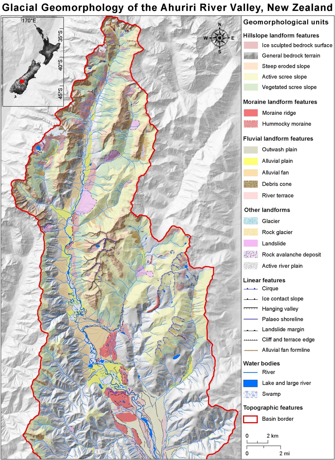
Glacial geomorphological map of the Ahuriri River valley. Downsized version (Credit: Tielidze et al., 2021).
Mapping and compilation method
The glacial geomorphology of the area surrounding the Ahuriri River valley was mapped using a combination of remote sensing analysis and field work. The geomorphological mapping was conducted by visually interpreting high-resolution (40 cm) aerial imagery and NZ topographical maps. Images from Google Earth were also used for the mapping in areas where three-dimensional (3D) landscape recognition was required (e.g. for better interpretation of remote areas). Field campaigns in April 2019 and February 2020 allowed us to crosscheck features mapped from remote imagery and maps. We did not cover the entire ∼532 km2 study area on the ground due to its remote and challenging nature, however we accessed the major landform features by 4 × 4 vehicle and general hiking tracks in the main river valley.
An example of glacial geomorphological mapping, Canyon Creek valley (Ahuriri River basin), New Zealand (Credit: L. Tielidze)
Overall, this new map presents a variety of glacial-related landform assemblages. These include modern glaciers, rock glaciers (see this previous blog post on rock glaciers), cirques (or corries), ice-scoured bedrocks, ice-contact slopes, moraines (moraine ridges and hummocky moraines), outwash plains, and alluvial fans (Figure 3-4). Well, if you are not very confident with geomorphology, you just need to know that all these forms are produced by the erosion and sedimentation created by the movement of glaciers.
The Main Map (Figure 2) also includes non-glacial landform types (e.g. steep eroded slopes, active scree slopes, vegetated scree slopes, debris cones, river terraces, active river plains, alluvial plains, etc.) and topographic features (e.g. rivers, lakes, peaks, fault lines, etc.), which are useful to constrain the topographic and geographic context.
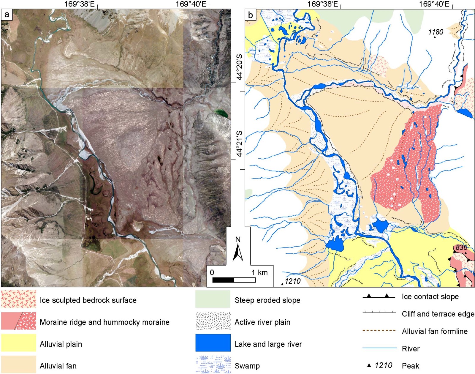
a – High-resolution (40 cm) aerial image showing the largest alluvial fan and surrounding area in the lower section of the Ahuriri River valley. b – Digitised example of geomorphological mapping conducted for the same place. (Credit: Tielidze et al., 2021).
A map of the past
Based on detailed glacial geomorphological mapping, we know that the distribution of post-glacial landforms in the middle and lower section of the Ahuriri River valley outlines at least three advances or stillstand phases of past glaciers and suggests a maximum length of ~41 km for the former glacier during the Last Glacial Maximum (approximately 20,000 years ago). Most of the tributary valleys were also probably covered by ice at this time. Other prominent but smaller size moraines, mostly in the tributary river valleys, point to minor post-glacial advance phases of former glaciers. This map provides an essential basis for constructing reliable geomorphological and geochronological reconstructions in the Southern Alps of New Zealand. More detailed geomorphological mapping from New Zealand region will help to better understand past glacier-climate interactions in the Southern Hemisphere.
Next time you’re walking amongst the hills and valleys, stop and think about which post-glacial landforms might be right below your feet!
References
Barrell, D. J. A., Andersen, B. G., Denton, G. H. (2011). Glacial geomorphology of the central South Island, New Zealand. GNS Science monograph 27. 81 p. + map (5 sheets) + legend (1 sheet). Lower Hutt, New Zealand, GNS Science.
Tielidze L. G., Eaves S. R., Norton, K. P., and Mackintosh A. N. (2021). Glacial geomorphology of the Ahuriri River valley, central Southern Alps, New Zealand, Journal of Maps, 17:2, 73-86, doi: 10.1080/17445647.2021.1876777.
Author Information

Levan Tielidze is a PhD student at Antarctic Research Centre and School of Geography, Environmental and Earth Sciences, Victoria University of Wellington. His field of research is modern glaciers and glacial-geomorphological studies of mountainous regions in the Late Quaternary. Contact email: tielidzelevan@gmail.com
Twitter @LevanTielidze