If you are an Early Career Researcher or looking for a new research opportunity why not check out the EGU job site!?
Drilling into magma: the future of electricity production from volcanic geothermal systems?
Words on Wednesday aims at promoting interesting/fun/exciting publications on topics related to Energy, Resources and the Environment. If you would like to be featured on WoW, please send us a link of the paper, or your own post, ERE.Matters@gmail.com
***
Blog by Samuel Scott
Electricity production from high-enthalpy geothermal systems typically involves drilling boreholes into permeable reservoirs at depths of 1-2 km and temperatures between 250-300 °C. The fluid that comes up the wellbore consists of a mixture of liquid and vapor, from which the vapor is separated and passed through a steam turbine to generate on average 3-5 MW per well. The Iceland Deep Drilling Project (IDDP) was founded by a group of international scientists who sought to drill to deeper, hotter conditions where water is a single-phase, intermediate density, supercritical fluid. Basic thermodynamic considerations suggest that wells drilled into supercritical geothermal resources could potentially provide an order of magnitude more electricity than a conventional geothermal well. A plan was developed to drill a borehole to 4-5 km depth in the Krafla geothermal system, with the aim of discovering a reservoir at supercritical temperatures (>374 °C) and pressures (>220 bars).

Transparent, opalescent steam discharges from the IDDP-1 borehole at the Krafla volcano in Iceland. (Image: Kristján Einarsson/IDDP)
Drilling was difficult and did not go as expected. After chunks of quenched glass began to come up the wellbore, they knew that they had drilled into a magmatic intrusion located around 2 km depth. Studies of the glass showed that it was rhyolitic in composition. Temperature measurements suggested a fluid temperature as high as 450 °C, but since the intrusion was encountered at a relatively shallow depth, the fluid pressure was less than the supercritical pressure, and the fluid was categorized as ‘superheated steam’. The big surprise was the fact that the fluid reservoir was nonetheless much more powerful than typical wells drilled to 2 km depth. As can be seen in videos taken during the well testing (https://vimeo.com/28453850), the well discharged large volumes of translucent and opalescent fluid – classic indicators of a supercritical fluid. Well tests indicated that the well could potentially generate 35 MWe of electric power, roughly an order of magnitude greater than a typical geothermal well. However, there were many questions that surrounded this discovery. How did this fluid reservoir form? How could it form at such a shallow depth? It was unclear whether the IDDP reservoir was an anomaly, or whether similar resources could exist in other high-enthalpy systems.
This led myself and a group of collaborators at ETH Zurich to use numerical models to understand the hydrology of the IDDP reservoir. The computer![]() code had already been successfully applied to understand high-temperature fluid flow in other settings, such as mid-ocean ridges and the formation of copper-rich porphyry deposits. We set-up the model such that only a few key parameters were needed, aimed at capturing the main sources of geologic variability between different geothermal settings. The key data that go into the model are the depth of the intrusion, the host rock permeability (a measure of how fractured the system is as a result of tectonic activity) and the brittle-ductile transition temperature (which determines the temperature where rock becomes impermeable due to plastic deformation closing connecting fluid flow pathways).
code had already been successfully applied to understand high-temperature fluid flow in other settings, such as mid-ocean ridges and the formation of copper-rich porphyry deposits. We set-up the model such that only a few key parameters were needed, aimed at capturing the main sources of geologic variability between different geothermal settings. The key data that go into the model are the depth of the intrusion, the host rock permeability (a measure of how fractured the system is as a result of tectonic activity) and the brittle-ductile transition temperature (which determines the temperature where rock becomes impermeable due to plastic deformation closing connecting fluid flow pathways).
These models show how these primary geologic controls determine the extent and thermal conditions of supercritical reservoirs. For example, our study identified a brittle-ductile transition temperature greater than 450 °C as a key control on reservoir formation. Since basalt has a brittle-ductile transition temperature >450 °C, while granite becomes impermeable around 360 °C, we expect that the best resources will be found in basaltic rocks. Additionally, if the rock surrounding the intrusion is very permeable, we expect the supercritical resources to be close to the intrusion, relatively limited in spatial extent, and at temperatures near 400 °C. If the rock surrounding the intrusion is moderately permeable, the reservoirs will be larger and at higher temperatures. However, the fluid production rate for a well drilled into a supercritical reservoir will be higher when rock permeability is higher. Thus, there is a trade-off between fluid temperature and well productivity that is governed primarily by rock permeability. These basic concepts can inform future efforts to discover and exploit these resources.
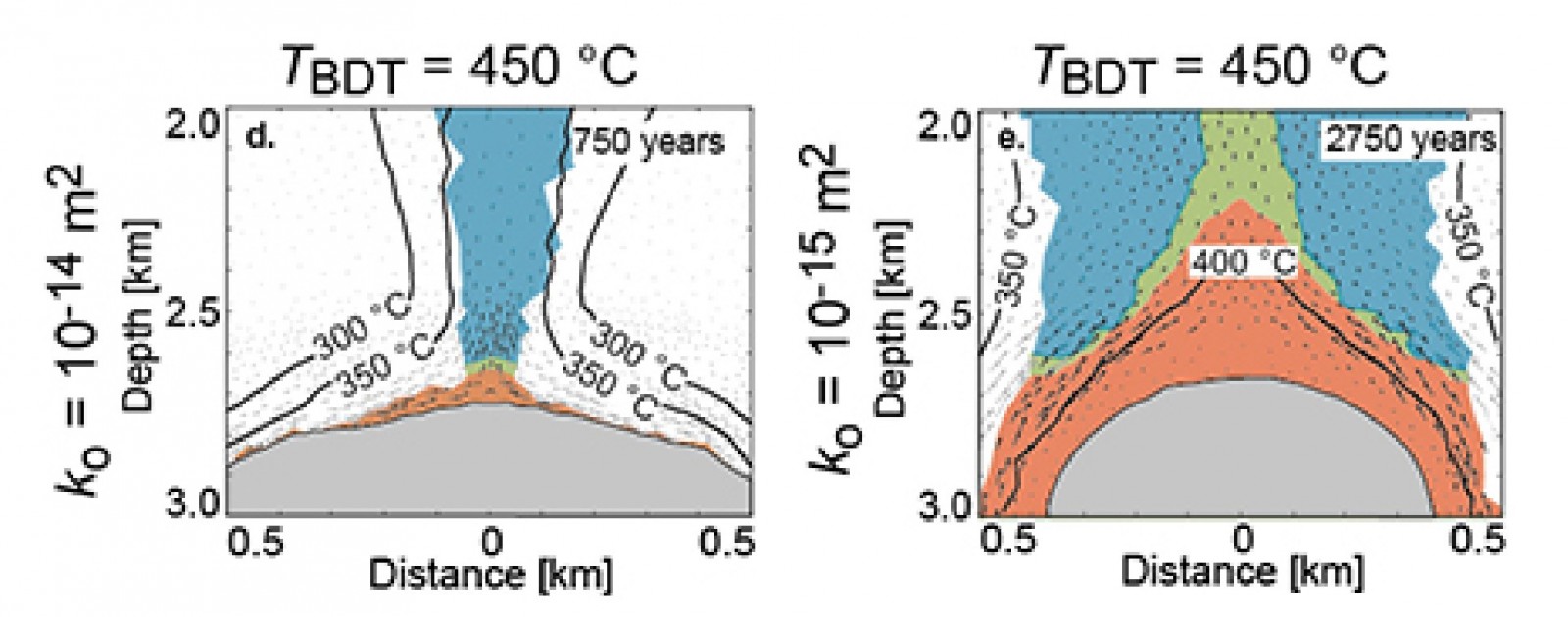
If the rock (white) surrounding an impermeable body of magma (grey) is only highly permeable, supercritical water (red) is restricted to a thin layer around the magma (left panel). However, if the rock is moderately permeable, a large area can be heated to supercritical conditions (right panel). (Illustration: from Scott et al. 2015, Nature Comm.)
Our models were able to reproduce measured data from the IDDP well when the geologic controls are set to appropriate values for the Krafla system. This supports the model set-up, as well as the conclusion that supercritical geothermal resource properties depend on geologic controls. Moreover, the models show that conventional geothermal resources result simply from the mixing of supercritical fluids ascending from the intrusion and cooler fluids circulating near the intrusion but not heated to supercritical conditions. This is a new way to look at conventional high-enthalpy geothermal reservoirs.
In future studies, we will seek to better understand the role of supercritical water in controlling the thermal structure and temporal evolution of high-enthalpy geothermal systems. As our understanding progresses, we will move towards modeling specific geologic settings, including the Reykjanes geothermal system where the next IDDP well will be drilled. Since the Reykjanes geothermal field contains groundwater that is known to have a large seawater component, fluid salinity is likely to play a key role on supercritical resource formation and properties. Salt changes the thermodynamic properties of water such as density and viscosity and allows boiling to occur at higher temperatures and pressures than for pure water. This may affect the formation of similar supercritical reservoirs in unexpected ways.
Although this was not the outcome the IDDP expected, the fact that such a reservoir was encountered on the first intentional effort suggests they may be a common feature that we have been passing up by targeting reservoirs at shallower depths. It also means that targeting supercritical geothermal resources may be even more economically attractive than expected by the IDDP, since wells do not need to be drilled as deep as expected. Exploiting supercritical water resources has the potential to massively improve the economics of power production from magma-driven geothermal systems. Time will tell whether or not they can be found in systems all over the world, but we anticipate that the search for these fluid reservoirs will continue.
Sustainability of water uses in managed hydrosystems: human- and climate-induced changes for the mid-21st century
Words on Wednesday aims at promoting interesting/fun/exciting publications on topics related to Energy, Resources and the Environment. If you would like to be featured on WoW, please send us a link of the paper, or your own post, ERE.Matters@gmail.com
****
Citation: Fabre, J., Ruelland, D., Dezetter, A., and Grouillet, B.: Sustainability of water uses in managed hydrosystems: human- and climate-induced changes for the mid-21st century, Hydrol. Earth Syst. Sci. Discuss., 12, 9247-9293, doi:10.5194/hessd-12-9247-2015, 2015.
Abstract. This paper assesses the sustainability of planned water uses in mesoscale river basins under multiple climate change scenarios, and contributes to determining the possible causes of unsustainability. We propose an assessment grounded in real-world water management issues, with water management scenarios built in collaboration with local water agencies. Furthermore we present an analysis through indicators that relate to management goals and present the implications of climate uncertainty for our results, furthering the significance of our study for water management. A modeling framework integrating hydro-climatic and human dynamics and accounting for interactions between resource and demand was developed and applied in two basins of different scales and with contrasting water uses: the Herault (2500 km2, France) and the Ebro (85 000 km2, Spain) basins. Natural streamflow was evaluated using a conceptual hydrological model. A demand-driven reservoir management model was designed to account for streamflow regulations from the main dams. Human water demand was estimated from time series of demographic, socio-economic and climatic data. Environmental flows were accounted for by defining streamflow thresholds under which withdrawals were strictly limited. Finally indicators comparing water availability to demand at strategic resource and demand nodes were computed. This framework was applied under different combinations of climatic and water use scenarios for the mid-21st century to differentiate the impacts of climate- and human-induced changes on streamflow and water balance. Results showed that objective monthly environmental flows would be guaranteed in current climate conditions in both basins, yet in several areas this could imply limiting human water uses more than once every five years. The impact of the tested climate projections on both water availability and demand could question the water allocations and environmental requirements currently planned for the coming decades. Water shortages for human use could become more frequent and intense, and the pressure on water resources and aquatic ecosystems could intensify. The causes of unsustainability vary across sub-basins and scenarios, and in most areas results are highly dependent on the climate change scenario.

Location, main water uses and water management characteristics of (a) the Herault
and (b) the Ebro basins. In the Herault basin, 6 sub-basins matching 6 demand nodes were
defined. In the Ebro basin, 20 sub-basins were selected for the simulation of water resources
and 8 demand nodes matching the main irrigation systems were defined.
How to assess geo-exchange potential for shallow geothermal energy at regional scale?
Words on Wednesday aims at promoting interesting/fun/exciting publications on topics related to Energy, Resources and the Environment. If you would like to be featured on WoW, please send us a link of the paper, or your own post, ERE.Matters@gmail.com
****
By Eloisa Di Sipio
Galgaro A., Di Sipio E., Teza G., Destro E., De Carli M., Chiesa S., Zarrella A., Emmi G., Manzella A. 2015. Empirical modeling of maps of geo-exchange potential for shallow geothermal energy at regional scale. Geothermics, 57, 173-186 doi.org/10.1016/j.geothermics.2015.06.017
In the frame of the economic crisis occurring since 2008 in Europe, the use of renewable energy resources is expected to increase in order to overcome the economic dependence on fossil fuels and ensuring energy supply for the European economic development.
Therefore, in the next future the use of geothermal resource both for power and heat generation is likely to increase, given its ability to meet part of the global energy needs and to produce low levels of greenhouse-gas emissions (GHG), reducing significantly CO2 emissions in the atmosphere.
To assess the geothermal energy exchanging ability of closed-loop Ground Source Heat Pump (GSHP) systems, a specific procedure able to combine ground and GSHP parameters was developed.
The methodology is based on different input parameters: i) the thermal conductivity of the ground, ii) the undisturbed ground temperature at 50 meters depth b.g.l. and iii) the monthly energy loads of the building considering a standard case study. The maximum energy requirements in a year has been estimated for a reference residential building (100 m2) with standard insulation and transmittance, according to the normative UNI EN ISO 6946, and usual requirements on heat pump efficiency (coefficient of heating performance COP =4.5 and cooling energy efficiency ratio EER = 4.0). The parameter adopted to link the ground thermal properties to the building thermal requirements is the total length (Ltot) of the group of vertical borehole heat exchangers (BHE) required to satisfy the energy building needs of the reference building.
Since the modeling has empirical character, it was applied to four regions of Southern Italy within the VIGOR Project (http://www.vigor-geotermia.it/). The obtained geo-exchange potential maps are conceived for energy planning purposes at regional scale and, due to the complexity of the different system components (house type, geological conditions, heating/cooling needs), provide a first and rough estimation of the geo-exchange potential of the areas taken into consideration. They do not replace detailed site-specific analyses, which, instead, are necessary for GSHP design purposes.
However, the proposed methodology can be easily exported in other contexts were use of shallow geothermal resources is planned. In fact the maps show the thermal energy that could be exchanged through the unit area by BHEs for a recent or a recently renovated building, taking into account the local geological and climatic conditions. Higher values of the geo-exchange potential identify more suitable place for shallow geothermal exploitation, implying a lower total length of the BHE field required for the GSHP system and then lower installation costs.
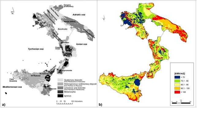
Main geological features (a) and geo-exchange potential maps for shallow closed loop systems (b) of four Southern Italy regions.
Eloisa Di Sipio is currently a post-doctoral researcher at the Institute of Geosciences and Earth Resources (IGG) of the National Research Council (CNR), Italy. Awarded in 2015 of a Marie Sklodowska Curie (MSC) fellowship, she will start the research cooperation with the Friedrich-Alexander-Universität, Germany, in November 2015. Main research interests concern shallow geothermal energy resources, hydro-geological topics and petrophysical characterization of lithological materials. She is involved also in dissemination and outreach activities addressed to general public. Eloisa is currently chair of the Early Career Hydrogeologist Network – Italy (ECHN-Italy) and member of the International Geothermal Association (IGA).
For more information, you can contact her at eloisa.disipio@gmail.com, or follow her on the LinkedIn or ResearchGate pages.