ERE
Energy, Resources and the Environment

ERE Matters

The main goal of the Energy, Resources and the Environment (ERE) Division is to be a leading forum on discussions regarding the provision of adequate and reliable supplies of affordable energy and other resources, in environmentally sustainable ways. As such, it has many links to the other EGU Divisions, such as Hydrology, Natural Hazards, and Tectonics and Structural Geology.

Words on Wednesday: Effects of soil settlement and deformed geometry on a historical structure

Words on Wednesday aims at promoting interesting/fun/exciting publications on topics related to Energy, Resources and the Environment. If you would like to be featured on WoW, please send us a link of the paper, or your own post, at ERE.Matters@gmail.com.

***

Yardım, Y. and Mustafaraj, E., 2015. Effects of soil settlement and deformed geometry on a historical structure, Nat. Hazards Earth Syst. Sci., 15, 1051-1059, doi:10.5194/nhess-15-1051-2015.

Abstract:

Protecting the historical character of a valued structure during the assessment and damage repair process is a very challenging task for many engineers. Heritage protection is complicated by a lack of design details and restrictions on sample extraction needed to obtain accurate material properties and limited studies on the restoration of certain types of historical structures. This study aims to assess the effects of soil settlement on a structure’s stress concentrations and the value of laser scanning techniques on structure analysis in obtaining correct data of settlement vs. deformation. Terrestrial laser scanner (TLS) data are used to analyse the 500-year-old historical structure of Naziresha’s Mosque. The obtained TLS data allow an accurate definition of the imperfect geometry patterns lying on every side of the structure. The soil profile and general crack formation together with TLS measurement proves that the structure deformed toward the south façade, where a railway and motorway are also located. Stress concentration and mode period results have a considerable difference, which highlights earthquake vulnerability and failure mechanisms and changes the strategy of possible retrofitting.

Cracks due to differential settlement (d = 18 cm) in the south façade (May 2012).

Cracks due to differential settlement (d = 18 cm) in the south façade (May 2012).

The mysterious subsidence of the seafloor due to oil production – How to predict it with a simple model?

by Daniel Keszthelyi
Physics of Geological Processes group at the Department of Physics, University of Oslo

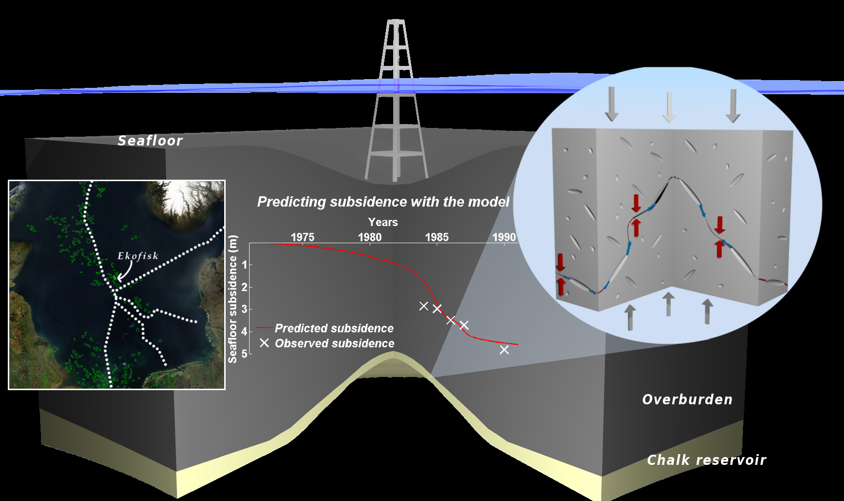
Over 40 years of oil production from the Ekofisk field caused the overlying seafloor to sink over 9 meters during the years and while there have been numerous researches on the topic; the clear understanding of what happens with the reservoir rocks during production is still missing. We created a simple model of compaction with physics-based assumption to estimate the magnitude of the subsidence.

The Ekofisk field situated some 320 km off the coast of Norway is one of the largest petroleum fields of the country. Oil is produced from carbonate rocks (chalk) lying almost 3 km below the seabed to an oil platform standing in 76 meter deep water. The depletion of oil from the carbonate rocks caused a dramatic decrease in the pore pressure in these rocks and in turn a large increase in the effective stress acting to them. This increased effective stress then led to their compaction which was much more significant than expected by previous models.

The compaction has positive effect on the oil production as it pushes out oil from the rock; however it also puts at risk the surface facilities (oil platform and pipelines) and decreases the permeability of the rock making the flow of fluids inside them more difficult.

Our new model of compaction is based on very simple assumptions and describes rock as a collection of pores where these pores are material weaknesses. Imagine a sheet of paper with a small cut made in the middle of the paper. Then if you try to tear or shear the paper slowly you can see that this cut starts to grow until the sheet of paper is torn into two pieces. Similar things happen to the rock if effective stresses are increased: the pores – like the small cut in the middle of the sheet of paper – will become nuclei of new fractures and eventually a fracture network will be created. According to linear elastic fracture mechanics the larger the pore the less stress is needed to involve it into fracturing and vice-versa the larger the stress the smaller pores can be fractured: so with increasing effective stresses considerably more fractures can be created.

The Ekofisk field: location, mechanism of compaction and predicted subsidence (by Daniel Keszthelyi)

The Ekofisk field: location, mechanism of compaction and predicted subsidence (by Daniel Keszthelyi)

Fluids originally inside the pores can flow into these new fractures and if the fluid is water or partly water it can dissolve the material of rock: in carbonates calcite. The exact mechanism is called pressure solution which vaguely speaking means that the solubility of calcite depends on the pressure and therefore it can dissolve at grain-grain contacts along the new fracture and precipitate anywhere else. According to our model this dissolution will lead to the compaction of the carbonate rock.

The speed of dissolution can be calculated from pressure solution theories and the number of fractures can be calculated by statistical means and therefore the speed of deformation (the strain rate) can be predicted knowing some parameters without using any fitting parameters. All we have to know is porosity, pore size distribution, effective stress, water saturation, temperature and how the solubility of calcite depends on pressure and temperature: all of these can be measured independently in laboratory experiments.

If we apply this model to the Ekofisk field using an estimated pressure history of the reservoir we get quite good agreement with the measured subsidence values. This means that with a very simple model with no fitting we are able to predict the subsidence of the Ekofisk field. Furthermore, with simple modifications might also help to better understand other subsidence cases related to oil, gas or water production.

This post is based on the EGU talk Compaction creep by pore failure and pressure solution applied to a carbonate reservoir by Daniel Keszthelyi, Bjørn Jamtveit and Dag Kristian Dysthe. Daniel Keszthelyi is a PhD candidate at the Physics of Geological Processes group at the Department of Physics, University of Oslo. For further information please contact daniel.keszthelyi @fys.uio.no.

Words on Wednesday: The ocean carbon sink – impacts, vulnerabilities and challenges

Words on Wednesday aims at promoting interesting/fun/exciting publications on topics related to Energy, Resources and the Environment. If you would like to be featured on WoW, please send us a link of the paper, or your own post, at ERE.Matters@gmail.com.

***

Heinze, C., Meyer, S., Goris, N., Anderson, L., Steinfeldt, R., Chang, N., Le Quéré, C., and Bakker, D. C. E., 2015. The ocean carbon sink – impacts, vulnerabilities and challenges, Earth Syst. Dynam., 6, 327-358, doi:10.5194/esd-6-327-2015.

Abstract:

Carbon dioxide (CO2) is, next to water vapour, considered to be the most important natural greenhouse gas on Earth. Rapidly rising atmospheric CO2 concentrations caused by human actions such as fossil fuel burning, land-use change or cement production over the past 250 years have given cause for concern that changes in Earth’s climate system may progress at a much faster pace and larger extent than during the past 20 000 years. Investigating global carbon cycle pathways and finding suitable adaptation and mitigation strategies has, therefore, become of major concern in many research fields. The oceans have a key role in regulating atmospheric CO2 concentrations and currently take up about 25% of annual anthropogenic carbon emissions to the atmosphere. Questions that yet need to be answered are what the carbon uptake kinetics of the oceans will be in the future and how the increase in oceanic carbon inventory will affect its ecosystems and their services. This requires comprehensive investigations, including high-quality ocean carbon measurements on different spatial and temporal scales, the management of data in sophisticated databases, the application of Earth system models to provide future projections for given emission scenarios as well as a global synthesis and outreach to policy makers. In this paper, the current understanding of the ocean as an important carbon sink is reviewed with respect to these topics. Emphasis is placed on the complex interplay of different physical, chemical and biological processes that yield both positive and negative air–sea flux values for natural and anthropogenic CO2 as well as on increased CO2 (uptake) as the regulating force of the radiative warming of the atmosphere and the gradual acidification of the oceans. Major future ocean carbon challenges in the fields of ocean observations, modelling and process research as well as the relevance of other biogeochemical cycles and greenhouse gases are discussed.

Mean unweighted surface water fCO2 (μatm) for the years 1970–2002 (a) and 2003–2011 (b) using the SOCATv2 monthly 11 degree gridded data set (Bakker et al., 2014). The maps were generated by using the online Live Access Server.

Mean unweighted surface water fCO2 (μatm) for the years 1970–2002 (a) and 2003–2011 (b) using the SOCATv2
monthly 11 degree gridded data set (Bakker et al., 2014). The maps were generated by using the online Live Access Server.

The Pore Space Scramble

by Alexandra Gormallya and Michelle Benthamb
aLancaster Environment Centre, Lancaster University, Lancaster, LA1 4YQ, UK; bBritish Geological Survey, Keyworth, Nottingham, NG12 5GG, UK

The underground is being used more to help us meet some of the challenges facing humans from tackling climate change, waste disposal to ensuring energy security. The notion of ‘pore space’ and its commodification, has gained much momentum over the last few years in policy circles, industry and the natural (geo)sciences alike. However ‘pore space’ and the use of the underground is now also being discussed within the social sciences too. Human geographers in particular are starting to critically discuss some of the ways in which society uses, perceives and interacts with the subsurface in the past, present, and different ways of how this might happen in the future. Through this examination, social scientists are beginning to interact with geoscientists. This has led to a collaborative engagement between human geographers in the Lancaster Environment Centre, with geoscientists at the British Geological Survey. Through this collaboration the notion of The Pore Space Scramble was born.

So, what is pore space and why might there be such a scramble for its use? Pore spaces are voids between rock grains that contain liquid or gas. The connection of pores then form pathways in which water, oil or gas can move. The interest in pore space therefore, is of interest due to its potential to store materials such as heat, gas or water. Uses of the pore space form a complex system so to simplify this we frame our discussion around the use of pore space for the long-term storage of CO2 as a result of Carbon Capture and Storage (CCS). CCS is a suggested route to decarbonising the power and industrial sectors.

Going down in scale: from the outcrop to the pore space (by the British Geological Survey)

Going down in scale: from the outcrop to the pore space (by the British Geological Survey)

There is strong political will behind CCS both at the European level and in the UK itself [1], the UK setting out a 3 phase road map to commercialise CCS going forward. Given this political drive, it is not only necessary to understand the technical capabilities and practical ability to take this technology forward it also raises many questions around society and governance of such a system into the future. For example, who has precedence over this space and how does it compete with other energy infrastructure on both the surface and subsurface (eg. oil & gas industry, windfarms)? What are the legal and regulatory standpoints of this space i.e. who owns the pore space and therefore legally be able to utilise its use? What are the long-term stewardship plans of this space (eg. 10, 100, 1000 years), how does this effect liability and how might the precedence of such industries change over time? Ultimately, how do we ethically and justly govern such a space both presently and when projected into the future?

Demands on the subsurface (by the British Geological Survey)

Demands on the (sub)surface (by the British Geological Survey)

We do not currently have answers for these questions but are initiating and undertaking research in this area as well as highlighting the need for policymakers, scientists, academic and publics to negotiate the challenges the subsurface will face going forward.

Reference:

  1. DECC (2012). CCS Roadmap: Supporting deployment of Carbon Capture and Storage in the UK < www.gov.uk/government/uploads/system/uploads/attachment_data/file/48317/4899-the-ccs-roadmap.pdf > Accessed: 10/06/2015.