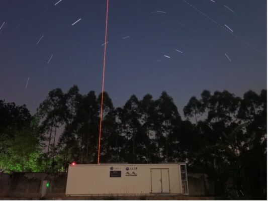
When we gaze at the sky, our eyes often linger on blue horizons, floating clouds, or twinkling stars—rarely do we think about the critical processes unfolding 80 to 100 km above ground. This region, known as the mesopause, acts as a vital transition zone for aviation and aerospace activities (not vital for routine commercial aviation, but it is indispensable for high-altitude aerospace, experimental aviation, spacecraft re-entry/launch, and the broader atmospheric models that underpin all aviation operations), where subtle changes in temperature and wind can shape global atmospheric circulation. Now, a team from the University of Science and Technology of China (USTC) has used a cutting-edge sodium lidar in Hainan (19°N, 109°E, Figure 1) to reveal, for the first time, the seasonal variations of gravity wave-driven heat and sodium fluxes in this poorly understood low-latitude region.
A High-Precision “Eye” on the Upper Atmosphere
To explore the mesopause, the team developed a narrowband sodium lidar—an advanced remote sensing tool that uses laser light to probe atmospheric properties. Operating at a wavelength of 589 nanometers, this system features state-of-the-art laser frequency-locking and real-time monitoring technology, achieving an impressive frequency stability of 0.5 megahertz (RMS). This precision ensures accurate measurements of sodium atom density, temperature, and vertical wind in the upper atmosphere.
The lidar consists of three core components: a transmitter that emits pulsed laser beams, a 1-meter diameter telescope that collects backscattered photons from atmospheric sodium atoms, and a signal processing module that converts photon counts into scientific data. Since February 2024, the system has operated continuously, accumulating over 326 hours of valid observations—laying the groundwork for groundbreaking insights.
Key Discovery: Double Peaks and Low-Latitude Uniqueness
The team’s analysis yielded a series of remarkable findings, centered on the dual dynamics of heat and sodium transport.
The annual average vertical heat flux over Hainan shows two distinct downward peaks: -1.21 K m s-1 at 89 km and -1.38 K m s-1 at 92 km. This dual-peak structure contrasts sharply with mid-latitude sites like Hefei (China), where a single peak dominates. The divergence of these heat fluxes drives a cooling rate of approximately 95 K day-1 between 82 and 97 km—comparable in magnitude to radiative cooling—highlighting gravity waves as key regulators of the mesopause’s thermal balance (see Figure 2).
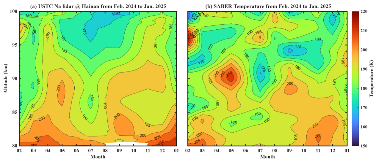
Figure 2: Monthly mean of nightly mean temperature observed by (a) lidar and (b) SABER. Taken from Wang et al. (2026, AMT, 10.5194/amt-19-1629-2026), their Figure 10.
Sodium atoms serve as natural “tracers” for atmospheric motion. The observations revealed sodium flux peaks exceeding -65 m s-1 cm-3 at 92 km, leading to a maximum net sodium loss of 75 cm-3 h-1 near 93 km. Notably, Hainan’s sodium flux magnitude falls between those of mid-high latitude stations and Hawaii’s Maui (20.7°N), reflecting the unique dynamical characteristics of low-latitude air circulation. Crucially, the lidar data aligns closely with measurements from the SABER satellite. For example, temperatures below 95 km peak in May and November, with seasonal trends matching satellite observations—validating the reliability of the lidar’s results.
Why this matters
The mesopause is a critical interface between Earth’s middle and upper atmosphere, where gravity wave activity, material transport, and energy exchange shape global circulation and space weather. Although the mesopause, located 80-100 kilometers above the ground, is far from us, its cooling effect will affect the global atmospheric circulation on the ground through a series of chain reactions: The cooling here is caused by gravity waves propagating upward to this region, breaking, and releasing energy. This energy does not disappear out of thin air; it transmits momentum downward to the stratosphere, first accelerating the high-altitude winds in the stratosphere. The stratosphere is closely connected to the troposphere (the atmospheric layer where we live), so the winds in the stratosphere will further drive and change key atmospheric circulation systems in the troposphere, which are the core drivers of surface storms, monsoons, and the movement of cold and warm air. Meanwhile, the strong cooling at the mesopause will also increase the temperature difference between cold and warm in the tropical stratosphere. The greater the temperature difference, the stronger the wind, which in turn makes the atmospheric circulation in the troposphere more active, ultimately affecting global weather patterns.
This research provides the first systematic lidar-based dataset on low-latitude mesopause fluxes, offering valuable insights for aerospace engineering, satellite orbit prediction, and atmospheric modeling. For instance, precise temperature and wind profiles improve the safety of spacecraft reentries and high-altitude flights by accounting for upper atmospheric variability.
For more details, access the full observational dataset via the Science Data Bank or explore the SABER satellite’s public data repository. Stay tuned for future articles diving deeper into the lidar’s technical innovations, observation site selection, and advanced data processing methods!
The mysteries of the sky extend far beyond what meets the eye. As this Hainan-based lidar continues to monitor the mesopause, it promises to unlock more secrets of Earth’s upper atmosphere—contributing vital Chinese data and solutions to global atmospheric science.