EGU Blogs

499 search results for "Imaggeo on Mondays"

GeoLog

Imaggeo on Mondays: A Patagonia landscape dominated by volcanoes

Imaggeo on Mondays: A Patagonia landscape dominated by volcanoes

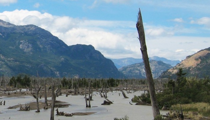
Imagine a torrent of hot and cold water, laden with rock fragments, ash and other debris hurtling down a river valley: this is a lahar. A by-product of eruptions of tall, steep-sided stratovolcanoes, lahars, are often triggered by the quick melting of snow caps and glaciers atop high volcanic peaks. The history of the Ibañes River and its valley, in southern Chile, are dominated by their proximity ...[Read More]

GeoLog

Imaggeo on Mondays: High altitude glacier monitoring

Imaggeo on Mondays: High altitude glacier monitoring

What a place to work: Spectacular views from the top of the rugged and icy peaks of Tien Shan mountain range. The desire to better understanding global climate change took Leo Sold to this remote area of Central Asia. The frozen slopes of ice and snow in today’s Imaggeo on Mondays photograph hold some of the keys to understanding how the glaciers in this remote region are being affected by a warmi ...[Read More]

GeoLog

Imaggeo on Mondays: Fly away, weather balloon

Imaggeo on Mondays: Fly away, weather balloon

Some aspects of Earth Science are truly interdisciplinary and this week’s Imaggeo on Mondays photograph is testament to that. The maiden voyage of the research cruise SA Agulhas II offered the perfect opportunity to combine oceanographic research, as well as climate science studies. Raissa Philibert, a biogeochemistry PhD student, took this picture of the daily release of a weather balloon by mete ...[Read More]

GeoLog

Imaggeo on Mondays: Landslide on the Cantabrian coastline

Imaggeo on Mondays: Landslide on the Cantabrian coastline

Shimmering blue seas, rocky outcrops and lush green hills sides; this idyllic landscape is punctuated by a stark reminder that geohazards are all around us. Irene Pérez Cáceres, a PhD student at the University of Granada (Spain) explains the geomorphology behind this small scale landslide on the Asturian coastline. This picture was taken in May 2011 in the coast of Llanes (Asturias, Spain). I was ...[Read More]

GeoLog

Imaggeo on Mondays: A solitary floating island

Imaggeo on Mondays: A solitary floating island

With 2014 officially named the hottest year on record, there is evidence of the effects of rising global temperatures across the globe. The solitary, shimmering iceberg in today’s Imaggeo on Mondays photograph is a reminder that one of the best places to look for evidence of change is in glaciers. Daniela Domeisen tells the story of this lonely frozen block of ancient ice. The picture shows an ice ...[Read More]

GeoLog

Imaggeo on Mondays: Artists’ Paint Pots

Imaggeo on Mondays: Artists’ Paint Pots

Many artists draw inspiration from nature and it’s not surprising when faced with landscapes which are as beautiful as the one featured in this week’s Imaggeo on Mondays post. Josep Miquel Ubalde Bauló writes about the origin of the colourful mud pots and bobby-socks trees! This picture corresponds to The Artist Paint Pots, found in in Yellowstone, the first National Park of the world. Yellowstone ...[Read More]

GeoLog

Imaggeo on Mondays: Iceberg at midnight

Imaggeo on Mondays: Iceberg at midnight

Standing on the vast expanse of gleaming white sea ice of the Atka Bay, Michael Bock took this stunning picture of an Antarctic iceberg. The days, during the Antarctic summer, are never ending. Despite capturing the image at midnight, Michael was treated to hazy sunlight. “Clearly visible [in the iceberg] are the annual snow accumulation layers which illustrate how the ice archive works.; as you l ...[Read More]

GeoLog

Imaggeo on Mondays: Lusi from the sky with drones

Imaggeo on Mondays: Lusi from the sky with drones

The picture shows a spectacular aerial view of a sunset over the Lusi mud eruption in East Java, Indonesia. Here thousands of cubic meters of mud, are spewed out every day from a 100 m sized central crater. Since the initial eruption of the volcano in 2006, following a 6.3 M earthquake, a surface of about 7 km2 has been covered by boiling mud, which has buried more than 12 villages and resulted in ...[Read More]

GeoLog

Imaggeo on Mondays: Wadis in a war zone

Imaggeo on Mondays: Wadis in a war zone

The range of challenges scientists face when carrying out Earth science research in the field are vast. However, the story behind Vincent Felde’s, a PhD candidate at Giessen University, image of the wadi, is truly remarkable and highlights how geoscientific research is not limited by borders or conflict. Wadi Nizzana (the Arabic term used to describe valleys that remain dry except during times of ...[Read More]

GeoLog

Imaggeo on Mondays: A single beam in the dancing night lights

Imaggeo on Mondays: A single beam in the dancing night lights

Research takes Earth scientists to the four corners of globe. So, if you happen to have a keen interest in photography and find yourself doing research at high latitudes, chances are you’ll get lucky and photograph the dancing night lights: aurora (or northern lights), arguably one of the planet’s most breath taking natural phenomenon. That is exactly the position Matias Takala, a researcher at th ...[Read More]