EGU Blogs

Matt Herod

Matt Herod is a Ph.D Candidate in the Department of Earth Sciences at the University of Ottawa in Ontario, Canada. His research focuses on the geochemistry of iodine and the radioactive isotope iodine-129. His work involves characterizing the cycle and sources of 129I in the Canadian Arctic and applying this to long term radioactive waste disposal and the effect of Fukushima fallout. His project includes field work and lab work at the André E. Lalonde 3MV AMS Laboratory. Matt blogs about any topic in geology that interests him, and attempts to make these topics understandable to everyone. Tweets as @GeoHerod.

Geology Photo of the Week #46

This week’s photo brings us back to the world of geochemistry. I don’t have much information on this photo beyond that it was taken in Italy.  However, if I may speculate a little it looks like these crystals may possibly be volcanic in origin and the fact that it was taken in Italy, which is famous for its volcanic sulphur deposits. I say this because such crystals are often found near active volcanoes and form from the degassing of sulphur dioxide (SO2) and hydrogen sulphide (H2S) gas from vents known as fumaroles. Groundwater dissolves gases and mineral rich in sulphur at high temperatures however, once the water reaches the low pressure atmosphere of the Earth’s surface these gases are released from the water and native sulphur precipitates.

Close-up of sulphur crystals with condensation drop by Ulrich Kueppers

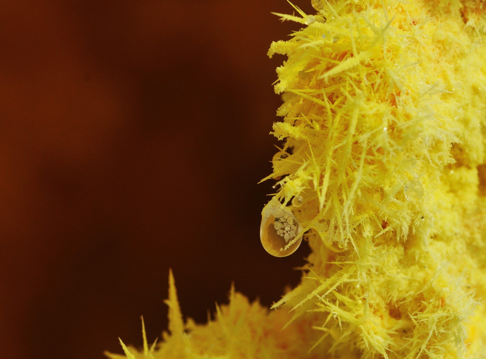
Close-up of sulphur crystals with condensation drop by Ulrich Kueppers. Source

I JUST SUBMITTED MY THESIS!!

As you may have gathered from my enthusiastic title I just submitted my thesis! After 6 years of hard work it’s been passed in. To celebrate I decided to make this really cool word cloud showing the most frequently occurring words in the thesis, which currently contains a total of 55,713 words. The bigger the font the more common the word. As you may notice 129I occurs a lot, 1,220 times to be exact, since it is the topic of the entire thing. WordCloud

Here is a pic of the whole thing ready to turn in to the grad studies office. Now that this thing is done hopefully I’ll be able to get back to blogging a little more frequently. Actually, I have ideas for several posts saved up including summaries of a few of my thesis chapters.

IMG_20150812_145309

By the way, I lied above. I’m going to get a beer to celebrate. Cheers!

Geology Photo of the Week #45

This weeks photo is once again related to permafrost and the Arctic….something tells me I miss being there.

Anyway, the gorgeous photo below shows a terrific example of polygonal patterned ground from Siberia. Patterned ground is a phenomenon that occurs frequently in cold regions and is caused by the seasonal freeze-thaw of the active layer/soil. This process can produce a phenomenon called ice wedges that extend deep into the permafrost (see my photo of a large ice wedge below) as water infiltrates into a crack freezing it and expanding it. This repeats annually as the ice cracks due to the extreme cold and is then filled by new meltwater from the active layer, which freezes.

Ice wedges have excellent potential as a climate research tool as they can be very old and preserve the isotopic signature of each new year’s water. In fact, my research group has an MSc. student working on this exact thing.

Sorting of sediments by the freeze thaw of groundwater also creates patterned ground as the process forces larger sediments upward and lets smaller sediment settle eventually creating little piles of rocks on the ground surface. However, in the case of the photo below, which is in a poorly drained peatland, there are likely lots of ice wedges.

Wet Sedge Polygons on Samoylov Island with Stolb Island in the background - Samoylov Island - Lena River Delta - 20.08.2010 - Sebastian Zubrzycki

Wet Sedge Polygons on Samoylov Island with Stolb Island in the background – Samoylov Island – Lena River Delta – 20.08.2010 – Sebastian Zubrzycki

Ice wedge along the Dempster Hwy. in the Yukon.

Partially collapsed ice wedge in cross section along the Dempster Hwy. in the Yukon. (Photo: Matt Herod)

Thaw Slumps of the NWT

I recently across an article that reminded me of my field work days in the early stages of my PhD in the Canadian Arctic at retrogressive thaw slumps. The article discusses the impending catastrophic drainage of a lake when the thin strip of land separating it from a thaw slump fails (see article), which it will inevitably do very soon. The story has now been picked up all across Canada in the context of climate change and permafrost melting. It was nice to see thaw slumps and permafrost in the news so I thought I’d post a few of my own pictures of these slumps from a few years ago that are very nearby the one in the article. Actually, we worked on these same slumps with Dr. Steve Kokelj from the NWT geological survey who is quoted.

Here are few of my own slump pictures from my fieldwork days in the NWT.

IMG_2860

An aerial view of the Charras slump, which is approximately 1 km across and 30m deep at the headwall. (Photo: Matt Herod – 2011)

IMG_2855

An aerial view of one of the smaller slumps. (Photo: Matt Herod – 2011)

IMG_2830

My colleague, Bernard, from the uOttawa geography department headed towards the headwall for an ice sample. (Photo: Matt Herod – 2011)

IMG_2817

A rainy day in the slump. The mudflow becomes really active when the weather is wet. (Photo: Matt Herod – 2011)