EGU Blogs

Matt Herod

Matt Herod is a Ph.D Candidate in the Department of Earth Sciences at the University of Ottawa in Ontario, Canada. His research focuses on the geochemistry of iodine and the radioactive isotope iodine-129. His work involves characterizing the cycle and sources of 129I in the Canadian Arctic and applying this to long term radioactive waste disposal and the effect of Fukushima fallout. His project includes field work and lab work at the André E. Lalonde 3MV AMS Laboratory. Matt blogs about any topic in geology that interests him, and attempts to make these topics understandable to everyone. Tweets as @GeoHerod.

Geology Photo of the Week #44

For a bit of a change of pace the photo of the week this week isn’t a photo at all. Rather it’s a fascinating model output showing ocean surface currents in the North Atlantic. The Gulf Stream is clearly visible as it flows past Atlantic Canada and out towards the middle of the north Atlantic. I am guessing that colour scheme has something to do with current velocity or mass flux or something. Anyway, I think that red means a bigger current than blue.

Modelling is something that I have written briefly about before and am starting to get involved with in my own work. It’s a fascinating field although I believe that all model results should be taken with a grain of salt given that they try to mimic and quantify what is actually happening in nature but cannot always incorporate all of the inter-relationships that exist between the variables. This makes them only representations of what is actually occurring in the real world. However, the insane level of complexity in real systems makes models the only way to try and understand processes that we can’t observe easily. As we learn more the model can then be adjusted to incorporate new linkages and their importance more accurately.

Enough of my ranting, enjoy this unique and beautiful model output of the north Atlantic’s currents.

3b3367d54c0e5eccb464f3b770d1f53b

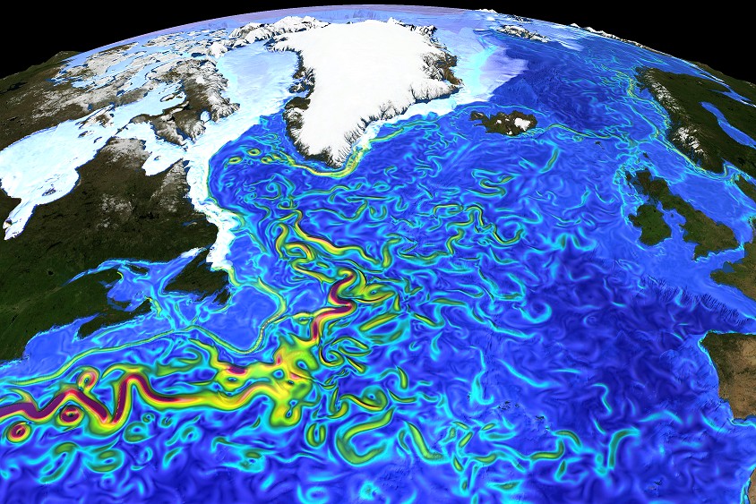
Surface currents in the North Atlantic– by Erik Behrens, GEOMAR, Kiel, Germany Snapshot of surface speed in a eddying (0.05°, VIKING20) ocean sea-ice model resolving important mesocale eddies and filaments explicitly.

Geology Photo of the Week #43

This weeks photo can be described by one word: mesmerizing.

Honestly, it’s hard to tell which part of this photo is better, the beautiful starry sky backdrop or the glow of Kilauea’s smoking crater. Combined, it’s just fantastic.

Kilauea is part of the Hawaiian Island volcanic chain which has been formed as the Pacific plate has moved across at hotspot. The volcano is about 300,000 to 600,000 years old.

Lava glow and space at the Kilauea volcano by Andreas Johnsson “Photo that unites the dynamic Earth and its place in Space. The photo was taken during the NASA-Nordic Winter School in Astrobiology in Hawai’i.”

Geology Photo of the Week #42

This week’s photo is a beautiful example of geochemistry in action. Briefly, travertine, which is composed of CaCO3 is often precipitated at hot springs as they emerge from the ground forming these gorgeous terraces. The reason for their formation is Henry’s gas law in action which states “the solubility of a gas in a liquid is directly proportional to the partial pressure of the gas above the liquid” which in this case is the open air. At depth, the superheated water contains lots of dissolved carbon dioxide, which lowers the water pH and allows it to dissolve carbonate minerals it comes in contact with. However, once the water reaches the surface the CO2 degasses because of the much lower partial pressure (concentration) of CO2 in the atmosphere à la Henry’s law. This causes the pH to rise which in turn leads to precipitation of dissolved carbonates such as aragonite and calcite (travertine).

By the way, I have always, always wanted to swim/lounge in one of these sorts of places but have never had the chance. Maybe one day!

Mammoth Hot Springs – travertine terrace – Credit: Joern Behrens (distributed via imaggeo.egu.eu)

Photo of the Week # 41

I am furiously writing my Ph.D thesis at the moment. I am close to submitting. I swear! Although, everyone I know says I sound like a broken record when I say this.

Anyway, while I have been doing all this writing I haven’t had much time for blogging, for which I apologize. However, in the interest of breathing some life into this dusty old thing I have decided to re-introduce the photo of the week series. Only this time I’ll be mostly using pics from the EGU geology image repository Imaggeo. It’s fantastic and totally open access!

To get things started lets all admire this really cool example of long range dust transport from the Sahara desert to Greece. While this photo is at the micro scale. I can just imagine this same image as an aerial view of dust blowing across the ocean and the sand in the background as the coastline.

Photo: Konstantinos Kourtidis, Demokritus University of Thrace, Xanthi, Greece Saharan dust was transported northwards, and is visible on this outdoor table in Xanthi, Northeastern Greece. The dust was brought down by a rain shower on the morning of the 23rd of March, and, as the rain evaporated, dust became visible on the objects the rain had fell on. (link)