Firstly, I’d like to express my sincere thanks to Dr Jennifer Clear (Czech University of Life Sciences, Prague) for her input to this blog article.
The first week of February saw dozens of scientists arrive at the Katholieke Universiteit Leuven for the PAGES Focus 4 Workshop. This event brought together geomorphologists, soil scientists, palaeoecologists, archaeologists and palaeolimnologists to discuss how we can better quantify past human impacts on the landscape. It became clear this is a research question of great importance for the present-day management and conservation of terrestrial and aquatic ecosystems, as those tasked with the job must be well-informed of what actually is the ‘natural state’ of a particular environment. However, climatic fluctuations and human activity have modified the landscape to an enormous degree throughout the Holocene (the past ~10 000 years) and beyond. Depending on how far back in time you look, the assessment of the local ‘natural’ condition is highly variable and may well be very different from the landscape observed today. Improving our estimates of human-driven land cover change was therefore the focus of this Workshop, although the approaches and the timescales of interest vary considerably, as we saw during the first two days of oral presentations and poster sessions. For those interested, the book of abstracts is available here and the full line-up of speakers is listed here.
The schedule of the conference saw two full days of talks and poster sessions, followed by a field excursion on Day 3 and finished with two days of detailed small group discussions around specific topics. The breadth of talks was remarkable; those with impressive visual animations really stick in my mind, such as Dan Penny (University of Sydney) showing aerial LIDAR images of Angkor Wat (Linked to recent paper in PNAS). These images are acquired using lasers capable of penetrating dense forest cover; a remarkable pattern of roads, canals and building outlines was revealed after the vegetation cover was computationally removed. Simulations of global land cover changes through the Holocene from Jed Kaplan (many of his animations are available on the ARVE YouTube channel and Kees Klein Goldewijk were really impressive and many impressive vegetation reconstructions across Europe using various models to interpret high-resolution pollen data were also shown. Other case studies showed the dramatic effects of the agricultural revolution on sediment flux and changes in vegetation around the world. Integrating these local datasets to see more of the regional or global picture of land cover change, often termed up-scaling, arose as a focal point of discussion throughout the week and remains a key area of future work.
I was delighted to have been invited to give a talk illustrating how lake sediment sequences can contribute to our understanding of human-environment interactions on various timescales. Examples in my talk included a dramatic spike in sediment flux during the mid-Holocene linked to local human occupation and demonstrating how volumetric assessments of sediment and heavy metal fluxes can be calculated accurately by extracting multiple cores across a single lake basin. My slides are available on FigShare for anyone interested.
The field excursion on Day 3 was a wonderful exploration of the River Dilje catchment, where many of the Workshop organisers have invested considerable time and effort in recent years to establish a comprehensive sediment budget spanning the Holocene (for example, Notebaert et al., 2009). Other stops included a neat site where a chain of large gullies, most likely formed during the Roman occupation in the area, have been preserved beneath forest regrowth (fossilized, in essence), and the L’abbaye de Villers, one of the most impressive ruined Cistercian Abbeys I have visited. We were also treated to a coffee (and cake) stop halfway through the day from a mobile van; something I am keen to introduce to future field work expeditions here in the UK!

L’abbaye de Villers. Photo: D. Schillereff
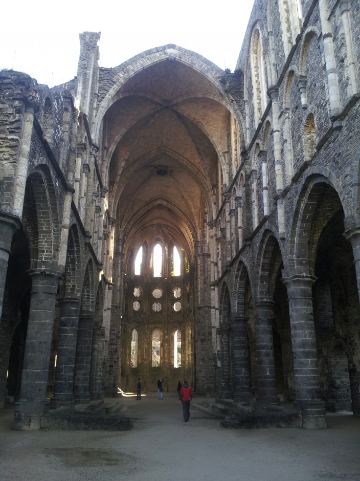
L’abbaye de Villers. Photo: D. Schillereff
The discussion sessions over the final two days were an eye-opening and invaluable experience for me. I’d been advised by experienced colleagues to get involved as much as possible and I certainly felt rewarded for doing so after some of the fascinating debates and knowledge shared from others, especially in the session focused around limnic (lake-derived) and marine sediments. As far as I can recall, I only said one stupid thing where everyone in the room looked at me quizzically! Engaging in the discourse for brainstorming future grant proposals, including identifying opportunities within the new PAGES structure and Future Earth initiative was exceptionally useful, both in terms of possibilities for opening future doors and better understanding the input required to put together large project proposals.
Some final personal observations then… I was surprised by the modest number of delegates whose research focused on lake sediments, because palaeolimnologists investigating records spanning the Holocene or more recent time periods almost always must consider humans as a possible driver of environmental changes captured in the sediment cores. I see many opportunities for further engagement with geomorphologists and soil scientists investigating catchment sediment budgets to link their assessments to lake-based reconstructions. Real progress seemed to be made during this Workshop in terms of sharing data and methodologies between disciplines, which is a great success. After my experience last week, I certainly believe all opportunities for fostering inter-disciplinary conversations on topics of mutual interest should be grasped.