EGU Blogs

Geology Jenga

From mud to moai statue: lake sediments reveal new insights into Easter Island colonization

The small landmass of Easter Island (164 km2), the southeasterly point of Polynesia in the Pacific Ocean, has achieved iconic status in the world today as people wonder how its colonisation was physically possible by settlers journeying through the vast ocean in tiny boats, how and why the enormous moai s were constructed and, most infamously, to what extent they contributed to their own downfall through severe environmental degradation. This story has received a lot of attention, featuring in Jared Diamond’s eye-opening book ‘Collapse’ as well as National Geographic. (Check out the neat video embedded in the National Geographic article in which researchers replicate their theory on ‘walking’ the s).
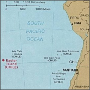
The location of Easter Island related to South America. Used by permission of the University of Texas Libraries, The University of Texas at Austin.

The location of Easter Island related to South America. Used by permission of the University of Texas Libraries, The University of Texas at Austin.

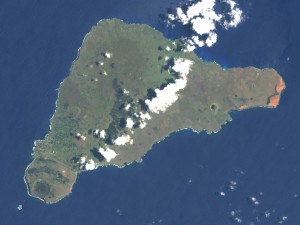
Image of Easter Island from the Earth Observatory, NASA.

Image of Easter Island from the Earth Observatory, NASA.

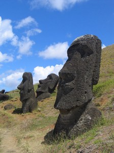
Moai s at Rano Raraku, Easter Island. Source: WikiCommons

Statues at Rano Raraku, Easter Island. Source: WikiCommons

Substantial research efforts have tried to build up a detailed picture of the timing and rate of human settlement and changes in vegetation cover on the island, and most importantly whether there is a clear causal link between the two. Much of the evidence for environmental changes on Easter Island come from lake sediment sequences, a subject close to my heart (having invested 3 years and counting looking at lake sediments for my PhD).
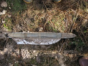
An example of a sediment core extracted from a lake bed. Photo from WikiCommons, courtesy of Gary Rogers.

An example of a sediment core extracted from a lake bed. Photo from WikiCommons, courtesy of Gary Rogers.

In particular, identifying pollen grains at different depths in lake sediment cores can be used to reconstruct what types of plants were growing on the island through time and identify the timing of shifts from a tree-dominated landscape to a more open grassland, for example. I recently found a paper in the journal Quaternary Science Reviews (Cañellas-Bolta et al. 2013, QSR; I apologise that it is not open-access) that I was immediately drawn to as it applied a multi-proxy (integrating different, independent techniques) analytical approach to a new sediment core from a lake on Easter Island. Now, I have thoroughly enjoyed my PhD (so far!); it has been exciting, interesting and the fieldwork has been in the picturesque landscapes of the English Lake District and southern Scotland. Nevertheless, reading this paper set me off on a series of day-dreams because, as lakes are pretty much ubiquitous around the world, maybe one day in the future as part of a successful academic career, I could drill a lake somewhere REALLY cool?!?

A number of hypotheses have been set out to try and explain when settlers first arrived on Easter Island and what triggered the demise of their undoubtedly complex civilisation. One common story is that increased demand for firewood and space for agriculture led to rapid deforestation, severe soil degradation and ultimately cultural collapse. Climatic fluctuations, the introduction of rats, contact with European explorers or simply living in such isolation have also been proposed as drivers of this collapse.
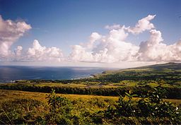
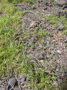
Panoramic view across Hanga Roa, Easter Island. The modern-day 'natural' landscape dominated by open grassland and largely devoid of palm trees is clear to see. Photo from WikiCommons courtesy of Makemake.

Panoramic view across Hanga Roa, Easter Island. The modern-day ‘natural’ landscape dominated by open grassland and largely devoid of palm trees is clear to see. Photo from WikiCommons courtesy of Makemake.

The new data from Cañellas-Bolta et al. include identification of a new pollen type Verbena litoralis and a more refined chronology for their sediment core based on radiocarbon dating. Using radiocarbon dates to identify the timing of events on Easter Island has been problematic due to inverted ages (i.e., a radiocarbon age higher in the sediment sequence returns an older date than samples lower down the core) and hiatuses, or gaps, in the sediment record. The hiatuses are particularly problematic here because sediment accumulation rates are very slow (100 years per cm), thus any gap in the record sadly means a significant chunk of the story has been lost. The authors use the BACON age-depth modelling software package to construct a more robust chronology, as the model incorporates known prior information on sediment accumulation rates and the identification of hiatuses within a Monte Carlo Markov Chain framework (Systematically running many millions of slightly-different simulations based on the same radiocarbon ages) in order to incorporate all possible age distributions, thus doing a better job of accounting for chronological uncertainties.

Verbena litoralis. Photo from WikiCommons, courtesy of Forest & Kim Starr.

Verbena litoralis. Photo from WikiCommons, courtesy of Forest & Kim Starr.

Their vegetation reconstruction suggests Easter Island was dominated by palm trees until ~450 B.C., where the first evidence for a shift in vegetation cover is observed. At this time, grassland and the marker weed species V. litoralis increase in abundance while palm pollen numbers decline, likely suggesting a clearance episode. The replacement of palm-dominated vegetation by herbaceous taxa then continues in a stepped manner, with another major palm decline at ~1200 A.D. This is the most-commonly accepted date for the first Polynesian settlers to the island (~A.D. 800 – 1200) so fits in well with previous work. But the suggestion that human-induced changes in vegetation cover began ~450 B.C., approximately 1500 years earlier, has enormous implications for our understanding of the history of not only Easter Island but also the pattern of settlement across much of Polynesia.

The history of Easter Island has been a topic of intense debate and this paper is another entry into the story. One part of their paper I found particularly neat is that V. litoralis is a weed species native to North America; how then did it arrive on Easter Island nearly 2500 years ago? The authors, after careful consideration of natural dispersal mechanisms, strongly support an interpretation of human-driven spread. They mention other interesting examples such as evidence that sweet potato and bottle gourd, crops native to South America, arrived in Polynesia in prehistoric times and a contemporaneous introduction of Polynesian chickens to Chile.

The authors refrain from making sweeping statements about their findings in terms of re-thinking local and regional history, instead emphasising that many hypotheses remain plausible and there is tremendous scope for future work. I am now mentally planning my mud-extraction expedition as I type…

As a final point, I read Collapse several years ago and was quite taken by the author’s arguments but having read the paper and put together this blog post, I am inspired to conduct a more critical examination of all the information pertaining to Easter Island, especially as I am extremely concerned by the current state of natural environments around the globe and our role in their rapid degradation.

Making the Most of your PhD: Think about the next move

Welcome to the second post in this series of how to make the most of your PhD. If you missed what these posts are all about, check out last week’s post to get all the details!

Credit: Wikimedia Commons, user unknown

Credit: Wikimedia Commons, user unknown

For this post, I wanted to talk about getting some generic (and very transferable, also known as soft) skills. They are the sort of thing any employer, whether you want to continue in an academic career or are thinking of make the move into industry, or even think you might want to go into something totally new, will look for. Trawl through any job ad and you’ll soon see these kinds of skills are important to employers. Unfortunately, how to go about gaining these skills doesn’t lend it’s self to creating a list, like I did last time, so this is more of a word heavy post.

Top Tip #1! Even if you are in the very early stages of your PhD, it is worth while keeping an eye on the job market and checking job descriptions, especially if you know what it is you want to go into once you finish your PhD. This way, you’ll be able to hone, from the start, the kind of skills and experience you’ll need to land your dream job (if such a thing truly exists!).

So, what are these skills I’m talking about? I’m certain the majority of you are familiar with what I mean, but just in case, here are a few examples: leadership, communication, organisational, time management skills, amongst many others etc… The truth is, you’ll get a lot of these through just completing your Phd, but it is important to think about being able to prove you’ve got these skills! You might think about using the Researcher Development Framework (Vitae) to monitor and assess how your skills are developing.

Top Tip #2! Consider signing up to PGR Tips email bulletin from Vitae -it has LOTS of information on how to deal with the challenges of completing a PhD.

Make the most of the resources on offer at your institution. Training for researchers varies from Institution to Institution, but in most cases, you should be able to access training resources (usually on-line) and opportunities (I’m thinking courses) via a ‘Graduate School’. I use inverted commas, because that is how it is know at my University, but it may vary. As part of my doctoral training, I am required to complete a number of training modules specified by my Graduate School (I could write a whole post on whether I’ve found them useful or not), but in addition, I can access a LOT of on-line training resources and other courses, that I’ve been able to complete at my own pace. I’ve targeted that training to address areas where I felt I needed to make improvements. Needless to say, not everything you may come across will be of interest. It is just a good place to start looking for opportunities.

Top Tip #3!  If you aren’t familiar with your ‘graduate school’ website, I encourage you to visit it now!

VITAE

An organisation that works towards the professional development of early career researchers.  Vitae often works in partnership with Universities, research organisations and funders, so it is worthwhile finding out if your institution has links to Vitae as you may well be able to take advantage of what training they have on offer. Even if that is not the case, their website is full of information about the PhD process and online resources that are extremely helpful, user friends and useful.

A full list of course available can be found here. You can expect to find courses on:

  1. Leadership in action
  2. Collaborative research
  3. Digital research
  4. Advancing in academia
  5. UK Grad School – three day practical learning and development programmes which enable researchers to reflect upon and develop their skills as doctoral researchers. I’ve not been on this course myself, but I know people who have and rate it highly.

AGU

The AGU website has a whole section on geosciences careers and LOTS of information, including regular career advice webinars and workshops. With the AGU Fall Meeting coming up in a few weeks time, it’s worth while having a look at what is on offer at the meeting. You can also arrange to get one on one careers advice at the meeting, follow this link. Here is a selection of things you might consider attending:

EGU

The EGU website has a couple of places to look for information, as well as job opportunities. With the newly created Young Scientists website, networking opportunities and sharing of experiences and resources should also become easier via the EGU, so keep checking!  There already are a list of technical training opportunities (which I should have listed last week :s!). Plus, a fantastic list of resources with tips on all the topics I’ll cover during this series of posts. In addition, there is a Jobs tab on the main EGU website.

Publications

Stay tuned to the careers/jobs pages of both Nature and Science, as they have a selection of blog posts, articles, tool kits (Nature), tips and tools (Science) where you may find information on how to develop transferable skills.  Science even holds its own Workshops (so depending where you are based, this may well be of interest). Whilst there isn’t quite as much information, it worth while scanning the New Scientist career pages for some useful resources too.

Next Scientist

Is a website with a range of blog posts and articles on all things PhD! There are posts about how to improve your communication skills, why blogging is useful, links to free e-books on how to get through your PhD and you can even volunteer to write a blog post of your own. You can also follow Next Scientist on twitter (@NextScientist).

Blogs

Here is just a selection of blogs where I’ve either found useful information or links to resources and opportunities. Admittedly, this list is based on my personal taste, by no means exhaustive and focuses on the overall academic experience, rather than being specific to Earth Science, but they may be relevant to you too.


That’s all for now! Next Week: Public Engagement, Science Communication and Outreach.


Make the Most of your PhD

Wikipedia Commons

Credit: Wikimedia Commons, user Uri Rosenheck

People decide to do a PhD for a whole host of different reasons. Some are driven by wanting to explain the unknown, whilst others see it as a means of securing a better job. No matter what your reasons are there is one certain thing, you’ve got to enjoy learning and you’ve got to be curious. A PhD trains you in the arts of research, independent and critical thinking, and in geology, there is most likely a field or lab based element.  You’ll gain technical communication skills through delivering poster and oral presentations and no doubt, excellent organisational skills and how to manage your time effectively and efficiently (can you tell I’ve been writing job applications lately?). All this training is expected of a PhD.Whilst my main drive for doing a PhD was certainly the research aspect of things, I was also aware it would give me a lot of other skills that might benefit me further along my career. I see my PhD as a great opportunity to learn about a host of different things (not just science related) and enrich myself, and my CV, in the process.

So, here are a series of posts that list things you might want to get involved with to really make the most of your PhD ( the list is by no means exhaustive!). In today’s post I’ll list training opportunities that have a direct application to science (and based in the UK). The opportunities to develop your skills are almost endless, so stay tuned for a series of follow on posts that will include details of opportunities in other areas such as teaching, public engagement, policy, industrial placements, peer review… The first few posts will mostly cover opportunities that are UK based, but in future I’ll also list international (mainly European) opportunities. I’m very keen that these lists evolve and are added too, so please comment on this post and let me know of any other courses and opportunities I might have missed out.

And finally, before we do get onto the list, learn from my mistakes! Try and make the most of training opportunities and extra-curricular activities in your first and second year. I only began to appreciate everything my PhD had to offer in the way of training late in my second year and now that I’m coming to the end, I’m finding I’m wanting to be involved in lots of things, whilst wrapping up my research and thinking about my next career step. Juggling all of these is no mean feat.


NERC (Natural Environmental Research Council)

The majority of courses offered by NERC are free of charge (and in some cases even transport and accommodation expenses are covered). Current NERC-funded PhD students and early career researchers in the environmental sciences are eligible. However, depending on demand, a limited number of the funded places may be available to applicants who do not meet the criteria.

  1. For the 2013-2014 session, NERC currently have 42 courses on offer ranging from Geophysical skills development for environmental scientists to Marine taxonomy and habitat survey to Understanding uncertainty in environmental modelling. You can find a full and detailed list here.
  2. In addition NERC sponsor the Environment YES Competition – a young entrepreneurship scheme which I’ve written about previously.
  3. Public Engagement Course – I highly recommend this course having attended just a few weeks ago myself. It’ll give a lot of insight into how the media works and how to plan and prepare outreach activities.
  4. NERC Policy Internship Scheme – the style varies, so keep tuned to the website for further details.


EGU

The European Geosciences Union sponsors a number of Training Schools that tend to be quite specialist. The training schools are defined by a theme, technique or approach. You can find details of past and future opportunities here.


British Geological Survey (BGS)

The BGS offers a wide range of courses, both academic and industry related.  You’ll have to contact the training section if you want to know about course fees, scheduling and availability. You can find a list of all the courses on offer at the website. I’ve listed some example courses below.

  1. Description and classification of rocks and soils for engineering purposes
  2. Introduction to physical hydrogeology
  3. Quaternary field mapping: Upland Britain
  4. Tectono-sedimentary architecture and modelling applied to exploration, carbon sequestration and fluid flow
  5. Geostatistics


The Geological Society

The geological society offers a limited number of courses (which tend to be pricey), but does have a large number of free lectures all across the country on a variety of subjects. See the events listing for details of lectures, workshops and meetings in your area.

  1. Geomorphological Processes Workshop – The CPD course includes 5-days tuition, course booklet and learning resources.
  2. Forcing and predictive models of change Workshop – Consideration of future forcing of geomorphological processes and landform change are essential for modelling and quantifying hazard and risk.
  3. Groundwater Contamination and Remediation Workshop–  The course introduces the fundamental principles and factors that govern the fate of pollutants in the groundwater environment.
  4. Geohazard Risk Analysis & Communication – The module will review various approaches and case work on how the results of hazard and risk assessments are communicated and acted upon.
  5. Groundwater Modelling Workshop – The course develops basic understanding of the mathematical representation of flow processes in models.
  6. Risk Mitigation, Planning and Engineering – This module will cover approaches to geohazard risk management including planning and development controls, monitoring and dissemination, engineering schemes, current legislation, guidance and funding mechanisms
  7. Borehole Design, Construction and Operation – This course provides a detailed understanding of the principles and practice of borehole design and maintenance.

That’s all for now. Next Week: Generic PhD Training Courses.

I couldn’t have compiled these lists on my own, so a big shout out and thank you to the people who helped me along the way: Dan (of course!); Eva Lantsoght (of the blog PhdTalk, one of my all-time favourite blogs, which I highly recommend you follow); Chris Dean (of Imperial College, more on Chris in the form of a 10 minute interview in the near future); Jon Tennant ( our fellow EGU blogger over on Green Tea and Velociraptors) and also Flo Bullough  (our fellow EGU bloggger at Four Degrees).

10 Minute Interview – Promoting Earthquake Education amongst Persian Communities

During the summer I took part in a fantastic public engagement activity, I’m a Scientist, Get me Out of Here! It’s an X-factor style competition where school students get to meet and interact with scientists.  The students are the judges and vote for their favourite scientist to win a cash prize  to communicate their work with the public. Sadly, I didn’t win the cash prize, but during the competition, I had to tell the school children what  I wanted to do with the cash, should I win. I decided I wanted to donate some of the money to an organisation that raised the awareness of natural hazards in vulnerable communities. I got in touch with Geology for Global Development founder, Joel Gill and asked him if he might be able to point me in the direction of an organisation I might be able to collaborate with.

That’s how I came across Solmaz Mohadjer, founder of ParsQuake:  an organisation that works towards promoting earthquake education amongst Persian communities. High strain rates  accumulate in the Central Asian region, where the Indian and Eurasian Plate collide. Communities in this region are poorly prepared when it comes to how to protect them selves if a large earthquake were to occur. PasQuake works towards educating the communities that live in the area by  raising peoples’ knowledge about natural phenomena as a step towards risk reduction.

Vital Statistics

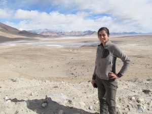
 Image courtesy of Solmaz Mohadjer.

Image courtesy of Solmaz Mohadjer.


  • You are: Solmaz Mohadjer
  • You work at: University of Tübingen
  • Your role is: First year PhD student


Q1) What are you currently working on?

I am currently learning to process and examine high resolution remote-sensing imagery from the Pamir region to more accurately locate, map, and categorize previously recognized (but poorly located) faults that are believed to be active.


Q2) What is a typical day like for you?

The truth is that often there is no typical day, and that’s probably a good thing. I try to start my day with a yoga and meditation session, and then treat myself to a good breakfast that can fuel my body and brain for the following activities (listed in no particular order): get the hang of the complicated (or awful as Mark Twain explains) German language, learning about the dynamics of tectonic and surface processes by attending courses at no charge (the awesomeness of attending a German university), obtaining, processing and examining satellite-imagery, looking for geomorphic markers, and discussing them with colleagues. I try to read a lot and learn at least one thing worth learning every day.


Q3) Could you provide a brief insight into the main findings of your research?

My colleagues and I have published a number of papers. Our most recent paper highlights GPS velocity measurements from the Pamir and Hindu Kush regions. These measurements are used to place bounds on present-day slip rates of several major faults and larger scale deformation. This information is useful for identifying or better quantifying regions of high strain with potential for large earthquakes. Other equally important outputs include communication of research results with those who need them the most. We have developed and implemented geohazards training workshops and seminars for school communities and various disaster risk reduction organizations working in the region.


Q4) What has been the highlight of your career so far?

My interest in studying natural hazards goes back to two events: flying over Mount Augustine to measure sulphur dioxide emitted from the volcano a week before it erupted, and backpacking in the Jammu and Kashmir region of India talking to Tibetan refugees about regional earthquake hazards a few days before the devastating 2005 Kashmir earthquake. I became motivated to study natural hazards and to share what I learn with at-risk communities. In 2011, I founded ParsQuake (www.parsquake.org) with a mission to raise levels of earthquake awareness, education, and preparedness of at-risk communities worldwide.


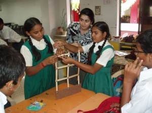
Solmaz during a public engagement activity at a school in Gujarat, India. School children are tought to build and test a wall model on a shake table as part of a  earthquake education workshop.  Image courtesy of Solmaz Mohadjer.

Solmaz during a public engagement activity at a school in Gujarat, India. School children are taught to build and test a wall model on a shake table as part of an earthquake education workshop.
Image courtesy of Solmaz Mohadjer.

Q5) To what locations has your research taken you and why?

Since the start of my PhD program (May 2013), I have visited the Lauterbrunnen valley in Switzerland to assist with operating a Light Detection and Ranging (LiDAR) laser scanner for collecting data that could help with locating and monitoring rock falls as well as understanding some of the triggering mechanisms. Prior to my PhD program, I worked as a geologist and a geohazard educator for various governmental and non-governmental organizations including humanitarian agencies in China, Afghanistan, Tajikistan, India, and Haiti.


Q6) Do you have one piece of advice for anyone wanting to have a career similar to yours?

Share your scientific data openly, freely, and creatively. One way to do this is to connect with organizations that can help you disseminate your findings with appropriate users in effective ways.


Q7) If you could invent an element, what would it be called and what would it do?

Contentium – A highly stable element that makes people more content and less bitter regardless of their circumstances.


Solmaz is a PhD student at the University of Tübingen in Germany where she applies remote sensing techniques to study the neotectonics and geodynamics of intracontinental mountain systems of Central Asia. Her research interests include tectonics, crustal deformation, and quantification of mountain hazards.  In addition to her research, she conducts geohazards education courses and professional development workshops for K-12 school communities and governmental and non-governmental organizations around the world to reduce disaster risk and increase resilience to natural hazards.