Between a Rock and a Hard Place

Mount St. Helens

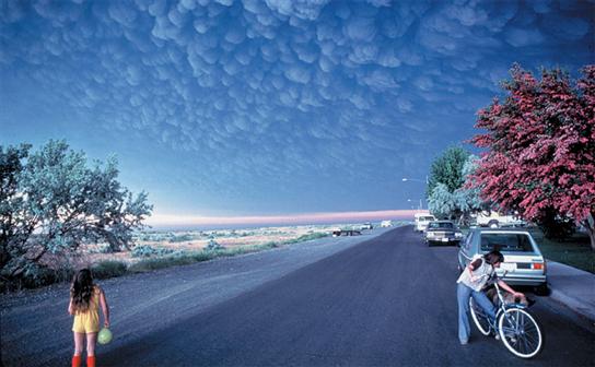
Science snap (#31): Mammatus clouds

After all the thunderous weather this weekend and being British, I thought I’d do a weather themed science snap. Don’t bolt yet; it’s a volcanic-weather themed!

Volcanic mammatus clouds forming after the eruption at Mount St. Helens. Copyright: Douglass Miller

Volcanic mammatus clouds forming after the eruption at Mount St. Helens. Copyright: Douglass Miller

This is a picture of mammatus clouds following the eruption of Mount St. Helens in 1980. These clouds are pretty rare, unusual and distinctive. Formally, the Glossary of Meteorology defines mammatus clouds as “hanging protuberances, like pouches, on the undersurface of a cloud”. The definition is aptly descriptive, but in essence mammatus are a series of bulges at the base of clouds, often under large thunderous cumulonimbus clouds. There are many different types of mammatus clouds, each with distinct properties and occurring under various cloud types, and mammatus in volcanic clouds is just one subcategory. There are relatively few documented occurrences of Mammatus under volcanic clouds. Apart from Mount St. Helen’s, they’ve been observed at during the eruption of Mount St. Augustine on 27–31 March 1986 and Mount Redoubt on 21 April 1990. No generally accepted formation for these mechanism exists, however it is clear that a sharp temperature gradient and a wind shear across the cloud-air boundary is needed to create these clouds. Did anyone spot Mammatus clouds in the UK this weekend?

Science Snap (10): The impact of eruptions

Mel Auker brings us our Science Snap this week…

Many people are aware of the May 1980 eruption of Mount St. Helens in Washington State, USA. Common photographs of the huge VEI 5 eruption show the large, billowing eruptive column rising into the stratosphere.

Less iconic are images of the destruction left behind, demonstrating the after-effects of the eruption. The US president at the time, Jimmy Carter, flew over St. Helens soon after and said the area looked “more desolate than a moonscape.” Now, more than 30 years on, the landscape still displays reminders of the awesome power of nature. Below are a selection of photographs taken in August 2011.

From top left, clockwise: 1. “Miner’s Car”, the remains of a car situated approximately 15 km from the volcano at the time of the eruption; 2. Trees flattened by the debris flow; 3. Tree trunks in Spirit Lake, approximately 8 km north of the volcano; 4. Hummocky avalance deposits. Credit: Melanie Auker

The top left photograph is of “Miner’s Car“, which has been left in place as a monument approximately 15 km NE of St. Helens. The heat of the eruption burnt all the exposed paint off the car, though the bumper (at the right of the image) is still largely undamaged. The top right photograph shows large trees flattened by the eruption, mantling the topography and identifying the direction of flow.

The bottom left photograph shows the huge number of tree trunks present in Spirit Lake, approximately 8 km north of St. Helens. As well as flattening trees, the eruption tore thousands from the ground which were deposited in the lake. The volume of material emplaced in the lake has reduced its surface elevation by over 60 m. The bottom right photograph depicts the rounded mounds (hummocks) that form part of the debris avalanche deposit to the north of the volcano. They are formed of relatively intact rocks that once formed the volcano’s summit.