Between a Rock and a Hard Place

Science snap

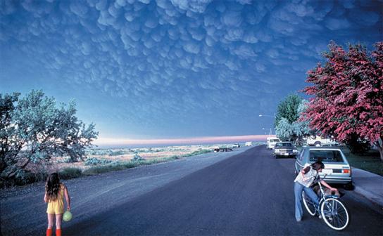
Science snap (#31): Mammatus clouds

After all the thunderous weather this weekend and being British, I thought I’d do a weather themed science snap. Don’t bolt yet; it’s a volcanic-weather themed!

Volcanic mammatus clouds forming after the eruption at Mount St. Helens. Copyright: Douglass Miller

Volcanic mammatus clouds forming after the eruption at Mount St. Helens. Copyright: Douglass Miller

This is a picture of mammatus clouds following the eruption of Mount St. Helens in 1980. These clouds are pretty rare, unusual and distinctive. Formally, the Glossary of Meteorology defines mammatus clouds as “hanging protuberances, like pouches, on the undersurface of a cloud”. The definition is aptly descriptive, but in essence mammatus are a series of bulges at the base of clouds, often under large thunderous cumulonimbus clouds. There are many different types of mammatus clouds, each with distinct properties and occurring under various cloud types, and mammatus in volcanic clouds is just one subcategory. There are relatively few documented occurrences of Mammatus under volcanic clouds. Apart from Mount St. Helen’s, they’ve been observed at during the eruption of Mount St. Augustine on 27–31 March 1986 and Mount Redoubt on 21 April 1990. No generally accepted formation for these mechanism exists, however it is clear that a sharp temperature gradient and a wind shear across the cloud-air boundary is needed to create these clouds. Did anyone spot Mammatus clouds in the UK this weekend?

Science snap (#30): Aust Cliff, Gloucestershire

One of the most fascinating things about geology is its ability to reveal global events from evidence contained within a single outcrop. The cliff exposure at Aust in Gloucestershire, UK, is a spectacularly colourful example of this.

Located beneath the original Severn Bridge, and running alongside the Severn Estuary, the 40m tall rock face records the drowning of an ancient desert by rising sea levels. In the Triassic, the SW of England sat 30ºN of the equator (the position of modern-day northern Africa). As the supercontinent Pangea rifted apart, the land was flooded by Jurassic oceans.

Aust cliff, near the Severn Bridge in south Gloucestershire. Photo credit: Charly Stamper

Aust cliff, near the Severn Bridge in south Gloucestershire. The change from red to grey-green in the rock strata records the flooding of an ancient desert by rising Jurassic seas. Photo credit: Charly Stamper

The red beds of the Triassic Mercia Mudstone group (~220 millions years old) form the base of the cliff, a geological archive of a time when this part of the UK was a hot, subterranean landscape. Rounded quartz grains with haematite coatings and accompanying veins of gypsum and celestine testify to an arid, windswept desert scattered with ephemeral lakes and playas.

The sudden change to the grey-green strata of the Blue Anchor formation is immediately evident to the eye. These clay-rich silty rocks contain halite crystals and provide evidence for the gradual ingress of inter-tidal lagoons and brackish lakes conditions.

Further sea level rise is charted by the Westbury formation (~205 million years old). The basal section comprises the famous Westbury Bone Bed, noted for yielding fossil insects, plesiosaur teeth and abundant bivalves; above this lies a layer of Cotham Marble, rich in stromatolites.

The Severn Bridge is easy to get to by bike – follow National Cycle Routes 4 and 41 from Bristol. Access to the cliff is via a steel gate to concrete causeway, at the bottom of the hill from Aust village.

The exposure at Aust is a SSSI; please only collect fossils from cliff debris and be careful of falling blocks close to the rock face.

Science Snap (#29): African Fairy Circles

Fairy Cirlces

Mysterious Fairy Circles dotting the Namibian grasslands. Credit: Neurgens


If you’re wandering among the arid desert that stretches from Angola to South Africa, you may notice the ground pot-marked by millions of circular barren patches. These striking features are known as “Fairy circles”, and can grow up to 15 meters in diameter. Tall grasses often surround these circles, further accentuating these miniature crop circles. How these Fairy Circles form is hotly debated. Theories have to account for their non-random location, and a lifespan 30-60 years where they grow in size borefore grassland eventually invades them again.

Oral myths of the Himba people attribute the circles to gods and spirits and traditionally they are thought to have spiritual and magical powers. My favourite myth, however, is that these Fairy Circles are scars in the landscape where a dragon breathed out toxic gases.

Unfortunately, a scientific explanation likely exists. In 2013, Juergens published an article supporting a popular theory that sand termites are responsible. The paper states that sand termites form the circles by eating grassroots to expose the soil. Once exposed, the soil more easily absorbs, which ultimately helps maintain the grasslands in extremely dry conditions. However, the sand termite theory has been critiqued for assuming correlation with causation, as Juergens suspects that termites are responsible because they’re the only species consistently observed at the circles. Thus, sand termites were identified by a process of species elimination.

In contention to the termite theory, Cramer and Barger (2013) believe that Fairy Circles are a consequence of natural competition in grasses. They suggest that landscapes with a mixture of grasses form “self organizing” circles due to underground competition for water resources. Both hypotheses have aspects that remain inconclusive, thus no theory currently prevails. They currently struggle to explain why circles appear across a variety of regions, soil and vegetation types and furthermore, no one has ever observed termites gnaw out a circle. Perhaps there is still room for a supernatural cause after all.

Namibian Fairy Cirlces

Namibian Fairy Circles. © 2013 Cramer, Barger. Published under Creative Commons License

Science Snap (#28): The Eye of the Sahara

Eye of the Sahara, Geology

The Eye of the Sahara. Image credit: NASA

Surrounded by thousands of square miles of ubiquitous desert, the “Eye of the Sahara” peers out from the Earth’s surface and at nearly 50 km wide, its easily visible from space too. The “Eye of the Sahara” is known as a Richat Structure, a geological feature consisting of a series of alternating circular layers of sedimentary, igneous and metamorphic rock, exposed by erosion.

The “Eye of the Sahara” is located in central Mauritiana and is also known as Guelb er Richat. The sheer size of the Eye meant it wasn’t discovered until space exploration took off. So here’s a challenge, find it on Google Earth.

The “Eye of the Sahara” was formed by a magmatic intrusion, which forced its way up and warped the overlying rock layers into a dome shape. The intrusion initially never reached the surface, but now erosion has effectively sliced dome’s top off, exposing its inner structure.

The Eye is extremely symmetrical, a striking feature that led scientists to interpret it as an impact crater. This idea was dismissed, however, when scientists began researching its structure. Nevertheless, scientists still can’t explain exactly why the Eye is so symmetrical.

The layers of rock inside the eye are visually distinct as each varies in colour, composition, and resistance to erosion. Inside the Eye there is a rich variety of geological rocks, including rhyolites, gabbros, carbonatites and kimberlites. Quartzite layers are highly resistant, but breccias and volcanic rocks are more prone to weathering and erosion. Intrusive kimberlite plugs beneath the Eye suggest the presence of deep and large alkaline magmatic intrusions and was likely responsible for uplifting the Eye.