EGU Blogs

What’s geology got to do with it?

What’s geology got to do with it? 5 – Scottish Independence Referendum

What’s geology got to do with it? 5 – Scottish Independence Referendum

Flo summarises 5 geo-relevant policy issues that are likely to impact on the Scottish Independence Referendum.

Sooooo apologies for the long blog holiday we’ve been on of late, Marion and I have had a fairly hectic summer, but fear not, we will be updating on a more regular basis from now on!

800px-Scottish_Flag

Source – Wikimedia Commons, Credit: Smooth_O.

Hitting the headlines in the UK this week is the impending referendum for Scottish Independence taking place on the 18th September. Latest polling suggests that the vote outcome is on a knife-edge. Either way, the build-up and inevitable political wrangling after the result undoubtedly means that the situation has changed for everyone, regardless of the outcome. One thing is for sure: the implications of an independent Scotland means big changes for both countries, the shape of which is still little understood and requires much discussion in the negotiation stages.

Taking a sidestep from the core politics for the moment, I’m going to have a brief look at 5 geology related topics in the run up to the referendum that could be affected, for better or worse depending on your point of view, by the decisions made next week!

This topic, like others with a geopolitical element, tells another interesting story about the link between the fortuitous geo-location of resources and the creation of nation states.

Fossil Fuel Reserves: The North Sea and Shale Gas

North Sea Licence

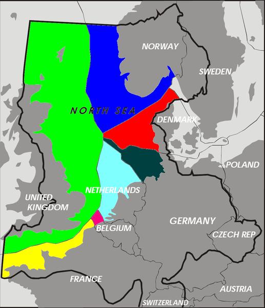
Exclusive economic zones for the North Sea, the green refers to the area covered by the UK Continental Shelf. Source – Wikimedia Commons, Credit: Inwind.

North Sea oil and gas has formed a significant proportion of revenue for the UK since the mid 60’s when the UK Continental Shelf Act came into force. Since then the UK government, via the UK continental shelf economic region, has controlled licensing of hydrocarbon extraction. This has been a particularly crucial source of revenue for the UK which peaked in 1999 with production of 950,000m3 (6 million barrels a day). In an independent Scotland, income from the remaining hydrocarbons in the North Sea would provide a considerable amount of revenue, but the rights over the North Sea, in the event of an independent Scotland are unclear, as it is yet to be negotiated. The majority of the confusion over this issue arises from the line in the North Sea that would demarcate Scottish territory. Many agree that this is likely to be drawn along the ‘median line’ or ‘equidistance principle’: a ‘line between the nearest points of land on either side using the baselines established around the coast of the UK in accordance with international law’ (from the UK Government’s Scotland Analysis: Borders and Citizenship). On this basis, Scotland’s share of the North Sea would be somewhere between 73-95% according to different sources. Further complications lie in the debate over the estimates of reserve remaining and whether it is more difficult to extract (geologists will be more than familiar with this sort of uncertainty!!).

North Sea oil and gas fields distribution. Source - Wikimedia Commons.

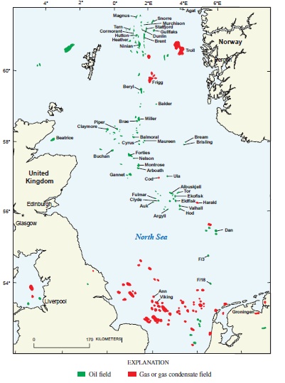
North Sea oil and gas fields distribution. Source – Wikimedia Commons, Credit: Gautier, D.L .

A fact check produced by Channel 4 earlier this year cast doubt on the values of remaining reserves. These unknowns have made confident and informed arguments on this topic difficult for both sides. This may not be critical, however, as leaving the North Sea out of the Scottish economy completely, it is still a thriving economy: only slightly smaller than that of the UK.

Another issue that has been discussed in the run up to the Scottish independence referendum is Scotland’s shale gas reserves and the issue of fracking. A report published just last week by the N56 business body claimed that fracking of what would be Scotland’s oil and gas reserves could almost double the amount recoverable from oil and gas in the North Sea, the target being the Kimmeridge Bay formation, an Upper Jurassic organic rich shale which is the major oil and gas source rock for the Central and Northern North Sea. The BGS has since debunked this estimate stating that there is only “a modest amount” of shale gas and oil reserves

There is a more detailed discussion of these issues on Carbon Brief’s blog

Climate Change and Renewable Energy

Wether_Hill_wind_farm_-_geograph.org.uk_-_414459

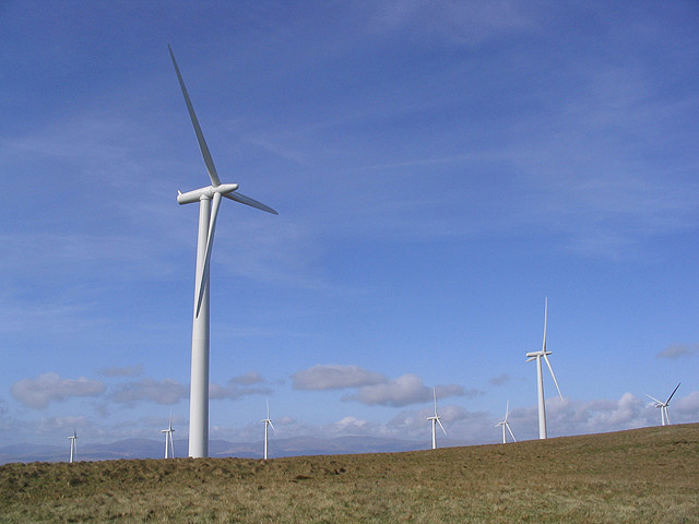
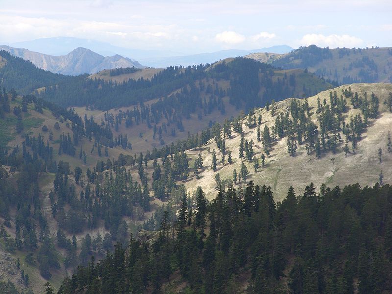
Wether Hill, Dumfries and Galloway wind farm. Source – Wikimedia Commons, Credit: Walter Baxter.

Scotland has some pretty impressive environmental credentials when it comes to renewable energy, a staggering 69% of Scotland’s electricity was generated from a combination of renewables (29.8%) and nuclear (34.4%) in 2012. Scotland has a massive renewable resource and the Scottish National Party (SNP) have been vocal in stating that they want to make Scotland the green capital of Europe. The Yes campaign website states that ‘Scotland is on target to meet all of its electricity needs, and 11% of its heat requirements, from renewable sources such as wind, wave, tidal, solar and biomass by 2020′. As it stands, control over energy policy and funding resides with Westminster. The Scottish Government has shown a commitment to low-carbon energy sources in its 2009 paper which introduced ambitious plans to reduce emissions by at least 80% by 2050.

Carbon Capture and Storage

798px-Peterhead_Power_Station_from_Boddam

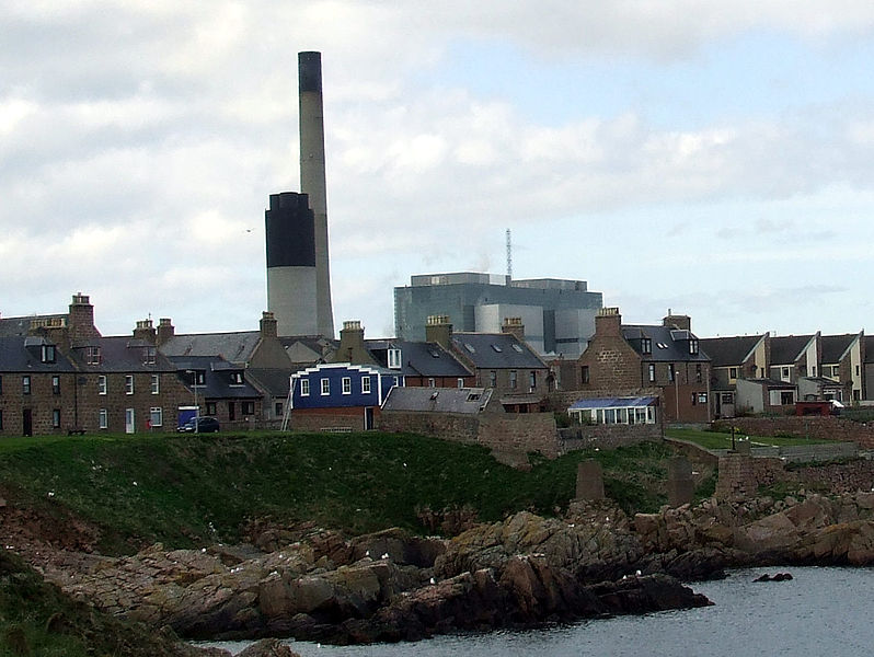
Peterhead Power Station, Site of DECC CCS funding. Source – Wikimedia Commons, Credit: PortHenry.

After some very slow progress in the DECC CCS competition (see my earlier post on this), the shortlist (not even the final selection) was eventually announced last year with two shortlisted sites, one of which is the Peterhead Project off the coast of Aberdeenshire, which has been awarded a funded contract to undertake front-end engineering and design studies. The Peterhead Project may well have an uncertain future if the referendum turns out a ‘Yes’ result. Energy Secretary Ed Davey admitted that the progress of the Peterhead CCS plant would be significantly trickier in the event of independence. While the Yes campaign has outlined its low-carbon credentials, a future Independent Scotland may find it hard to justify funding the very expensive CCS scheme alone. We could, however, end up in a situation where rUK (rest of the UK – the successor state in the event of Scottish independence) projects send their CO2 to storage sites in the North Sea, the revenues of which would go to an independent Scotland. This would mean that Scotland could still benefit from CCS development even if development at Peterhead is cancelled.

Research and Science Funding

OLYMPUS DIGITAL CAMERA

Grant Institute, School of Geosciences, Edinburgh University. Source – Wikimedia Commons, Credit: Kay Williams.

Much has been written about the future of science research and  funding in the event of a Yes vote at the referendum. Some groups of scientists have come out to say that a Yes for independence could damage the country’s research base and hurt the economy, this was stated most recently by the presidents of the Royal Society, the British Academy and the Academy of Medical Sciences. In contrast, the ‘Academics for Yes‘ group states that Scottish independence will secure and enhance the international profile of Scottish universities and also boost work between the research sector and the government to develop Scotland’s economy, as well as giving them control of research priorities. A piece posted just this week in Nature showed that opinion is split with regards to the impact of independence on science research and funding, with some touting improved innovation under independence and others saying that the border would hinder the open exchanges under which science thrives.

Radioactive Waste Disposal

800px-Dounreay_Nuclear_Power_Development_Establishment_geograph-3484137-by-Ben-Brooksbank (1)

Dounreay nuclear power development, Caithness. Source – Wikimedia Commons, Credit: Ben Brooksbank.

The Scottish Government’s energy policies, in contrast to Westminster, favour renewable energy as well as use of North Sea Oil and Gas over what is described as ‘risky’ nuclear power and their policies for radioactive waste disposal also differ from that of Westminster. While Scotland has stated that it won’t be developing new-nuclear power it has an extensive history of nuclear power generation which has its own legacy waste associated with it.  The Scottish Government, unlike the UK Government, has stated it will not use geological disposal as a method of waste storage and their policy is that waste should be stored in near-surface facilities and recognises that ‘long-term management options may not be feasible at present or have yet to be developed‘.  A recent academic paper on this issue suggested the following: 

‘In an independent or further devolved Scotland the task of building the necessary installations for nuclear waste disposal will be a significant cost to a new nation. However, there is also a lack of a legal framework, and this should be addressed with immediate effect.’

Additional confusion with regards to radioactive waste policy arises from the difference between ‘spent fuel’ and waste. Spent fuel is defined by the US Nuclear Regulatory Commission as:

the bundles of uranium pellets encased in metal rods that have been used to power a nuclear reactor. Nuclear fuel loses efficiency over time and periodically, about 1/3 of the fuel assemblies in a reactor must be replaced. The nuclear reaction is stopped before the spent fuel is removed. But spent fuel still produces a lot of radiation and heat that must be managed to protect workers, the environment and the public.

Spent fuel is not currently classified as waste, and therefore can be traded and sent overseas for processing, whereas this is banned for material classified as ‘waste’. Currently, the Thorp Reprocessing plant at Sellafield accepts spent fuel contracts from around the world (including Scotland), that would include an independent Scotland. However, the Thorp plant is due to close in 2018 when current contracts have been completed. This may create an issue with any remaining spent fuel in the UK, regardless of an independent Scotland. However, if either an independent Scotland or the remaining UK decided to reclassify ‘spent fuel’ as waste, this would remove the option to export waste for processing and would require an independent Scotland to develop additional infrastructure to deal with this new waste.

Further Reading

What’s geology got to do with it? 4 – Tennis!

What’s geology got to do with it? 4 – Tennis!

 As part of the ‘What’s geology got to do with it?’ series, Flo takes us on a tour of the links between geology and tennis! Warning: You may not want to read this if you have no interest in Geology OR tennis…. 

Now the disclaimer’s out of the way, I thought it was about time I married two of my greatest loves in life, Geology and Tennis. These two interests may seem completely at odds in terms of relevance, but as is the beauty with geology, it relates to just about everything!

So, summer in the northern hemisphere and therefore the two biggest Grand Slams in tennis are upon us!  The French Open, the king of the clay-court season is currently underway and Wimbledon, the jewel (and one of the few remaning…) grass court tennis tournaments is just around the corner.

But for a sport containing so few tangible objects: a court, a racket, a person and a tennis ball, how does it relate to Geology? Well….

Tennis Courts

491px-ND_DN_2006FO

Court Philippe Chatrier Court at the French Open, the only Grand Slam played on red clay. Source – Wikimedia Commons

Professional tennis is  played on 3 types of court surface, each with its own season during the tennis calendar.  You have the hard court season, which dominates most of the year between July and February, beloved by Djokovic, then you have the European and North and South American clay court season from February to May, favourite of clay-court extroadinaire Rafa Nadal and then the shortest season of all, the grass court season, occupying all of 4 weeks in the summer, from June-July, once dominated by Federer and recently by Murray! The most obvious link to geology here is the clay courts, so how do you go about building a clay court and what materials do you need?

Red Clay Courts

Well first of all, very few clay courts are actually made of natural clay. This is because they can take a very long time to dry out (which you’ll know if you’ve ever done any pottery….). For this reason, the red clay courts as seen at the French Open and numerous other clay court tournaments are actually made from crushed brick or shale. Bricks are used because they absorb water less easily than natural clay and are produced from a mix made from Alumina (clay), sand, lime and iron oxide before being fired until dry.


guga-kuerten-trophy-frenchopen08

Guga Kuerten being awarded a cross-section of the court in his last match at the French Open in 2008. Source – Tennis Served Fresh Blog

So if you want to build a clay court like the famous red-clay courts of the French Open, first of all you need to lay a base layer, this is covered with a layer of crushed stones, this is then overlain by a layer of clinker. This is then followed by a layer of crushed limestone and finally, the crushed brick forms the thinnest layer at the top. A cross section of the layering under the court surface formed the trophy that former French Open champion Guga Kuerten received when he played his last match at the tournament in 2008!

800px-Drying_mud_with_120_degree_cracks,_Sicily

You wouldn’t want the Philippe Chatrier court looking like this after a few hours of sunshine! Source – Wikimedia Commons.

Maintenance of the court after completion is a bit tricky as the clay needs to be constantly smoothed and watered in order to prevent dewatering cracks, a feature that many geologists are very familiar with!

Green Clay Courts
800px-Maria_Sharapova,_2008_Family_Circle_Cup

Maria Sharapova playing on the ‘green clay’ at the Family Circle Cup. Source – Wikimedia Commons

Not all tournaments use red clay, so called ‘green’ clay’ or ‘Har-Tru’ has become very popular in the United States. Har-Tru courts are similar in construction but are made from crushed basalt rather than brick meaning they are slightly harder and faster. According to their website, Har-Tru courts are made from ‘billion-year old Pre-Cambrian metabasalt found in the Blue Ridge Mountains of Virginia‘. This rock has two important properties, which is that it is hard and angular which allows it to ‘lock together to form a stable playing surface’ and the hardness provides ‘exceptional durability’.

Tennis rackets

800px-Tennis_Racket_and_Balls

A modern tennis racket with a carbon fiber-reinforced polymer frame. Source – Wikipedia Commons

As with many manufactured items, the raw materials required to make them eventually leads us back to our natural resources in the ground. Earlier tennis rackets were always made from wood, with strings made from gut, but these days, advancements in materials technology means that the majority of professional frames are made from ‘high modulus graphite and/or carbon fibre while titanium and tungsten are often added to give the frame more stiffness and the strings are made from nylon (although Federer and Sampras are famous for using natural gut strings).

Supplies of pure titanium are rare although titanium ores such as ilmenite and rutile are much more common. Titanium is largely mined in the titanium-rich sands of Florida and Virginia as well as Russia, Japan, Kazakhstan and other nations. Much more rare is Tungsten, which has seen a rapid rise in price in recent years as supplies dwindle. Tungsten has recently emerged as a ‘critical’ metal with the majority of the world’s tungsten supply located in China. However Hemerdon mine  in Devon which has been closed since 1944, is thought to host one of the largest tungsten and tin deposits in the world, and is set to reopen under control of an Australian firm in the near future with permit plans progressing this year.

For more on how a tennis racket is made: http://www.madehow.com/Volume-3/Tennis-Racket.html

Tennis Balls

427px-Tennis_balls,_advertisement,_19th_century

Tennis ball advertisment, 19th century. Source – Wikimedia Commons

According to an article in the guardian published in 2013, manufacture of Slazenger tennis balls now has a 50,000 mile production journey before they end up in Centre Court at Wimbledon. Part of this journey includes the transport of various mineral resources. These include the transport of clay from the United States,  Petroleum Napthalene (derived from coal tar) from China, Sulphur from South Korea, Magnesium Carbonate from Japan, Silica from Greece and Zinc Oxide from Thailand. This exemplifies not just the truly global nature of the manufacturing markets but also the complex importing and exporting of many natural resources for something as simple as a tennis ball.

For more on how tennis balls are made, see the ITF website: http://www.itftennis.com/technical/balls/other/manufacture.aspx


Tennis Net

courtmaster-net

Anatomy of a tennis net. Source – Do it tennis website.

The majority of the different parts of a tennis net are made up from either polyester or polyethylene, both formed synthetically. However, the raw materials required to synthesise both materials  started off as extracted hydrocarbons. Polyester synthesis requires the polymerisation of ethylene which is derived from petroleum.

60 million tonnes of polyethylene is manufactured each year and is the world’s most important plastic. It is made by several methods by addition polymerisation of ethene, which is principally produced by the cracking of ethane and propane, naptha and gas oil, all hydrocarbon fractions. In Brazil, a plant is being constructed to make polyethylene from sugar cane via bioethanol.


And that’s how geology underpins everything we know and love about tennis!


For more information on the link between sports and geology, see the United States Geological Survey’s article on ‘Minerals in Sports: Tennis’: http://minerals.usgs.gov/minerals/pubs/general_interest/sport_mins/tennis.pdf

What’s Geology got to do with it? 3 – Christmas! Part 1

What’s Geology got to do with it? 3 – Christmas! Part 1

Dear Readers!

Christmas is almost upon us and so at Four Degrees we decided to devote our next post in the ‘What’s Geology got to do with it?’ series to Christmas! Marion and I have selected varying aspects of the festive season from trees to biblical stories and common Christmas presents, and linked them to geology (some tenuous, some not so tenuous…). We hope you enjoy!

The Journey to Bethlehem

The story of Joseph and Mary’s hallowed journey from Nazareth to Bethlehem is an intrinsic part of christmas festivities. But what route did they take and what landscapes would they have seen?

715px-1759_map_Holy_Land_and_12_Tribes

Map of the Holy Land showing the Old Kingdoms of Judea and Israel drawn in 1759. Source – Wikimedia Commons

As a distinct geographic area, the description “Holy Land” encompasses modern-day Israel, the Palestinian territories, Jordan and sometimes Syria. The geology of the Holy Land is characterised by the Judean Hills which run North to South through the centre of the region exposing Cretaceous age limestones and sandstones. The rocks reach down to the western banks of the Dead Sea and the Jordan Valley Rift valley which marks the modern border between Palestine and Jordan. The Judean Hills mark the highest area in the region (an area Joseph and Mary may have been trying to avoid!) and the topography then lowers to the Mediterranean coast to the west and the Dead Sea to the east.

Joseph and Mary’s journey to Bethlehem began in Nazareth in modern day Israel and ended in a manger in Bethlehem, which is in modern day Palestine. The route taken between the two, and indeed the time it took them is oft disputed. Given the mountainous nature of the central Holyland which is dominated by the Judean Hills and the reality of transporting a pregnant woman on a donkey, it is possible they would have avoided the mountains and travelled southeast across the Jezreel Valley, connecting with the Jordan Valley to the East, down to Jericho and then across to Bethlehem. This route would have looked something like this.

Image of the Judean Hill taken in 1917. Source – Wikimedia Commons

The area they may have wanted to avoid, the Judean Hills, is formed from monoclinic folds and relates to the Syrian Arc belt of anticlinal folding in the region that began in the Late Cretaceous.  These are the same hills that include the famous Mount of Olives, and the location of the story of David and Goliath which occurred in the Ella Valley in the Judean Hills’. It is also home to Bethlehem which stands at an elevation of about 775 meters and is situated on the southern portion in the Judean Hills.

By contrast, the Jordan valley encompasses the lowest point in the world, the Dead Sea (sitting at 420 below sea level). The valley was formed in the Miocene (23.8 – 5.3 Myr) when the Arabian tectonic plate moved away from Africa.  The plate boundary which extends through the valley (and houses the Dead Sea!) is called the Dead Sea Transform. This boundary separates the Arabian plate from the African plate. For more on the geology of the Dead Sea region see this earlier Four Degrees post.


Lego

398px-Lego_Christmas_Tree_at_St_Pancras_International

Christmas tree made of Lego at St Pancras Station! Source – Wikimedia Commons

As children (or adults!) many of us will have experienced unwrapping various Lego sets on Christmas Day. Its popularity has been sustained over the last 50-60 years whilst the company has continued to grow; Lego never goes out of style! But did you know that Lego has been manufacturing its hugely successful interlocking toy bricks since 1949 and as of 2013, 560 billion Lego parts have been produced! But what does any of this have to do with geology?

220px-Lego_Color_Bricks

Lego blocks! Source – Wikimedia Commons

Well, Lego started off as wooden blocks and toys in the workshop of inventor Ole Kirk Christiansen, before moving onto manufacuring the blocks out of cellulose acetate. But since 1963 the blocks have been made from a resilient plastic called acrylonitrile butadiene styrene (ABS).  As with many plastics, the Butadiene and Styrene components of ABS are formed from a process that begins with the extraction and cracking of crude oil. Oil consists of a mixture of hundreds of different hydrocarbons containing any number of carbon atoms from 1-100. Butadiene is a petroleum hydrocarbon that is obtained from the C4 fraction of steam cracking (more on steam cracking here ) and styrene is made by the dehydrogenation of ethylbenzene, a hydrocarbon obtained in the reaction of ethylene and benzene. Lego is just another manufactured product who’s journey began in the rocks!

Wrapping Paper

Christmas_wrapping_paper_display

Christmas wrapping paper! Source – Wikimedia Commons

The use of wrapping paper was first documented in ancient China where it was invented in 2nd century BC but it was the innovations of Rollie and Joyce Hall, the founders of Hallmark Cards that helped popularise the idea of wrapping in the 20th Century. Wrapping paper is made using specially milled wood pulp, this pulp is made from a special class of trees called softwoods. The paper is then bleached and decoration and colours are printed onto the paper using dyes and pigments.

Whilst many dyes that are used in the modern day are synthetic, originally all dye materials were sourced from natural materials. Here we focus on how to make the dyes and pigments for christmassy colours!

800px-Alizarin-sample

Powdered Alizarin dye. Source – Wikimedia Commons

There are a variety of natural materials that can be used to make red dyes including lichen, henna and Madder. Madder, made from the dye plant Rubia tinctorum, has been used as a dye as far back as 1500BC it was even found in the tomb of Tutankhamun. Madder was also used to make Alizarin, the compound 1,2-dihydroxy-9,10-anthracenedione. Alizarin was a prominent red dye until synthetic Alizarin was successfully duplicated in 1869 when German chemists Carl Graebe and Carl Liebermann found a way to produce alizarin from anthracene. A later discovery that anthracene could be abstracted from coal tar further advanced the importance and affordability of alizarin as a synthetic dye. This reduced cost caused the market for madder to collapse almost overnight. While alizarin has been largely replaced by more light-resistant pigmens it is still used in some printing.  (QI – it is also used in classrooms as a stain to indicate the calcium carbonate minerals, calcite and aragonite!)

Other more exotic inks and pigments used in wrapping paper such as metallic pigments are also made through mined raw materials. To produce metallic pigments, materials such as Aluminium powder (aluminium bronze) and copper-zinc alloy powder (gold bronze) are used to produce novel silver and gold inks!


Christmas Trees

800px-Julgransförsäljning_utanför_Lunds_domkyrka

Abies Nordmanniana on sale as christmas trees. Source – Wikimedia Commons

Christmas trees are an iconic part of Christmas, whether at home or in your local area its hard to go far in December without seeing one most days! In fact they are so popular now that Christmas trees are farmed specifically for this purpose. While the best selling trees in North America are Scots Pine, Douglas-fir and noble fir, in the UK, Nordmann fir is the most popular species due to its low needle drop feature.

As with all crops, Christmas trees require a specific set of nutrients to thrive and these are provided by fertile soil which is controlled by the underlying geology. Elements that are required for health growth include Nitrogen, Phosphorus, Potassium, Calcium, Magnesium, Sulphur, Boron, Copper, Manganese, Molybdenum, Iron and Zinc which are all obtained from the soil.

Where this isn’t available or in areas of intensive farming these elements are derived through the use of fertiliser which relies on mined phosphate for mass production (more on the link between fertiliser and mined phosphate reserves here). In terms of soil types, pine trees are usually better adapted to a sandy or sandy loam soil, while White Spruce trees and fir trees,  prefer fine-texture loams and clay loam soils.

800px-Abies_nordmanniana_@Kurtbeli-Alucra-Giresun

Abies nordmanniana trees located in the Black Sea region of Turkey. Source – Wikimedia Commons

The popular Nordmann fir used in the UK, or ‘Abies nordmanniana’ is native to the mountains to the east and west of the Black Sea in an area which covers Turkey, Georgia, Russian Caucasus and Armenia. They grow at high altitudes of 900-2200 m on mountains and require plenty of rainfall (~1000mm).

The distribution of the species around the Black Sea and its absence in other local areas of similar, suitable climate is thought to be due to the forest refugia that formed during the ice age. Refugia is the term used to describe a location of an isolated or relict species population. This can be due to climatic changes, as with Nordmann Fir, geography (and therefore geology) or human activities such as deforestation. The forest refugia that caused the limited spread of the Nordmann Fir was caused by the glacial coverage during the Ice Age in the eastern and southern black sea which cut off many areas restricting the spread of the species. Indeed the presence of these refugia is the reason many forest tree populations survived at all!


Stay tuned for Marion’s Part 2 of the Christmas Post next week…

Flo

What’s Geology got to do with it? 2 – Coffee

We should start this post with a declaration of interest. We absolutely love coffee. Whether it’s  latte, macchiato, flat white (or cafe au lait for Marion!) we drink it everyday! So for our second installation of “What’s geology got to do with it?’ we’re going to highlight the connections between coffee and geology!

fpVcA2_imgur

Coop loves his coffee! Source

As well as being absolutely delicious (and often powering an entire community of researchers, PhD Students, lawyers etc through work on a daily basis!) coffee is the 2nd most traded commodity in the world, sitting in a list dominated by other commodities important to geoscience!

  1. Crude Oil
  2. Coffee
  3. Cotton
  4. Wheat
  5. Corn
  6. Sugar
  7. Silver
  8. Copper
  9. Gold
  10. Natural Gas

Coffee and Soils!

800px-CoffeeCatucai

Coffee berries, a variety of Coffeea Arabica. Source – Marcelo Corrêa, Wikimedia Commons.

In order to supply the international demand for coffee, coffee trees require a large supply of nutrients. These nutrients are delivered through soils which are ultimately formed from the breakdown and erosion of rocks. In addition to allowing coffee trees to grow, the soil makeup will also contribute to a coffee’s unique flavour profile. Having said that, the combination of factors affecting taste is so complex, that even from a single plantation you can find variation in quality and taste.

What does coffee need to grow?

Aside from cool-ish temperatures (~20 degrees) and high altitude (1000-2000 metres above sea level), Coffee requires a wide variety of essential elements in order to grow and deliver the delicious stuff we drink. These elements are delivered through the soil profile. The usual suspects like Phosphorus, nitrogen, potassium, calcium, zinc and boron are all very important. The level of potassium influences total sugar and citric acid content while nitrogen is important for amino acid and protein buildup and can influence caffeine build up. Boron is important for cell division, cell walls and involved in several enzyme activities. It also influences flowering and fruit set and affects the yield. In addition to soil type and content, factors such as slope angle (15% is optimal), water supply (good supply with interspersed dry periods are essential) and altitude exert strong influence on the success of coffee growth.

What soils are best?

Coffee can be grown on lots of soils but the ideal types are fertile volcanic red earth or deep sandy loam. For coffee trees to grow it is important that the soil is well draining which makes heavy clay or heavy sandy soils inadequate. Some of the most longstanding and famous coffees are grown on the slopes of volcanoes or in volcanic soil, also known as ‘Andisols’.

Definition of Andisol (USDA soil taxonomy) – ‘Andisols are soils formed in volcanic ash and defined as soils containing high proportions of glass and amorphous colloidal materials, including allophane, imogolite and ferrihydrite.’

102 SSC2_No_Folder _33R

Coffee grows on the slopes of these volcanoes in El Salvador. Source – NASA, Wikimedia Commons

But why are they so fertile? This is due to how young, or immature they are as soils. They still retain many of the elements that were present during the formation of the rock, they haven’t been plundered over hundreds of years of agriculture, they haven’t undergone extensive leaching and are relatively unweathered. This means they often include basic cations such as Mg, Ca or K (which can be easily leached out) and often retain a healthy supply of trace elements. Whilst these soils are very fertile, they only cover around 1% of the ice-free surface area of the earth. They can usually support intensive use for growing coffee and other mass crops such as maize, tea and tobacco. Despite the high fertility of volcanic soils, many do need a nutrient top-up during the growth cycle that comes from natural manure or fertilisers, which are themselves in diminishing supply.

Volcanic soils also have a good structure and texture for coffee growth as they often contain vesicles, which makes them porous and ideal for retaining water. Shallow groundwater is bad for coffee growing as it can rot the roots and it needs to be at least 3 metres deep. Roots of coffee have a high oxygen demand so good drainage is essential.

Where does coffee grow and why?

It is no surpise then that some of the most famous and historic coffee growing regions are in areas of past and current volcanic activity such as Central America, Hawaii and Indonesia. Coffee trees produce their best beans when grown at high altitudes in a tropical climate where there is rich soil. Such conditions are found around the world in locations along the Equatorial zone.
Coffee is grown in more than 50 countries around the world including the following;

  • Hawaii – coffee is grown in volcanic soil or directly in the loosened rock. The location and island climate provides good growing conditions. 

    GT056-Antigua_Arch-low.jpeg

    Volcán de Agua overlooking Antigua in Guatemala an area with a big coffee production industry. Source – Zack Clark, Wikimedia Commons.

  • Indonesia – coffee production began with the Dutch colonialists and the highland plateau between the volcanoes of Batukaru and Agung is the main coffee growing area. Ash from these volcanoes has created especially fertile andisols.
  • Colombia – thought that Jesuits first brought coffee seeds to South America. One of the biggest producers in the world, regional climate change associated with global warming has caused Colombian coffee production to decline since 2006. Much of the coffee is grown in the cordilleras (mountain ranges).
  • Ethiopia – grown in high mountain ranges in cloud forests.
  • Central America – rich soils along the volcanic range through central america, equatorial temperatures and mountainous growing areas make this a powerhouse in the coffee growing world. 

Coffee and Climate!

Like many crops and food commodities, good coffee requires good climate. For our favorite bean, this typically means temperate regions  at altitudes of 1000-2000 m. But climate is changing and this is likely to have a big impact on coffee growth, and by association, on the livelihood of millions of local coffee farmers who rely on its production.

In its latest report out last month, the UN’s Intergovernmental Panel on Climate Change (IPCC, the leading  body assessing climate change impacts) confirmed for the 5th time what climate scientists worldwide already know: that our climate is warming as a result of human activities. Global temperatures have already risen by almost 1C since the end of the 19th century and will continue to rise at even faster rates over the coming century.

There are two ways in which a changing climate will impact coffee growth and production.

First, increasing temperatures or changes in precipitation will directly affect the areas suitable for coffee growth, leading to a loss in coffee growing environments.

A coffee berry being chewed up by hungry Hypothenemus hampei - Source: L. Shyamal, Wikimedia Commons.

A coffee berry being chewed up by hungry Hypothenemus hampei – Source: L. Shyamal, Wikimedia Commons.

Second, and perhaps most importantly, changing climate and higher temperatures will affect a little insect called Hypothenemus hampei (H. hampei for short). H. hampei is small but lethal. This beetle-like insect is what people call a coffee berry borer. It is the most important threat to coffee plantations worldwide.

Born in central Africa, H. hampei began colonising coffee plantations worldwide with the global movement and commerce of coffee beans. H. hampei likes warm climates. Until about a decade ago, it was very happy munching away at low-altitude beans, below the preferred altitude of our beloved Arabica coffee (between 1200-2000 m in East Africa).

But with rising temperatures, the berry borer can now survive at higher altitudes. On the slopes of Mt Kilimanjaro in Tanzania, H. hampei has climbed 300 m in 10 years.

Mount Kilimanjaro - Source: Muhammad Mahdi Karim, Wikimedia Commons.

Mount Kilimanjaro – Source: Muhammad Mahdi Karim, Wikimedia Commons.

H. hampei causes over $500 million loss annually in East Africa alone. The borer is gaining both geographical extent (it is only absent from coffee plantations in China and Nepal, having infiltrated Puerto Rico in 2007 and Hawaii in 2010) and altitude. A further 1C increase will see the borer develop faster and gain new territories.

The Colombia coffee belt - Source:  Instituto Geografico Agustin Codazzi, Wikimedia Commons.

The Colombia coffee belt – Source: Instituto Geografico Agustin Codazzi, Wikimedia Commons.

In Colombia, where coffee accounts for 17% of the total value of crop production, temperatures in the coffee belt region are projected to rise by 2.2C by 2050. This could both shorten the coffee growing season and allow  the pest to make its way above 1500 m.

It has been estimated that Colombian plantations would have to be moved up by 167 m for every degree of warming.

In East Africa, studies predict that Arabica coffee, currently grown at 1400-1600 m,  will have to shift to 1600-1800 m by 2050 as a result of rising temperatures.

But it is unlikely that East African coffee plantations will be able to adapt. For one, suitable high altitude habitats are not common. Second, population growth is likely to put a huge demographic pressure on arable land (the population in Ethiopia is set to double by 2050 – see this fact sheet by the Population Reference Bureau) and it is likely that the shrinking available arable land will be used to cultivate other crops over coffee.

The impact of climate change on invasive pest species is something that ecologists are studying worldwide. Small changes in average temperatures can have huge bearings on where these pests live and what they feed on, and this seems to already be the case for the coffee berry borer.

Let’s hope Flo and I can continue enjoying our weekly Four Degrees coffee meetings for many years to come!

Flo and Marion