This week’s post is brought to you by Stefan Winkler, a Senior Lecturer in Quaternary Geology & Palaeoclimatology, who explains how the mountain tops of the Southern Alps become decorated by beautiful blanket-like cloud formations. The Sothern Alps of New Zealand are a geoscientifically dynamic environment in all aspects. They are arguably one of the youngest high mountain ranges in the ...[Read More]
Imaggeo on Mondays: The largest fresh water lake in world
Most lakes in the Northern hemisphere are formed through the erosive power of glaciers during the last Ice Age; but not all. Lake Baikal is pretty unique. For starters, it is the deepest fresh water lake in the world. This means it is the largest by volume too, holding a whopping 23,615.39 cubic kilometres of water. Its surface area isn’t quite so impressive, as it ranks as the 7th largest in the ...[Read More]
Imaggeo on Mondays: An explosive cloud
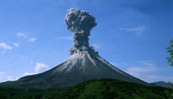
Karymsky volcano, 2004. Credit: Alexander Belousov (distributed via imaggeo.egu.eu)
One of the world’s most volcanically active regions is the Kamchatka Peninsula in eastern Russia. It is the subduction of the Pacific Plate under the Okhotsk microplate (belonging to the large North America Plate) which drives the volcanic and seismic hazard in this remote area. The surface expression of the subduction zone is the 2100 km long Kuril-Kamchatka volcanic arc: a chain of volcanic isla ...[Read More]
Imaggeo on Mondays: Landslide on the Cantabrian coastline
Shimmering blue seas, rocky outcrops and lush green hills sides; this idyllic landscape is punctuated by a stark reminder that geohazards are all around us. Irene Pérez Cáceres, a PhD student at the University of Granada (Spain) explains the geomorphology behind this small scale landslide on the Asturian coastline. This picture was taken in May 2011 in the coast of Llanes (Asturias, Spain). I was ...[Read More]