At 3:34 a.m. (local time) on February 27, 2010, a magnitude Mw 8.8 earthquake occurred in Central Chile and extended over around 500 km along the Maule and Bio Bio regions, a convergent zone between the Nazca and South America plates (Figure 1a).
The occurrence of this large earthquake in the context of active subduction zones, as Central Chile, was expected by many Chilean and European researchers who analyzed the GPS measurements between 1996-2002 and discovered that the plate interface was completely locked (Ruegg et al., 2009). A seismic study was not possible because of the lack of seismometers in the area but between 2000 and 2009 only ten earthquakes magnitude greater than 5.0 occurred in the zone.
The last experience of a major subduction earthquake was in 1835, the so-called Darwin’s earthquake, historically known as a magnitude 8-8.5 (Madariaga et al., 2010), which was described with coastal uplift, tsunami inundation and material damages in villages and cities nearby.

Figure 1. a) Slip distribution model by Yue et al. (2014), showing the two main asperities with a maximum slip above to 10 m close to the trench, b) Tsunami heights reported by Fritz et al. (2013) along with the coastal areas of Central Chile.
Human and economic costs
In 2010, the Mw 8.8 earthquake produced substantial damage, loss of life and economic losses estimated in USD$ 30 billion, approximately 18% of the GDP of Chile. The official number of victims was about 530 fatalities with a quarter of them attributed to the great tsunami inundation.
The tsunami destroyed and spanked the coastal areas, with at least four great sea-waves during the hours following the mainshock with maximum run-ups of 29 meters in front of Constitución, and 20 meters in Tirúa, both in the extreme zones of the main rupture (Figure 1b, Fritz et al., 2013).
Tirúa is a poor city of artisanal fishermen and half of the indigenous people. Here, the impact of the tsunami wave was one of the most violent, where some houses were found about 1 km from their original position. Most of the buildings and the public facilities disappeared but, surprisingly, no victims were reported.
But why were there no dead?
Oral tradition
The ancestral tradition prevailed among the indigenous people, the Mapuches, which literally means “People of the Land”.
Despite the continuous dispossession of their lands and their own beliefs in the last 500 yrs, there are many aspects of this culture that have been passed on until today: the oral tradition, telling stories and maintaining ceremonies in connection with nature.
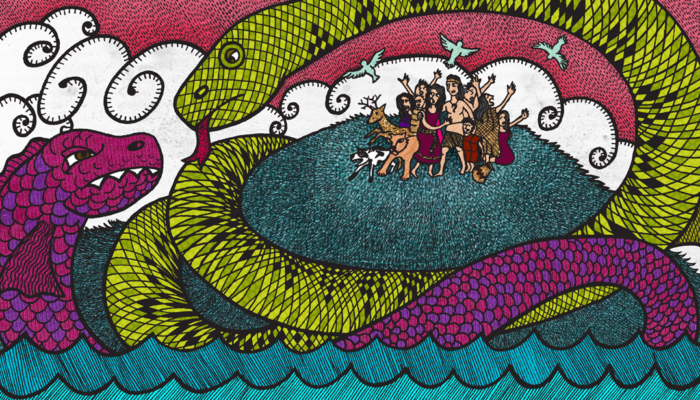
That ancestral knowledge told us about two snakes that faced each other, about Cai Cai Vilu, a sea snake that punished people and raised the sea level, but there was also Tren Tren Vilu, a snake that lives in the hills and that elevates them to protect people (Figure 2).

Figure 2. The snake of the sea named Cai Cai, and the snake over the earth named Tren Tren. Source: https://chilotemyth.com/
This story, in the Chilean collective unconscious, allowed many people who could not stand up on their own after the strong earthquake to find shelter up the hills. They were aware that the tsunami was imminent, especially in Chile, where the short distance between the earthquake source and the coastline leaves one less than 15 minutes to react before the first sea-wave hits.
Without early-warning and management of the disaster from authorities, Chilean people knew how to keep calm and protect themselves, thanks to their ancestral seismic culture. Their inherited seismic culture saved them on that occasion, as well as it did for the people of Puerto Saavedra (Valdivia) during May 22, 1960, when the largest earthquake ever recorded in the instrumental era occurred (Figure 3).

Figure 3. Photographs in Puerto Saavedra city of the Tsunami after the 22 May 1960 megathrust earthquake Mw 9,5 in Central-South Chile. (a) People looking from the hills at the tsunami wave hitting the coast. (b) The next morning, people were still up the hills and the tsunami inundation is visible.
Undoubtedly, the hundreds of papers that have been published regarding the 2010 Maule earthquake have been a valuable contribution to understanding the hidden mysteries of the Chilean subduction zone.
Fortunately, advances in seismic instrumentation and data interpretation have allowed us to better understand these processes and learn to regulate and reduce the disaster risk in Chile.
However, the experience, the memory, and the ancestral knowledge of our native people, such as the Mapuches, add another important piece to the development of resilient communities and cities in earthquake-prone regions.
This post was written by Javier Ojeda
with revisions from Walid Ben Mansour and Marina Corradini
References
Ruegg, J. C., et al. (2002). Interseismic strain accumulation in south-central Chile from GPS measurements, 1996–1999. GRL
Madariaga, R., Métois, M., Vigny, C., & Campos, J. (2010). Central Chile finally breaks. Science, 328(5975), 181-182.
Fritz, H. M., et al. (2011). Field survey of the 27 February 2010 Chile tsunami. Pure and Applied Geophysics, 168(11), 1989-2010.
Yue, H., T. Lay, L. Rivera, C. An, C. Vigny, X. Tong, and J. C. Báez Soto (2014), Localized fault slip to the trench in the 2010 Maule, Chile M w = 8.8 earthquake from joint inversion of high-rate
GPS, teleseismic body waves, InSAR, campaign GPS, and tsunami observations, J. Geophys. Res. Solid Earth, 119, 7786–7804, doi:10.1002/2014JB011340.
Universidad de Chile, Vicerrectoría de Extensión (2012). Ciencia y mitología: relatos y representaciones explicativas sobre la Tierra. Programa de Difusión Educativa en Ciencias de la Tierra. Santiago, Chile.
