by Julius Jara Muñoz, Professor of Engineering Geology at the University of Applied Sciences Biberach (Hochschule Biberach), Germany. Email: jara@hochschule-bc.de, website: https://www.hochschule-biberach.de/kontakt/julius-jara-munoz.
“Reproducibility is a cornerstone of the scientific method, yet measuring ancient coastlines has long depended on expert judgment – until now”.
Coastlines are highly dynamic systems controlled by sea-level changes and surface deformation. Over thousands of years and under suitable conditions, these paleo-coastlines can be preserved in the landscape in the form of marine terraces representing fossil remnants of past sea-level positions. Marine terraces often form staircase-like structures or marine terrace sequences, by measuring their elevation, scientists can reconstruct how the land has moved over time. This information is essential for the assessment of coastal hazards, and the potential effect of sea-level rise under current accelerated climate change.
However, accurately measuring marine terraces is not straightforward and requires a topography dataset with enough resolution to correctly identify these features. Furthermore, marine terraces are ephemeral features that are rapidly eroded and destroyed after their formation; therefore, for a correct assessment we need to remove the effects of erosion and accumulation processes. Finally, identifying a marine terrace requires knowledge of the geomorphic processes that lead to their formation and also some degree of expertise to correctly identify the terrace morphology.
The challenge: human interpretation
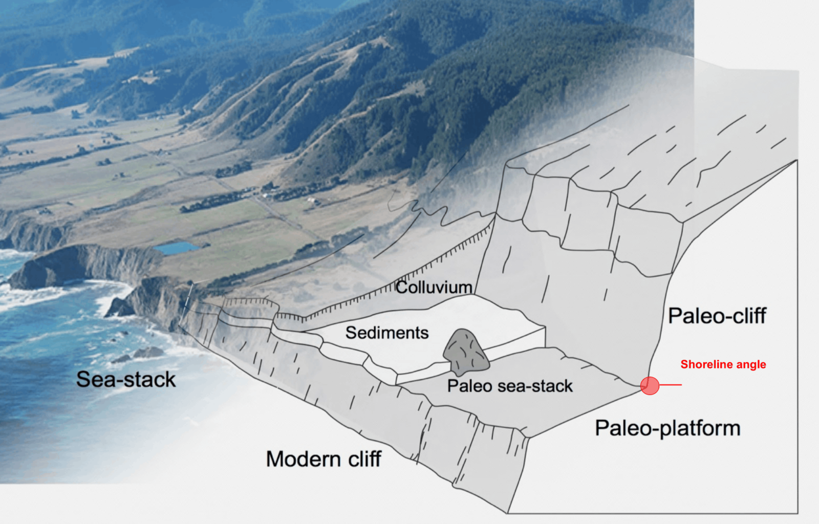
Anatomy of a marine terrace. Jara-Muñoz et al 2016 (PhD thesis). Modified from Bowles and Cowgil, 2013 / Photography by Reimer 2014 Flickr©
To measure a marine terrace, researchers usually analyse topographic profiles and identify a key point called the shoreline angle – where the flat terrace platform meets the ancient cliff. This point represents the highest reach of the sea level during the past sea-level position. Traditionally, this step has been done manually, which introduces an unknown amount of uncertainty, for instance experiments presented in the latest release of TerraceM-3 shows that:
a) Different people may choose slightly different marine terrace elements
b) Experience strongly influences the result of marine terrace mapping
c) Even with the same data, measurements can vary significantly between users
d) Beginners improve with practice and move closer to expert results
In short, the classical mapping method of marine terraces works, but the results strongly depend on the experience of the person doing it.
The key concept: teach the computer to think like an expert
The main advance of the new TerraceM-3 is simple but important: instead of training a user to become an expert, the approach teaches a computer to reproduce expert decisions in a consistent way. The updated open-access software TerraceM-3 uses machine learning to learn how experienced researchers identify shoreline angles. It does not create new rules. Instead, it learns from real examples and mimics expert interpretation.
TerraceM-3 produces results comparable to expert mapping, reduces differences between users, can be applied across different coastal regions. Furthermore, TerraceM-3 is provided with a pre-trained neural network reducing associated carbon costs and working efficiently on standard computers. This advance represents a shift from subjective interpretation to reproducible measurements that can be compared across different areas, reducing the bias introduced by different users.
Beyond automation: improving the workflow
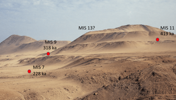
Example of marine terraces discovered using LIDAR data at Pelluhue, Central Chile (PC: Julius Jara-Muñoz).
The improvement is not only about automation, the software also introduces a structured workflow that guides users step by step reducing the chance of mistakes. TerraceM-3 is also designed to use widely available satellite-derived elevation data of the ICESat-2 mission of NASA, democratizing the mapping of marine terraces by allowing researchers to work in regions where high-quality topography is non-existent or difficult to access. By standardizing how measurements are made, the method reduces both random errors (from individual interpretation) and systematic errors (from inconsistent mapping approaches).
Why this matters
As mentioned at the beginning, marine terraces are key to understanding how the Earth’s surface moves and how the climate change has modelled the coastal landscapes over thousands of years. TerraceM-3 provides new tools to accurately measure these landforms, reducing the uncertainty in results and interpretations, and refines our understanding of climate changes, coastal erosion and accumulation, the response of the earth’s crust to glacio-isostatic adjustment, and the role of earthquakes in building the coastal landscape, among others. This tool is intended to allow scientists to read the history recorded along fossil coastlines more precisely and accurately and in a repeatable manner. Finally, it is important to highlight that this tool does not replace human expertise. It captures it, standardizes it, and makes it reproducible and accessible to the scientific community. TerraceM can be downloaded at