by Stratis (Efstratios) Karantanellis, Professor, Geohazards and Remote Sensing Lab, Department of Geological Sciences at California State University, Fullerton. Email: ekarantanellis@fullerton.edu, website: https://sites.google.com/view/stratiskarantanellis
Santorini is one of those places that doesn’t quite feel real at first glance. White houses stacked on cliffs, blue domes, the Aegean stretching out in every direction. But once you step closer to the edge, especially along the caldera, you start to notice something else: the landscape is constantly moving. Earlier this year, my team and I headed to Santorini to look at landslide hazards. I spent a lot of time around Red Beach, where steep red volcanic cliffs drop straight into the sea. It’s a stunning place, but also one where rockfalls are frequent enough to close access from time to time. What we wanted to understand wasn’t just where failures might occur, but also how these slopes evolve and whether we can track that change in a meaningful, measurable way.
Most mornings started early, before the wind picked up and before the first wave of tourists arrived. Red Beach at sunrise feels like a different place, quiet, almost still, even though you know the slopes above you are anything but stable. Geology explains much of that instability. The cliffs are made up of layered volcanic deposits, ash, pumice, lava flows, sitting on weaker materials. They’re fractured, weathered, and in many places, already close to failure. But identifying exactly where and how things might move isn’t straightforward, especially when much of the terrain is too steep to access safely. This is where our approach is built on earlier work we’ve done using UAVs for object-based landslide analysis. Instead of just mapping the landscape visually, we treat it as a collection of “objects”, distinct geomorphic units that can be classified based on their geometry, roughness, slope, and texture. Using drone imagery and LiDAR, we can segment the terrain into meaningful pieces: intact rock masses, loose debris, scarps, and accumulation zones.
In Santorini, that conceptual approach became even more powerful when combined with high-resolution 3D data. Flying along the caldera cliffs wasn’t always easy, the winds had their own plans, but once we captured the data, we could reconstruct the slopes in remarkable detail. Features that would be easy to miss in the field, minor fractures, small detachments, and surface changes, stood out clearly in the point clouds. But the real shift came when we stopped thinking of these objects as static. We repeated our surveys and started comparing them. Instead of a single 3D model, we now have multiple snapshots of the same slope taken at different times. That’s where things moved from 3D into something closer to 4D.
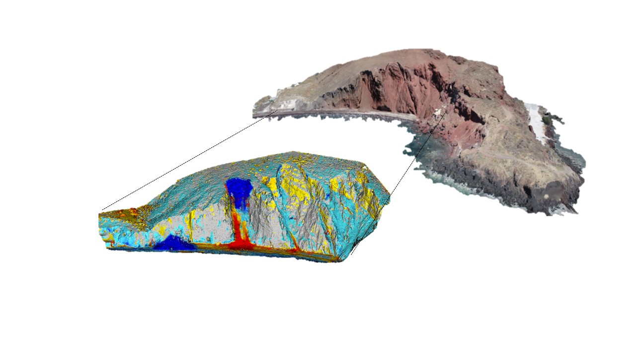
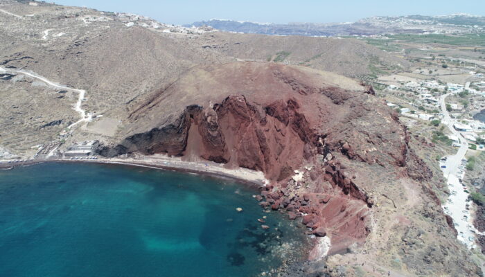
Figure 2. 3D surface change model of the Red Beach, Santorini, Greece. PC: Stratis
Karantanellis
I remember one specific spot at Red Beach. After a light rain, we revisited an area we had already scanned. Standing there, nothing looked different. But when we processed the data and ran a comparison, small changes appeared, tiny volumes of material had shifted, and the boundaries of certain “objects” had subtly changed. That’s where the connection to object-based analysis really clicked. It’s one thing to map a landslide scarp or a deposit patch; it’s another to track how those features evolve. Objects can grow, shrink, merge, or disappear entirely. By combining object-based segmentation with multitemporal 3D data, we’re no longer just identifying hazards; we’re observing how they develop. Of course, the fieldwork itself had its usual mix of challenges and lighter moments. One drone decided to land in a patch of bushes (a good outcome, all things considered). Tourists occasionally gathered, assuming we were filming something cinematic rather than scanning unstable slopes. And residents shared stories of past rockfalls, blocked roads, and closed paths, which grounded our data in real experience.
Back in the lab, we processed everything into terrain models and ran change detection analyses. The patterns were subtle but consistent. Certain areas kept showing low-level activity. Not major failures, but enough movement to suggest that these slopes are continuously adjusting. That’s really the key takeaway. Landslides aren’t always sudden, catastrophic events. Often, they’re the result of small, incremental changes building up over time, and those are exactly the kinds of changes that traditional methods tend to miss. This is where continuous monitoring becomes essential. With extreme weather events becoming more frequent and intense, the conditions that trigger slope instability, heavy rainfall, rapid saturation, and even seismic responses are also becoming less predictable. Having the ability to repeatedly capture high-resolution 3D data means we’re no longer limited to before-and-after comparisons. Instead, we can begin to track how instability develops, step by step, and identify early signals that might precede larger failures. What makes this particularly powerful is the combination of that temporal dimension with object-based analysis. It’s not just about detecting that something moved; it’s about understanding what moved, how, and where within the slope system. That level of detail opens the door to more targeted hazard assessments and, potentially, more effective mitigation strategies. What stayed with me from Santorini wasn’t just the landscape, but the shift in how we study it. By combining UAV-based object analysis with repeated 3D surveys, geomorphology becomes dynamic and measurable rather than purely descriptive. Standing above Red Beach, it’s clear the cliffs won’t stay the same. What’s new is that we can now follow those changes as they happen, one dataset at a time, and that opens the door to understanding, and maybe even anticipating, the next failure.
Please contact Emma Lodes and Anna van den Broek (GM blog editor, elodes@asu.edu, a.j.vandenbroek@uu.nl), if you’d like to contribute on this blog!